Thursday 26 May 2011

Hard Knott and Esk Pike

Monday 25th April 2011

The weather for this walk was a little cooler than the previous day's, but not by much. It was still a warm day and afforded me with clear views all around Upper Eskdale. I set off from the youth hostel and walked up the valley, trying to avoid the road by crossing Doctor Bridge and following the footpaths to the south of the river, but I still hit the road at Jubilee Bridge at the start of the steep pull over Hardknott Pass. This is a difficult climb for cars but on this day many cyclists were also slowly making their way up the winding road. Rather them than me! I was slowly walking up the hill, past the Roman Fort of Hardknott (there isn’t much to see so I didn’t linger) and on to the top of the pass. With views down the other side of the pass into Dunnerdale, I climbed up the fell that lends its name to the pass: Hard Knott.
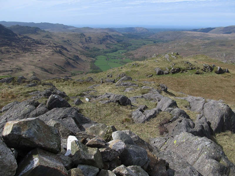
After all the agony of the climb to the top of the pass I was now able to enjoy myself as I explored the various tops around Hard Knott, starting with Border End which overlooks the pass. With views of the Eskdale Needle below and the great fells that surround Eskdale on the horizon, I crossed the complex terrain to the summit of Hard Knott and with this Wainwright bagged I now had only three left to complete all the Wainwrights. I continued my exploration of Hard Knott, eventually stopping at a cairn on the last outcrop on the northern slopes and there I kicked off my boots from my aching feet as I relaxed in the shelter of the outcrop and had my lunch while gazing out across the gorgeous scenery of Eskdale. Now that my goal for the day had been accomplished I was unsure what I was going to do next. Originally I'd planned on climbing the unending grassy slopes of Crinkle Crags, but I was now too tired and weary to try it.

As I neared Lingcove Beck I decided I would follow the stream all the way up the valley, but little knowing that it was going to be a very long and tiring way. I had never been along the path all the way to Ore Gap before so thought it would be a good idea; I now know how far it is. After frequent stops to catch my breath I eventually reached the top of the pass at Ore Gap, where I turned left and climbed the gloriously stony terrain to the summit of Esk Pike. This is a fabulous fell, tragically overlooked by its bigger neighbours but deserves far greater recognition due to its complex rocky terrain and stunning views. After a rest I headed straight down the awesome, pathless south ridge of Esk Pike. This was a great descent as I picked my own route down the long, crag-filled ridge. Despite coming to a dead-end at a cliff top, and having to climb back up, I thoroughly enjoyed this ridge. I climbed this way some years ago and enjoyed it then and now was no different as I relished in the freedom and ease of the descent.

Eventually I reached the River Esk near Scar Lathing where I was easily able to cross the river due to the recent lack of rain. I wanted to walk through the Esk Ravine on the steep, western side, but this is a very tricky path that even Wainwright warned against saying that it enters a gorge below Green Crag from which escape is difficult (well, that was what attracted me!). It was indeed difficult to get through the ravine, but it could have been tougher. At one point I was given a choice of routes and I took the upper path, but I can’t help thinking that the lower path would have been more exciting, though I think I was wary of the possibility of the lower path having subsided into the ravine. A return trip to investigate is called for I think. I continued beside the river and walked all the way to the youth hostel along the bottom of Eskdale. This was a fabulous walk in a great area of the Lake District. I just love Upper Eskdale as one can walk through it all day, on a Bank Holiday Monday, and hardly see anyone, and this walk showed off the valley at its best. There is nowhere better in the whole of the Lake District.

Thursday 19 May 2011

Scafell Pike by Piers Gill

Sunday 24th April 2011 

The evening before this walk someone in the youth hostel I was staying in said the weather forecast for the next day was the best that he'd ever seen for the Lake District. It was perfect. There were clear blue skies all day with an occasional cold breeze to cool the heat of the day. To accompany these amazing conditions I did a very challenging and tiring walk across the highest hills in England. To take the easier routes would have been too simple so I took the hardest routes I could find just to more successfully wear me out. And it worked! 

I set off from Seatoller and walked along the Seathwaite road as far as the Seathwaite Bridge and from there I followed the river past Seathwaite around the foot of Base Brown up to Taylorgill Force. I absolutely love this wonderful path; in fact it may be my favourite path in the Lake District. It is a bit of a scramble, perched on the side of a steep cliff face, and affords close up views of Taylorgill Force. It is the perfect path. I first walked this path on my first ever visit to the Lake District, and I have loved it ever since, but it must be five years since I last walked up it. That is just too long. Soon however I was past the waterfall and climbing beside the stream up to the top of Sty Head Pass. 

Passing over the top of the pass, I descended on the little used valley-route path towards Wasdale. This is a lovely little path that cleverly snakes up the steep hillside from the stream below, but all too soon I left the path and crossed the steep hillside to Piers Gill, joining the path near the confluence of Greta Gill with Piers Gill. The path climbs steeply up the rock-strewn terrain and afford me with vertiginous views into the deep ravine of Piers Gill to my right. I had never been up the Piers Gill path before and I found it very challenging, but also with some stunning views. This was a tough, tiring climb that required a bit of a scramble, but eventually I reached the Corridor Route and finally I crossed Piers Gill. 

I didn't stay on the Corridor Route for long but branched off to cross Lingmell Col and climbed up to the top of Lingmell, where I had my lunch. I had been up Lingmell only once before, which is a great tragedy considering the number of times I’ve been up the neighbouring Scafell Pike. The views from the top of Lingmell were quite stunning with an all-round panorama that was only supplemented by the views of Scafell Pike that dominated the scene to the south across the col. One could argue that the views from the top of Lingmell are better than those from Scafell Pike and with a wider summit area there was plenty of scope for exploration. I wish I’d spent more time on Lingmell, but I still had a long way to go so after lunch I crossed Lingmell Col and joined the crowds climbing up Scafell Pike. Having come so far it would have been a shame to leave out the highest mountain in England. 

I went up Scafell Pike Easter Sunday last year but the conditions at the summit then were completely different to Easter Sunday this year. Last year there was still quite a lot of snow at the summit, now there was no snow at all and instead I found warm, bright sunshine. It’s amazing how conditions at the top of a mountain can vary Easter to Easter. I’ve been walking at Eastertime for more than ten years and I have encountered snow and cold, hard rain as well as warm, clear skies. It’s an interesting time to go walking and there is no better time. The summit of Scafell Pike was as ridiculously busy as usual so I didn't stay long and immediately headed towards Mickledore, the gateway to Sca Fell, the second highest mountain in England. 

There are only two routes from Scafell Pike to Sca Fell, and the direct one up Broad Stand is not one of them, so both routes required me to circumvent the huge crag that was blocking my way. The easier (and recommended) way is via Foxes Tarn (still not particularly easy), and the harder way is up Lord’s Rake, so that's the route I took. At the end of the narrow connecting ridge of Mickledore I dropped steeply down treacherous loose stones to a path that crosses the foot of the enormous Scafell Crag to Lord's Rake. I have been up Lord's Rake twice but this time it seemed much harder. The rocks in the area are disintegrating and nowhere more so than in Lord's Rake itself. I found it a really difficult to climb up the steep loose stones and dirt that comprised the rake, and I was greatly relieved when I eventually reached the top. I suspect that Lord’s Rake will eventually become impassable to anything other than superhuman effort, and that prospect fills me with great sadness.

I had originally intended on taking the West Wall Traverse from Lord's Rake, but I didn't like the crumbly state of it so I stayed on the straight route over the top of Lord’s Rake, across a couple more steep, though easier rakes, and eventually emerged on the side of Scafell. Now I had to climb steep, rock strewn terrain all the way up to the summit of Sca Fell, which was a long way away, so by the time I reached the top I was really tired and just collapsed in a heap beside the summit cairn while taking in the stunning surroundings. After a rest, and a bit of Kendal Mint Cake, I started off down the long southern slopes of Sca Fell all the way to Eskdale. 

I came up this path on my first visit to the Lake District and I found it to be a far too lengthy climb. On a later visit I descended by this route and found it to be a delightfully relaxing descent, known as the Terrace Route, but on this occasion I was possibly too tired to be able to enjoy the faint path. Eventually I came down into Eskdale where a short walk along the valley road took me to the youth hostel. This was a really tiring walk, but in stunning weather, over some truly amazing and challenging terrain, and through some absolutely stunning surroundings. This was the Lake District at its best.

Thursday 12 May 2011

Blencathra by Sharp Edge

Saturday 23rd April 2011

I returned to the Lake District last Easter and for the first time in five years I had a whole week in front of me to enjoy in this most delightful of places. On this holiday I got to revisit places that I had not been to in a long time and even got to places in the Lake District that I’d never been to before. My first stop was Blencathra, one of the greatest fells in the Lake District, and this walk that I did must be one of the greatest in the whole of the Lake District. I got off the bus at Scales and climbed around the steep side of Scales Fell to the top of Mousthwaite Comb and up to Scales Tarn where my target for the day was basking in awesome splendour: Sharp Edge. 

I have only once been up Sharp Edge before and that was in December 2006, in damp, cold weather. Ever since then I have wanted to go across this knife-edged ridge in good weather and now finally I had my chance. The weather still wasn't brilliant, it was overcast with a cold breeze, but it was dry and Sharp Edge was clear of clouds. After having my lunch near Scales Tarn I set off up to the start of the fabulous rocky traverse. This is an excellent climb, especially if the side paths are spurned in favour of sticking to the very top of the jagged edge. When things started to get serious I took a challenging line in my scramble up the rock face, and enjoyed every terrifying moment.
Eventually I reached the summit of Atkinson Pike where I traversed the saddle to the summit of Blencathra. During my ascent I was fascinated by a path that I had seen: at Scales Tarn a clear path moves up the hillside opposite Sharp Edge straight towards the summit. This path is not marked on OS maps but I later discovered that it is marked on Harvey maps and in the second edition of Wainwright’s Pictorial Guides. I didn't linger at the crowded summit but immediately took the excellent path that heads down Hall’s Fell Ridge. This is a fabulous way to come down a mountain; descending on rocks almost all the way as I tried to stick to the most interesting lines so I could enjoy every moment of the prolonged descent. The rocks were really dry which ensured a good grip and enabled me to confidently walk down the steep ridge. When I finally reached the bottom I crossed farmland to reach the village of Threlkeld. 

From Threlkeld I joined the enjoyable Keswick Railway Path, which is a wonderful path that follows the course of an old railway that used to run through Keswick. I have used the path many times in the past but like many other places in the Lake District I haven't been on it in recent years. Despite the rain that fell while I was on this path I had an enjoyable stroll into Keswick and relished the eight bridges that span the River Greta between Threlkeld and Keswick. This was a fabulous end to a great, if short walk up a great mountain. I was so thankful I'd been able to go up Blencathra in dry weather as the rocks on the two ridges would have been treacherous in the wet. Fortunately my luck held as in the dry Sharp Edge is a fabulous way up a mountain, and Hall’s Fell Ridge is a fantastic way to go down a mountain.

Thursday 5 May 2011

More early adventures in the Brecon Beacons

I am continuing my adventures in 2000 when I did some of my earliest hill walking in the Brecon Beacons National Park.

The Black Mountains continued

Wednesday 6th September 2000

I remember before this walk telling the warden at the hostel that I was going for a walk in the area (i.e. the Black Mountains), and because of the wet start to the day she described me as a dedicated walker. I replied that I was more like a crazy walker, but as it turned out the weather for this walk was much better than on the previous day. After the wet start it was clear, warm and sunny, though still very windy on the hills. I did the walk that I had planned to do the day before, but this time starting from Capel y Ffin rather than the Gospel Pass. Once again I climbed that path out of the Vale of Ewyas onto the Offa’s Dyke Path that has enchanted me so many times. After coming down this path the day before I now knew the correct route to take and so for the first time was able to climb up to the pile of stones on the Offa’s Dyke Path that marks the top of the path. However, unlike on previous occasions I now proceeded over the other side of the broad ridge and down into the valley opposite.

After descending into the Olchon Valley I crossed the farmland and climbed the narrow ridge up to the top of Black Hill. This is a fabulous ridge as I was reminded a couple of years ago when I revisited it. I passed the Offa’s Dyke Path again and climbed up to Hay Bluff before crossing the Gospel Pass to Twmpa. From the wide sweeping views of the Wye Valley at the summit of Twmpa I descended into the side valley of Nant Bwch that took me all the way back into the Vale of Ewyas and Capel y Ffin. I have long memories of this fabulous walk, describing it as ‘very enjoyable’ in my diary. It was a great walk in surprisingly good weather.

The Waterfalls Walk

Thursday 7th September 2000
The following day I drove across the Brecon Beacon moors (long favoured by Top Gear car reviews) and parked in the village of Pontneddfechan where I set off walking alongside the Nedd Fechan and visited the spectacular Waterfall of Our Lady (Sgwd Gwladus). This area of the Brecon Beacons National Park is packed with waterfalls with this great waterfall being merely a foretaste of the delights to come. Continuing along the Nedd Fechan I passed the Horseshoe Falls (Scŵd Ddwli) and eventually reached the Pont Melin-fach picnic site. Rather than continue along the river I immediately climbed out of the valley at this point and passed over the top of a low hill to descend into another valley, this time that of the Afon Mellte.

This valley also has waterfalls in abundance, but some are difficult to get to. The first one has no such problem: Sgŵd Clun-gwyn is another stunning waterfall that one can easily stand right in front of and I remember for some reason standing right in the line of spray that came from the waterfall. Due to the rather wet weather conditions that had been plaguing me most of the day I was wearing waterproofs, but I must have still got rather wet. After crossing the river I followed a path that frustratingly climbed the hillside away from the river and robbed me of views from the other waterfalls further downstream. I now know how difficult it is to be able to see these waterfalls, but I didn’t know that at the time. However, there was still one waterfall left and this is the greatest of them all. At the end of the path was Sgwd yr Elra, a waterfall that one can walk behind (I have heard that at times this path has been closed due to safety concerns – I don’t know what the current state of the path is). From Sgwd yr Elra a delightful woodland and moorland walk took me all the way back to Pontneddfechan and my car. Heavy rain during this final part of the walk failed to dampen my enthusiasm for this fabulous walk and in fact I quite enjoyed walking through the rain! When it rains a waterfall walk is the best walk that you can do.