Thursday 26 July 2018

Skiddaw or bust

Tuesday 8th May 2018

With the good weather from the previous weekend lingering at the start of the day, even though rain was forecast, I left Keswick and headed through the fields north of the town to reach the village of Applethwaite where I took to the quiet, narrow roads while to my left a grand view could be seen towards Keswick and Derwent Water with the surrounding fells beyond. This view is described on a plaque beside the Underskiddaw Church Room just outside Applethwaite that declares: “I will lift up mine eyes unto the hills, from whence cometh my help.” These are fabulous sentiments that often come to my mind when I am in the Lake District, and I have fond memories of this particular spot and the text it contains ever since I first saw it on one of my earliest visits to the Lake District in 2003. When I got to Millbeck I turned off the road and headed steeply up the hillside initially up a close-cropped grassy field. The steepness of the terrain prompted frequent halts that were amply rewarded by the tremendous view behind me across the fields to Derwent Water and the surrounding fells. Fortunately the sun was still shining at this point and I was thoroughly able to enjoy the view, although a lot of the fells seemed to have already acquired caps of clouds and provided a foretaste of what was to come.

After passing over a stile, heather took over the landscape while the footpath began to zigzag lazily up the steep hill. This was greatly received by me as I slowly dragged myself up the fell while behind me the views continued to expand and the clouds slowly increased in size over the high fells, though they still allowed gaps for the sunshine to peek through in between. The views continued to be fabulous until I reached the low crags of White Stones by which time the clouds now covered much of the fells, especially Skiddaw ahead of me where dark clouds had been drawn to the summit, so I knew it would not be long before they would envelop me and rain would follow.  I reached the clouds before the top of Carl Side, so I donned my waterproof top and not long after that my gloves and a woolly hat followed as the cold weather that had afflicted my holiday during the first week returned. The hot weather of the Bank Holiday weekend was now a distant memory, but surely cold, windy and wet sounds about right for the Lake District? Hot and sunny just never seems right in the Lake District, even though it’s always gratefully received.

Passing Carlside Tarn, possibly the smallest named tarn in the Lake District, I climbed the long, tedious scree slope that leads very steeply, and becoming even steeper as I climbed, all the way up to the summit ridge of Skiddaw not far from the middle top. It was now really cold, which always seems to be the case for me at the top of Skiddaw. I must climb Skiddaw in warm weather one time just to see what it feels like, although that would probably not feel right! Heading north along the ridge I stopped briefly at the summit before continuing north until I reached the north top where I sheltered behind a cairn. The clouds were broken on this side of the fell and the sun was still shining across the plains of North Cumbria, so while I sat having my lunch I gazed out over the extensive views north and east over the Back o’ Skidda’. Eventually I tore myself away from the views and headed back into the thick cloud and over the top of Skiddaw following the ridge down to the saddle with Little Man and up to the summit where Wainwright declared was the best view from the summit of any fell in the Lake District, but not when I was on Skiddaw Little Man at that moment.

Over the previous couple of days my right knee had begun hurting, especially during descents, so at the end of the previous day I had bought a knee support in Keswick, but it was still tricky for me when descending from Skiddaw and Little Man was even worse as it is steeper. My knee complained vociferously all the way down until the terrain eased and I made my way past the main tourist path following a fence over Jenkin Hill as the long-anticipated rain finally began to fall furthering the continuing deterioration in the weather. After briefly visiting the summit of Lonscale Fell I turned north and agonisingly descended the grassy slopes to reach the narrow Burnt Horse ridge that took me down to the bridleway and finally to the Skiddaw House hostel. I had planned on continuing east to climb Blencathra at this point, but after my slow progress thus far on the walk due to my dodgy knee and the deteriorating weather I decided it would be best to head straight to the hostel, despite it being very early, so I could take the opportunity to rest my knee.

This walk somehow felt more Lakeland than on my previous couple of days with the weather turning once again cold and windy. I still had stunning views and sunshine at the start of the climb and towards the north, but on the tops of the fells the clouds had descended obliterating all views anywhere. I should have been resting my knee for several days, but I wasn’t prepared to do that while in the Lake District, so instead I walked up one of the highest fells in the whole National Park. However, I did stop at that and I didn’t climb Blencathra, so in my goal of climbing all the High Fells in the Lake District I had reached thirty-one fells, but I had now failed to reach three of the fells. Nevertheless I was still determined to keep on with my goal of climbing as many of the High Fells as possible and after a good rest at Skiddaw House I was able to continue my attempt.

Thursday 19 July 2018

Grasmoor and Grisedale Pike

Monday 7th May 2018

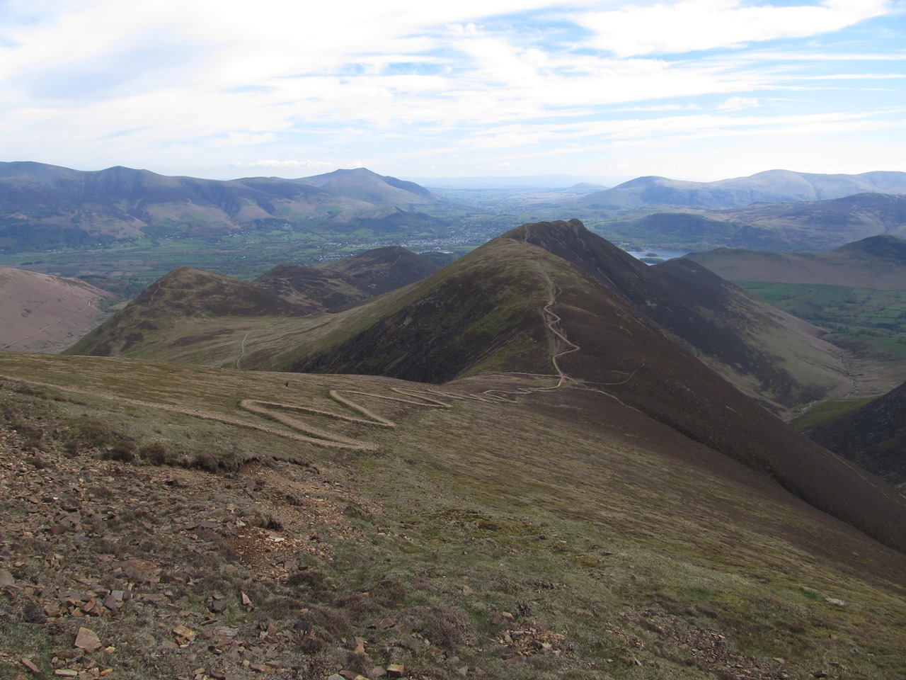
Enjoying good weather once again in the Lake District, I set off under hot blue skies from the Buttermere Youth Hostel down to the village and through the lovely, wooded gorge of Mill Beck and onto the path that goes through the pass above Sail Beck. This was a long walk on a narrow path perched above the slender stream below the steep grassy slopes of Whiteless Pike and Wandope. Grass dominated the landscape with the occasional sheep revealing the reason for this desolation. Before reaching the top of the pass I came off the path to climb steep heather covered slopes up to Sail Pass and the abomination that is the footpath either side of the pass, where completely unnecessary, raised zigzags have been created on the gently sloping hillside that once had a straight path. I remember climbing this path in 2004 and I don’t recall there being much erosion at this point and it certainly didn’t warrant such heavy handed footpath manufacture now. Beyond the zigzags the original path continues over the top of Sail though it fails to reach the small cairn a short distance away that marks the summit. having moved off the path to bag the summit I had now reached my twenty-fourth High Fell of this holiday.

After the summit the ridge narrows spectacularly as it makes a short, steep descent that was agony for me. Over the past couple of days my knees had begun to hurt during the descents until by the end of the previous day's walk while descending into Buttermere my right knee was really painful. Up to this point on this walk my knees had been quiet, but on this short, rocky descent my right knee startled me by its angry complaining. This probably detracted from my enjoyment of this fantastic, craggy ridge that spans the gap between Sail and Crag Hill as I dropped down to the col before climbing delicious rock-covered slopes where hands are needed as much as feet all the way up to the top of the hill. Ordnance Survey call this fell Crag Hill, but Wainwright called it Eel Crag even though he acknowledged that the name was inaccurate and defended himself simply by claiming long usage of the name and conservatism, but for me it is my twenty-fifth High Fell. While extending my walking pole I took a look at the fantastic views that can be seen from the top of Crag Hill, especially the view down Coledale towards the northern fells of Skiddaw and Blencathra that was increasingly hazy into the distance.

With my pole extended I was able to ease the pain in my knee for the descent around the top of Addacomb Hole and up to Wandope where there are also good views especially south and east with the Scafell Pikes on the horizon taking pride of place. It is astonishing that such a minor top among giants should afford such great views that surpass even those of its neighbours. Crossing the pass I climbed the broad slopes of Grasmoor to reach a cairn at the head of Rannerdale where I paused to once again take in the view on this glorious day. Although the terrain had levelled, the actual summit of Grasmoor was still quite a distance away across the long plateau past several cairns, but it was such a lovely day it was just a sheer pleasure to walk across the top of Grasmoor until finally I reached the large cairn that marks the summit of Grasmoor, the highest point in the north-western fells and my twenty-seventh High Fell. Stunning views were revealed from the summit looking west across the Solway Firth towards Scotland, but I didn’t linger long and turning around I crossed to the northern edge of the plateau to walk around the top of the stunning Dove Crags before starting the descent towards Coledale Hause.

The great views continued during the descent with Grisedale Pike dominating the view and once I reached the pass I stopped to have my lunch while gazing down the length of Coledale sitting under the shadow of Eel Crag. After eating I slowly climbed the steep, loose stones of Sand Hill, a top that seems misnamed as it’s not sandy at all and is rather a dull mound. It isn’t high enough to be on my list of High Fells (and it’s also not listed by Wainwright), but all that effort was not for nothing as hidden just beyond the top is the much more satisfying High Fell of Hopegill Head. From this point fantastic views suddenly opened up before me in many directions such as north along the ridge over Ladyside Pike while west a stunning narrow ridge extends all the way to Whiteside, but the best views were round the top of Hobcarton Crag and round to the top of Grisedale Pike, and all this from a tiny eagle’s nest of a summit. Following the cliff-edge above Hobcarton Crag I slowly and painfully hobbled down to the depression before climbing all the way up to Grisedale Pike, my sixth High Fell of the day and matching my record from the first day of my holiday in the Lake District.

The most direct route down is along the east ridge over Sleep How, but for many years I have been interested in taking the north ridge over Hobcarton End. I had intended on climbing that way in 2007 only to find myself on the shorter and steeper north-east ridge. Ever since I have wanted to take the north ridge and preferably in descent, and now, finally, I have satisfied that desire despite the pain in my knee on the steep descent. Eventually I entered the Whinlatter Forest where the path became rather muddy and chaotic weaving amongst the trees, and then split with one path leading to a fallen tree which prompted me to take the other path. However, this path began descending very steeply through the trees zigzagging down on a narrow track that looked rather like a mountain bike trail despite not being official. Nevertheless, I had tremendous fun on this trail as I ignored the pain in my knees and zoomed down the path weaving amongst the trees until eventually I came down to the wide forestry track at the bottom that brought me to the Whinlatter Pass road. Crossing the road I entered the complex of buildings and car parks for the Whinlatter Forest Park visitor centre where, after a little difficulty, I found the bridleway that I wanted and set off along the wide track.

After a while I saw a sign for Comb Beck Trail down a narrow footpath that seemed better than the track I was on, so I took that path down to a delightful stream past several ponds until the trail started to ascend once more at a delightful spot beside an old dam. There I discovered the bridlepath that I had abandoned earlier that follows Comb Beck through lovely woodland scenery and shows you don’t have go up high fells to have a good walk in the Lake District. Eventually I came into the village of Thornthwaite where I had intended on catching a bus to Keswick, however it was still early and the next bus was in forty-five minutes, so I decided to start walking following a path along the side of a wood into Braithwaite and ultimately walked all the way into Keswick. The weather was fantastic on this walk being really warm with gorgeous views that enabled me to climb six High Fells and still walk along a woodland trail at the end. Fortunately after the initial complaint my knee didn’t hurt too much for the rest of the walk, though I would have to do something about it for the rest of the holiday.

Saturday 14 July 2018

High Stile and Dale Head

Sunday 6th May 2018

With the prospect of hot weather the whole day I set off from the Ennerdale Youth Hostel soon coming off the forestry track to climb steeply up the hillside all the way to the top of Red Pike. After my disappointments of the day before I wanted to change my original plan for this walk, which was simply to walk along the High Stile ridge from Scarth Gap Pass and would not take me very long. In order to keep my options open and take advantage of the good weather I climbed straight up to Red Pike and walked along the High Stile ridge in the opposite direction. I have taken this path twice before, in both directions (in 2013 and in 2016), but on neither occasion did I complete the whole route despite a clear path almost all the way up to the top. It is a tedious and unexciting climb and under the cloudless skies it was tiring, thirsty work and towards the top the direction becomes rather vague. A line of cairns is supposed to lead the way, but these are sometimes too small to distinguish from the natural outcrops, however I did eventually succeed in finding my way all the way up to the top of Red Pike where I beheld the stupendous view. Across the hilltops north, the Newlands valley pointed towards Blencathra while to my left I could see along the length of Crummock Water to the flatlands of West Cumbria where sea fog covered the coastal plains.

The weather was fabulous and thanks to my early start and quick ascent I had the top of this popular fell all to myself. Slowly I set off along the ridge climbing to the top of High Stile, which was my twenty-third High Fell of this holiday when I had set myself the target of reached the top of as many of the High Fells as possible. This was my only High Fell on this walk so to fill the rest of the day I just followed my nose going over many great but smaller fells. The ridge between High Stile and High Crag needed no encouragement as it is a fabulous ridge that I have walked over many times, sometimes even on the same day (in 2011), and on this occasion it was extra special as I had it on my own and in great weather. After High Crag there is a steep scree slope down Gamlin End that I remember first climbing in hot weather in 2002. Since then a good path has been constructed to remove some of the horrible scree runs, but it could not hide the steepness of the terrain or the strong winds that seemed to be blowing at that moment. By the time I reached the Scarth Gap Pass at the bottom I still had no definite idea where I would be continuing the walk, but the diminutive Hay Stacks beyond the pass could not be missed.

I tackled the scrambles up to the top with relish enjoying every step despite now being joined by many other people also climbing this deservedly popular hill that was much loved by Wainwright. After exploring the top I made my way down past Innominate Tarn to the mouth of Blackbeck Tarn where there is a stunning view through the narrow opening towards the lakes of Buttermere and Crummock Water. Continuing along the path I crossed Warnscale Beck to reach the remains of Dubs Quarry where I followed the course of an old tramway to the site of the Drum House where I stopped to have my lunch. I had considered turning left at Dubs Quarry onto the Bridleway that would take me down to Warnscale Bottom, but having turned right I was now heading towards Honister and even further away from my destination, though it seemed my route for the rest of the day was set. While eating I noticed there is a quarry road a short distance to the north and checking on my map I saw that this is the right-of-way rather than the old tramway that I and everyone else always take. I was curious to see what I had been missing, so after eating I nipped across and descended the wide track that zigzags steeply down the hillside all the way to Honister and once across the pass I started the climb up the long grassy slopes of Dale Head.

This had sounded like a good idea for prolonging the walk, but as I slogged up the steep hillside I was beginning to have my regrets, though these were instantly forgotten when I eventually reached the top of Dale Head where there is a fantastic view down the Newlands Valley that was totally awe-inspiring and kept my attention until finally I turned left and headed along Hindscarth Edge. Turning right I headed up to the large cairn that marks the summit of Hindscarth while overhead the clouds that had been slowly growing during the course of the day began to congregate with Scafell Pike managing to attract some surprisingly dark clouds. It was still a fantastic day, but a cold wind was blowing that kept the temperature from getting too high on the exposed tops. From the top of Hindscarth there is a path that cuts the corner round to the bottom of the depression on the ridge that leads to the next fell, Robinson. It is so badly eroded it is not worth taking as is usually the case with most of these modern shortcuts that have often been created by fellrunners. The old paths are always the best. From the top of Robinson I headed steeply down the western slopes on a good path that brought me into the horrible bog of Buttermere Moss.

I remember crossing this marsh in wet weather in 2002 and I have avoided it ever since. I wish I hadn’t taken this route now as it is still horribly boggy with little or no trace of a path to follow. Eventually I safely reached the far side of the bog where a good, well-graded path led me steeply down into Buttermere although my knees screamed in agony with every step. This walk was considerably longer than planned, but it still did not take me much more than eight hours. The weather was fabulous with a bit of a brisk wind but excellent sunshine that afforded me with tremendous views and rewarded me for electing to keep walking all the way around the tops that enclose Buttermere so I could enjoy the weather for as long as possible.

Friday 6 July 2018

Pillar and Steeple

Saturday 5th May 2018

With good weather finally coming to the Lake District I set off from the Ennerdale Youth Hostel across the valley and along the forest track on the other side heading back up the valley. Ennerdale was looking gorgeous in the morning sunshine with a beauty that would have been impossible to imagine twenty years ago. Recently attempts have been made to re-wild the former timber plantation of Ennerdale and all the effort is beginning to reap benefit with the River Liza returning to more natural sweeps with wide banks now replacing the former restricted flow. Just comparing the latest Ordnance Survey maps of the valley with the first map I bought of the area dated twenty years ago shows the dramatic change in the flow of the river. It is going to take a long time for the conifer trees that had been planted for timber production to be replaced by native trees but it was pleasing to see the progress that has already been made. I had a pleasant walk along the track until on reaching the crossing of Low Beck I took a wet path that climbs steeply beside the stream past some lovely waterfalls in a deep ravine until I reached a higher forestry track. A short walk along this brought me to a path that took me up to the edge of the wood where for the first time on this walk I had views down the valley towards Ennerdale Water and looking into the sun up the long slopes of Pillar.

After crossing High Beck I slowly climbed the steep ridge past White Pike and up to Pillar, which had originally been planned as my route of descent from Pillar until things changed. A faint path took me up the grassy slopes until I reached a boulder field that left me struggling to climb the steep stony slopes with hardly any path to aid my progress. As I climbed, it became quite cold forcing me put on a woolly hat and gloves even though I was still wearing just a single top. After passing White Pike, the Pillar Rock itself briefly came into view before I plunged into the hill fog that still clung to the hills on the southern side of the valley. Everywhere north of Ennerdale was free of clouds and basking in bright sunshine which was unfortunate for me as I was walking south of the valley. On reaching the broad summit plateau of Pillar and the trig point that marks the top I finally put my cagoule on and enjoyed fleeting glimpses through the clouds most notably towards Ennerdale Water. I had reached the top of Pillar by eleven o’clock which made me start to think my schedule was not going take me all day, but even though I have wanted to do the High Level Traverse on Pillar for a long time, I decided I did not want to do it through mist.

Therefore, instead I headed down to the suitably named Wind Gap where the cold wind that had been blowing at me all week was blowing through the pass despite the warm, sunny weather elsewhere. Climbing up from the Wind Gap I walked up past Black Crag and around the top of Black Comb along the path that heads towards Red Pike. Due to an absence of the cold wind at this point, I had a pleasant walk along the path up Red Pike until I realised the path wasn’t going to the summit and in fact, I had already walked past it. Turning up to the top of the ridge I headed back along the top until I reached the cairn that is precariously sited on the edge of the cliff above Mosedale and marks the summit of Red Pike. With a bit of an opening in the clouds at this point and hardly any wind, I decided to have my lunch despite it still being quite early. Mindful of the fact that this walk was not going to take me very long, when I set off again I walked very slowly down to the col and took a pathless route that bypasses Little Scoat Fell to reach the top of the ridge. Following the ridge over the top of Great Scoat Fell I passed down the broad grassy slopes of Scoat Fell and up the steep slopes of Haycock to reach my twentieth High Fell on this holiday.

I was still surrounded by clouds while at the summit of Haycock, but as I ventured towards the edge of the crags overlooking Ennerdale some breaks in the clouds emerged and as I slowly made my way back down towards Scoat Fell the views continued to improve. The clouds seemed to be breaking with every step as stunning views opened up before me over the fells north of Ennerdale that had clearly been basking in sunshine for most of the day, but it was Steeple that most attracted my eye. This is a prominent pinnacle that sits just to the north of Scoat Fell on a long ridge that slowly descends into Ennerdale. The clouds had now lifted sufficiently so that I was getting stunning views of Steeple as I walked past on the cliff-edge path, but I was now frustrated about my plans as my planned descent was over Steeple and it was only two o’clock. I considered going back across the Wind Gap to Pillar in order to do the High Level Traverse, but first I had another High Fell to bag. The summit of Scoat Fell is strictly on top of the wall that crosses the fell and purists have built a tiny cairn on top of the wall at that point. After visiting the summit and wandering around the top for a bit I returned to the cliff-face overlooking Steeple and finally decided that I would descend as planned down the ridge.

A path led me down the stony ground and up the steep slopes until I reached the slender tip of Steeple that is a great airy place to stand with tremendous views of the crags that lie below Scoat Fell. Looking back after starting my descent down the ridge from Steeple, I was dismayed to see that the clouds that had been lingering around Pillar when I had begun my descent had now gone and there were clear views everywhere. It was really frustrating to realise that the clouds had lifted just as I was leaving the fells and just after I had spent several hours wandering around in mist. Therefore I took my descent very slowly taking every moment with deliberate care lingering over every step while taking in the amazing views north over the High Stile ridge and the North-western Fells towards Skiddaw in the distance. I absorbed the views back along the line of crags that I was descending and to the escarpment between Steeple and Pillar taking particular note of Black Crag. I was in awe of the splendour of the views before me brilliantly lit by the bright sunshine. This should have been a great day in the Lakes, but I felt cheated and frustrated by the weather. It took me an hour to descend the ridge that is only one kilometre in length as I made the most of my position descending the path as slowly as possible.

Eventually I passed into the heather moorland above Ennerdale Forest and after crossing Low Beck the path disappeared with bogs blocking my way. I ascended Steeple by this way back in 2005 and did not enjoy the experience despite the excellence of the ridge. In 2003 I descended Steeple by this route and somehow I found a way into Ennerdale Wood beside Low Beck thereby omitting this horrible moorland crossing. I would have thought the path I took out of the wood at the start of the day must be an option, so it is curious that it has never been suggested. Eventually I passed over muddy Lingmell and reached the top of a ridiculously steep descent that did nothing to ease the pain in my knees as I slowly made my way down to the forest track at the bottom. It was very hot in the valley and when you have this sort of weather in the Lake District you want to make the most of it and that I felt I was unable to do on this walk, and that is frustrating.