Thursday, 30 January 2025

Completing the Cambrian Way

Tuesday 27th August 2024

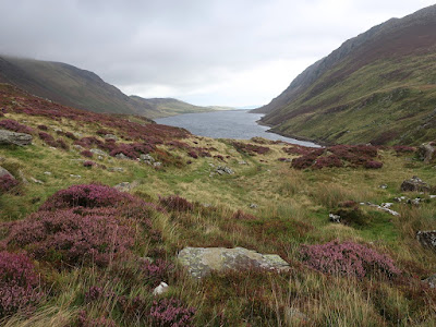
On the twenty-first and final stage of the Cambrian Way I should have been walking from Llyn Ogwen to Conwy Castle over the Carneddau Mountains, however, just as on many days in the second half of the trail, the weather was bad with strong winds and rain, so I wasn’t going to be following the mountain top route. I had considered following the Snowdonia Way starting from Bethesda, but the distance was thirty-five kilometres and would take me ten and a half hours, which was not possible when I needed to get a bus to Bethesda first and then catch a train home when I reached Conwy. My next thought was, what is the most direct route from where I was in the Nant y Benglog valley, east of Llyn Ogwen, to Conwy? So I plotted a course on my map through the mountains and along the eastern slopes above the valley of Dyffryn Conwy to finally reach the town of Conwy, which would take me six or seven hours and give me plenty of time to catch my train. After overnight rain I was surprised to wake up to dry weather and a dry tent when I put it away for the last time on this holiday. From the campsite where I had been staying I set off across the A5 road and onto a bridleway that climbs the hillside, passing the rental property of Tal Y Braich and after crossing a stream became a very boggy and indistinct path. This soon bore no resemblance to the route of the bridleway on my map and brought me to a leat, a water channel that diverts streams into a reservoir, and provided me with a good surface to walk alongside it. Eventually I reached a point overlooking Llyn Cowlyd Reservoir where strong winds pushed me along just as it started to rain.


Once I had managed to put my waterproofs on I followed the bridleway down to the side of the reservoir, which was much more sheltered from the winds, and eventually led me to the dam. The access road now provided me with a broad track to follow and led me into the valley of the Afon Ddu which was marred by a large pipeline that traverses the landscape from the reservoir. After a while I realised that I should have come off the access road and taken a path that the Ordnance Survey characterises as ‘other routes with public access’ and is marked by green dots. To get onto this I had to walk up to the pipeline and squeeze underneath it before I could reach the path that I should have been on, and which aerial views don’t show until the point where I joined it. My route brought me past a herd of cows, over the blustery hill and down a stony path into the valley of the Afon Porth-llŵyd where I found a road which would largely take me all the way into Conwy, though I still had a long way to go. Judging by the strong winds blowing through the valley I felt I was right to come this way and not brave them from the tops of the mountains. When the weather is this bad I don’t mind walking along a road as it’s the best way of getting through tedious scenery.


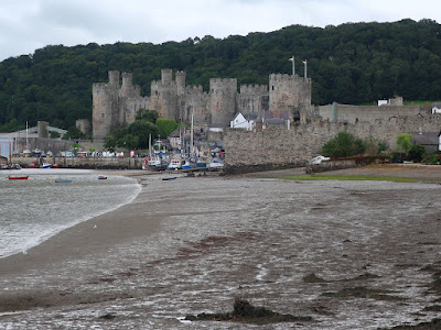
After climbing out of the valley and then down into the valley of the Afon Dulyn I came off the road for a brief spell to pass through woodland, across the stream and along an enclosed path. From the road at the far end I now stayed on narrow country lanes that followed the edge of the Eryri National Park for many tedious hours. At one point I thought I must be nearing Conwy so I checked my map and discovered that I had another hour and a half of walking to go which was soul-destroying, but I kept on through the improving weather until eventually I came into Conwy and picked up the route of the Cambrian Way. Even though I hadn’t followed the trail over the Carneddau Mountains, I was still going to complete the Cambrian Way which I had started many weeks earlier. I passed through the old walls and into the narrow streets of the medieval town, turning left into High Street and then right into Castle Street before finally reaching a roundabout beside the Guildhall with the imposing walls of the thirteenth century Conwy Castle ahead of me. One and a half months earlier I had stood before the gates of Cardiff Castle with the noise of a demonstration behind me and now I was before Conwy Castle with many tourists crowding the streets. Even though I had come off the Cambrian Way on the northern slopes of Plynlimon to take a bad weather course around the mountains I still managed to cross Wales from Cardiff to Conwy and I could be satisfied at reaching my goal.


The bad weather that had plagued me over the last nine days on the trail was just one thing that didn’t go well as I also suffered from fatigue that could have also prevented me from taking the mountain route through Eryri/Snowdonia. I don’t think I was mistaken in my belief that I could do the Cambrian Way and with the lessons learnt it is very tempting to try again. I reached Conwy by two-thirty and with my train not due for another two hours I had some time to wander around the town and begin the long recovery process from my strenuous walk along the Cambrian Way.

Thursday, 23 January 2025

The Snowdonia Slate Trail from Llanberis to Nant y Benblog

Monday 26th August 2024

Last summer I attempted to walk the Cambrian Way which starts in Cardiff and crosses the length of Wales taking a high level route over the mountains before finally reaching Conwy on the north coast. However, half way through the trail bad weather had forced me onto lower routes that took me around the mountains and this continued on the day before this walk when I should have been climbing Yr Widdfa, better known as Snowdon, the highest mountain in Wales, but strong winds and rain forced me to follow the Snowdonia Slate Trail to the west of Snowdon. This finally brought me into the village of Llanberis where I caught a bus up to the Pen-y-Pass Youth Hostel, which is where stage nineteen of the Cambrian Way ends after coming down from the top of the Snowdon on the Pyg Track. The following morning I had to decide whether to resume the Cambrian Way over the Glyderau Mountains or continue to go around on the Snowdonia Slate Trail. The weather was not great, though dry, with low cloud covering the tops and strong winds forecast. I was mindful of the fact that I had not come to Pen-y-Pass by my own steam and I had a strange compulsion to reach Conwy honestly, by walking the whole way, even though I hadn’t followed the exact route of the Cambrian Way. So strictly speaking I needed to catch a bus back to Llanberis to pick up the trail that I had left the previous afternoon, even though that was not the Cambrian Way, and therefore I caught a bus back to Llanberis and set off on the Snowdonia Slate Trail again.

After more than two weeks spent walking every day I was feeling tired, especially of carrying a rucksack weighed down with a tent, sleeping bag, stove and everything else to do with camping. It would have been a lot easier to climb these mountains if my rucksack was lighter. I was happy to be resuming my walk along the Snowdonia Slate Trail because it was giving me an opportunity to explore areas of Eryri/Snowdonia that I had never been before and now took me around Llyn Padarn and past the remains of quarrying while gradually climbing through woodland until I eventually emerged out of the trees to misty views across the western foothills of Snowdon. Roads and footpaths took me across the lower western slopes of the Glyderau with views that should have extended west to Caernarfon and Anglesey but they were buried in the mist. At the end of the road a sketchy, often boggy footpath led me across an open moor that initially seemed uninterestingly flat, but to my right the ground rose towards the mountains of Elidir Fawr and Carnedd y Filiast while ahead of me were the vast Penrhyn Slate Quarries and across the Ogwen Valley I could see the foothills of the Carneddau. As the path developed it became drier and the clouds away from the mountains began to break up with blue sky appearing while I slowly began to enjoy walking across the moor.


At the far end I joined a road which took me down the hill, across the Afon Ogwen river and into the town of Bethesda where the Snowdonia Slate Trail ends at a memorial, but I was not done and continued to follow the largely circular trail back across the river. This took me into the woods of Parc Meurig where the orange flowers of the invasive crocosmia dominated the scene, however I really like them and don’t mind that they are now becoming almost as ubiquitous in late summer as daffodils are in early spring. Soon I crossed a road and was on the route of the old mineral railway that used to carry slate from the quarries down to the port at Bangor, but is now the Lôn Las Ogwen cycle path and provided me with an easy walk up the valley. This led me past the quarry workings on my right and the fast moving river, the Afon Ogwen, on my left, which provided me with photo opportunities until I eventually reached a sign that mentioned a permissive path that climbs the mountain along the edge of the quarry. The evening before I had considered climbing these mountains, but there didn’t seem to be a good route and I had been feeling too tired, however, I couldn’t resist taking up the offer and nipped onto the wide track that meanders up the hillside. This was actually a vehicle track used to take people up to the launch point for a zip wire that descends across the old quarry workings and I was passed by many large ex-army trucks filled with people ascending the mountain the easy way while I toiled up the wide gravel track.


At the top I took a sign that directed me off the track, through a gate and onto the open hillside where the path soon disappeared and I had to find my own way up. A path is marked on Ordnance Survey maps, but is not on the ground, so I had a very tough time crawling through the heather and bilberry until eventually I reached the top of the ridge where I miraculously found a narrow path. This took me slowly up the hill towards Carnedd y Filiast, but it was very windy which would have put me off if I had known in advance. I fought against the wind over the north top and up the stony path to the bouldery top of Carnedd y Filiast from where easier, grassy slopes led me to the top of Mynydd Perfedd. While coming down the other side, all I could think about was how soon I could get out of this wind and off the mountain, and then at the col before Foel-goch I saw a ladder stile and immediately took the opportunity to descend the pathless grassy slopes. This was a long, sometimes arduous descent, especially much lower down when I had to fight through bracken until I finally reached the road at the bottom of the valley where the Snowdonia Slate Trail had been calmly heading up the valley while I had been fruitlessly climbing over the wind-swept mountain tops. Now, a relaxing stroll took me all the way up to the top of the valley at Idwal Cottage where I crossed the road to Pont Pen y Benglog and back onto the Cambrian Way I walked alongside the lake, Llyn Ogwen.


This was an interesting rocky path that I had not previously taken before, with the iconic shape of Tryfan across the lake, and eventually brought me to the far end and into the valley, Nant y Benglog, where I found my campsite. This was a curiously enjoyable walk, mainly because of the relatively good weather that I had most of the day, though maybe not on the mountains tops, which I rather surprised myself by attempting it and was punished by the strong winds and lack of a path.

Thursday, 16 January 2025

The Snowdonia Slate Trail around Snowdon

Sunday 25th August 2024

Earlier in my holiday while walking on the Cambrian Way across Wales, I had been listening to the audio diaries of Abbie Barnes from Spend More Time in the Wild recorded while on the Snowdonia Slate Trail and this inspired me to follow in Abbie’s footsteps onto the trail as a bad weather diversion for the Cambrian Way. The day before I had come off the Cambrian Way at Tanygrisiau Reservoir onto the Snowdonia Slate Way despite good weather because I was feeling tired and I didn’t want to climb the mountains of Moelwyn Mawr and Cnicht. Bad weather earlier in my holiday had forced me to divert off the Cambrian Way around the Rhinogydd and now with the Cambrian Way heading up to the top of the highest mountain in Wales, Yr Wyddfa, better known as Snowdon, and bad weather forecast again, I turned to the Snowdonia Slate Way as a way around that great mountain. The previous evening I had started off along the trail from Beddgelert in glorious weather until, with the sun setting, I stopped somewhere unobtrusive to wild camp. The following morning the weather was not yet as bad as forecast with the promised rain holding off while I followed an excellent path around Llyn Y Gader. Even if it never rained on this day, I was happy with my decision as I have been up Snowdon many times, but the Snowdonia Slate Trail was going to take me past many places that I had never been before.


A pleasurable walk took me through the open parkland that lies beside the shores of Llyn y Gader passing a disused quarry and a causeway until I reached the small village of Rhyd –Ddu. Soon after I arrived it started to rain as the forecast bad weather finally came and justified my decision not to climb Snowdon. Moving on from Rhyd –Ddu, a horribly wide forestry track led me through a conifer plantation before taking to a badly eroded footpath that climbed the hillside, however I later realised that the Snowdonia Slate Trail doesn’t use that path and instead I should have kept going until I had reached a bridleway. Back on the official route, I reached a gate that took me out of the conifers and onto the open hillside with wide views in all directions, most notably through the gap of Drws-y-Coed and into the valley of Dyffryn Nantlle. With Y Garn looming above me to the left and the slopes of Mynydd Mawr to my right I made my way towards the Nantlle Valley slowly descending against a howling gale through the rain while trying to locate the occasional posts that mark the sketchy path. Eventually I reached a farm and onto the main road through the valley which I followed for a while before branching off to head past a large campsite and onto an often very muddy path that led me past Llyn Nantlle Uchaf and onto a road which brought me into the village of Nantlle.


A rough road led me into the disused Pen-yr-orsedd Quarry where a maze of paths led in all directions and yet only one would lead me through the complex workings. At one point I went completely the wrong way and I had to turn back until I found a point where a different way could be tried, however generally many signposts directed me in the right direction, but occasionally one would be missing in a key location and that would lead me astray. Slowly, I navigated through the complex terrain, gradually climbing ever higher through the detritus of the quarry, which is now being reclaimed by nature until eventually I reached the top of the hill where I had my lunch. The video on YouTube of Abbie Barnes’ walk on the Snowdonia Slate Trail shows that they also struggled to navigate through the old quarry despite going in the opposite direction to me. The embankment of an old quarry railway led me into the village of Y Fron where I encountered a plague of the kissing gates that I had heard Abbie complaining about in the audio diaries as they couldn’t get through with their rucksack. My rucksack must be smaller than Abbie’s as I had no problem, although there could be others where I would struggle. On the other side of the village I had difficulty finding my way through the moorland around the diminutive hill of Moel Tryfan, although the colourful heather and gorse decorating the landscape compensated for my problems.


The rain stopped after lunch which made the walking more pleasant as I slowly made my way through the moorland around Moel Tryfan and Moel Smytho, though the views were still very poor through the mist all the way to the sea and the town of Caernarfon in the distance with the island of Anglesey on the horizon. Eventually I descended steeply through gorgeous, young woodland, though I was unable to appreciate this as the path was very slippery. In drier conditions and in ascent, as Abbie had, then maybe this would be a fantastic path. In the valley of the Afon Gwrfai I passed through the village of Waunfawr and then carefully followed the trail through many small enclosed fields up the side of the hill until eventually I reached a road, which slowly took me past more quarry workings and over the pass. I now had an easy walk with gentle gradients, though the wind was very strong before I eventually surmounted the pass and began to descend into Llanberis. This was often a very frustrating walk as navigation was frequently difficult, though the weather didn’t help, but I refused to be deterred by the weather. This was a good bad weather walk and provided me with a chance to explore areas that I’d never been before and see the astonishing amount of quarrying that had previously taken place.

Friday, 10 January 2025

Cambrian Way and the Snowdonia Slate Trail

Saturday 24th August 2024

While reviewing the route of stage eighteen of the Cambrian Way beforehand I realised that it resembles a walk that I did in 2019 over the mountains of Moelwyn Mawr and Cnicht, and so it lacked interest for me. I had planned to use the Snowdonia Slate Trail between those mountains as a bad weather option and this did spark my interest, despite having good weather on this walk. I set off from the campsite where I had been staying back into the village of Maentwrog and across the Vale of Ffestiniog on the Cambrian Way into the Coedydd Maentwrog National Nature Reserve. This was a fabulous walk through oak woodland on a path that gently climbed the hillside through a landscape rich in moss and lichen while the sun shone breathtakingly through the leaves. Eventually I passed a waterfall and up to the track of the narrow gauge Ffestiniog Railway, which I followed into Ddualt Station where the railway, uniquely for Britain, goes round a tight loop to gain height and passes over itself, before continuing north. The Cambrian Way climbs over a hill while the railway uses a tunnel and then on the other side skirts the edge of Tanygrisiau Reservoir, part of a pumped storage power station. At this point the Cambrian Way climbs Moelwyn Mawr passing the higher reservoir of the power station, but I had decided to keep to the shore of the lower reservoir.


I was feeling very tired at this point after two weeks of strenuous walking on the Cambrian Way during which I think I might not have been eating well or sleeping properly while in my tent, so when I came across a lakeside café I decided to stop and have a late breakfast, which was just what I needed. From there I could have returned to the Cambrian Way, but the route of the Snowdonia Slate Trail was more appealing to me so I headed steeply up to a busy car park, which I had used in 2019, and is at the entrance to the disused Cwmorthin Slate Quarry. In the sunshine this was a pleasurable walk passing the remains of the quarry and the reservoir, Llyn Cwmorthin, while slowly climbing the rocky path that led me up to the top of the pass and the fascinating sight of a stream rapidly falling into a sinkhole. I have passed through Bwlch Rhosydd many times, but I have never before taken the path through Cwmorthin so I relished the opportunity now, lingering over every step and taking many pictures. I sat beside one of the ruined quarry buildings at the top of the pass to shelter from the cold wind while having my lunch and taking in the view, and afterwards I had some difficulty finding the continuation of the Snowdonia Slate Trail, since this was not clear and when I eventually found the route it was marked only by a tiny sign that pointed up the hillside. Soon the path became clearer and offered me with stunning views across the wide plain of the pass and the surrounding mountains, before eventually bringing me to Llyn Croesor where the path descended to the disused Croesor Quarry.


Beyond the quarry the trail slowly descended into the valley on a clear track that provided me with a relaxing stroll in the good weather while the wind blew strongly. On reaching the bottom of the valley I passed through the village of Croesor and climbed up over the shoulder of Cnicht where the path from the distinctive peak comes down including the Cambrian Way, which now joins the Snowdonia Slate Trail. The onward path was very wet, often with a stream running down the footpath and I was reminded that I previously came this way on an activity for a residential on a supervisory management course back in 1997. That was a significant moment in my life as up to that point I had hardly done any walking, but it was my experiences on this path that sparked my interest and the following summer I had my first ever walking holiday, in the Peak District. So, this path was the start of everything that completely changed my life, but I’m sure it hadn’t been as bad then as I now found it. Eventually the path improved and I reached a road that led me through the hamlet of Nantmor and to the Pass of Aberglaslyn. A wonderful path took me through this narrow valley that I had previously traversed in 2019 and I loved the opportunity to return, taking many pictures as I went, though this was hindered by the many other people also taking the path.


In Beddgelert this stage of the Cambrian Way ends, but because of my short cut it was now only mid-afternoon and when I tried to resupply in the small shop in Beddgelert I found it didn’t stock everything I needed. While pondering my options, the bus to Porthmadog appeared and since I had plenty of time I jumped on that and stocked up in the coastal town instead. I also grabbed some fish & chips for dinner before catching the bus back to Beddgelert, which was now considerably quieter than when I’d left. However, while trying to book accommodation in the area I had found that none of the campsites would let me book just one night and instead insisted on my booking for the whole bank holiday weekend, which is difficult when you are doing a long distance trail. All my other options were very expensive, because of the bank holiday weekend, so in the end I decided I would wild camp, which is difficult to do surreptitiously in such a busy area. Before I set off I also had to decide where I was going to be walking the next day when the forecast was very poor. The Cambrian Way goes over Yr Wyddfa, better known as Snowdon, the next day, but bad weather prevented that from being an option, so I decided to continue on the Snowdonia Slate Trail until I could find somewhere to camp. Since the weather was good that evening I kept going for several miles, walking alongside and crossing the Welsh Highland Railway several times before passing the path that climbs towards Moel Hebog and entering the conifer plantation of Beddgelert Forest where I continued walking for another hour until eventually I stopped for the night.

This was a very enjoyable day’s walking until I reached Beddgelert, though throughout the day the uncertainty about my overnight stop had lingered in my mind and this eventually worked out alright. I enjoyed being on paths that I had not been on before, or at least in the last twenty-five years, especially as I took an easier route which helped me to recover from my exertions of earlier in the holiday. The good weather was a welcome change after a week of storms but unfortunately storms were forecast to be back the following day, so it is a shame that I didn’t take the opportunity that good weather had provided me and get to the top of a mountain on this walk.