Saturday 4th April 2009
In preparation for a week spent walking along part of the Pennine Way at Easter I thought I’d do a long walk in the Peak District that combined two walks from a guide book that I’d used ten years ago. One of the two walks I’d done before, almost eleven years ago, but the other involved crossing a part of the Peak District that I’d never actually been to before, which was quite an achievement. The first part of the walk was from Walk 12 in “One Foot in the Peak District” by Charles Hurt (a book that I'd used for many of my early walks in the Peak District), and started in the village of Elton. I had stayed in a youth hostel in Elton during my tour of the Peak District in 1998, but that has long since closed and I hadn’t been back to Elton since, or ever done any walking in the area. For this walk I parked beside the Church and walked down the hill, north, across grassy fields, passing between Anthony Hill and Robin Hood’s Stride. Following the map carefully I crossed many fields, passed Hopping Farm (and caravan site) and dropped steeply down into the upper end of Bradford Dale. The prescribed route had me bypassing the valley to the south, but after crossing an enormous number of fields I was ready for a change, and besides, the beauty of Bradford Dale is too much to pass by.
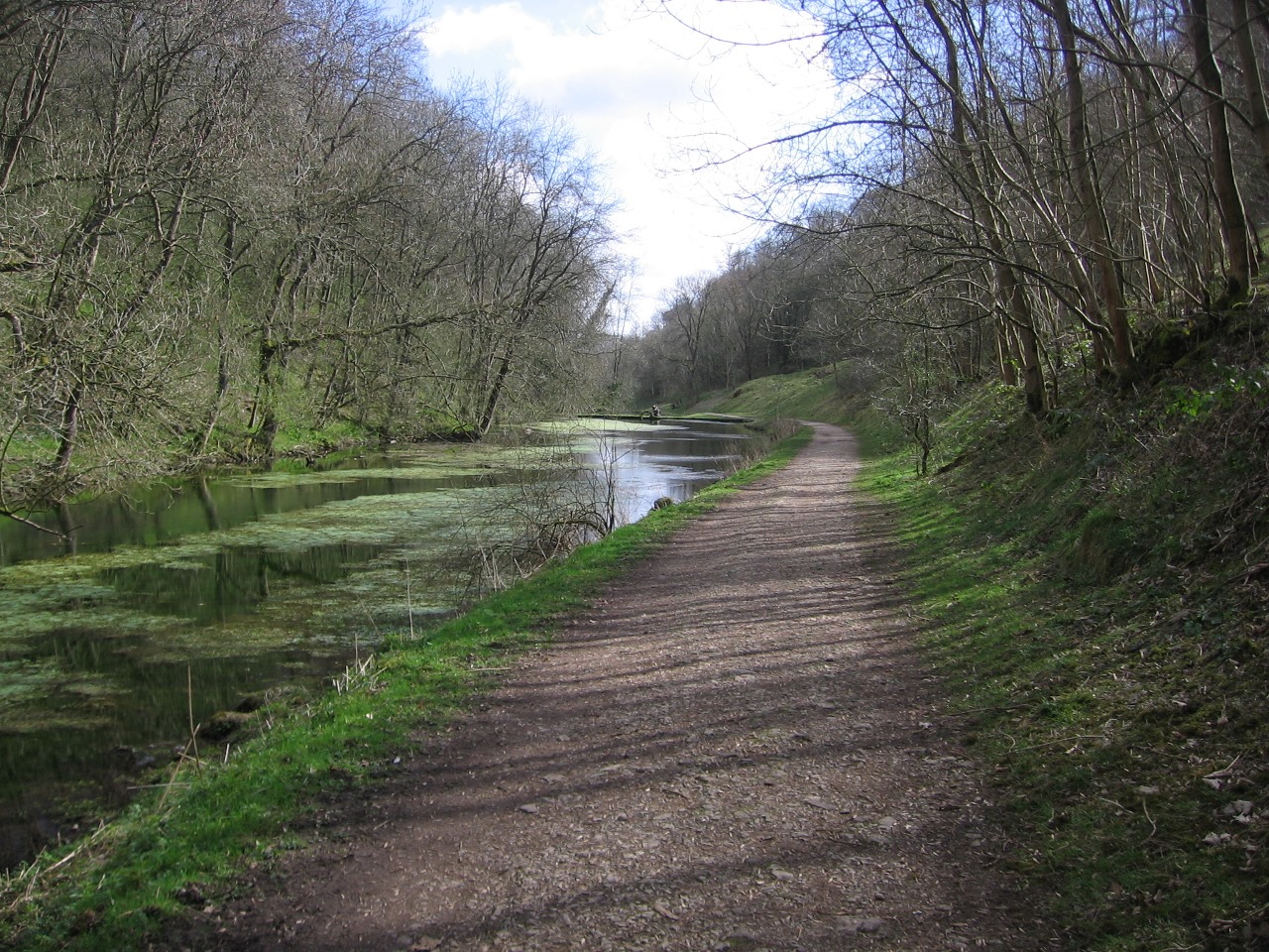
So I dropped down into valley and followed the small river through the delectable narrow wooded valley past the ruins of former settlements in the valley and into the more developed section of the valley where a series of weirs have created lagoons for the aid of fishing. The easy path and sunlight shining through the trees combined to make this a most refreshing section of the walk. I had passed this way eleven years ago while completing Walk 28 from the guide book, but I remember at that time being a little distracted by my uncomfortable, cheap walking boots. I had no such problem this time as I wasn’t wearing boots, but a pair of multi-activity shoes that I now always wear for easier walks off-mountain. While I followed the river below the village of Youlgreave the valley opened out before joining the River Lathkill at the village of Alport. Here I followed the River Lathkill upstream into, perhaps, one of the most popular and spectacular stretch of dales in the Peak District, the beautiful Lathkill Dale Nature Reserve.
 The early section of the walk passed a series of weirs before entering a long, narrow, wooded valley that was ablaze with many varieties of plants and animals. This was a lovely walk through a really peaceful and calming valley that seemed to go on forever with little trace of human interference in the scenery besides the path. As lovely as the riverside walk was, it doesn’t compare, for me, to being at the top of a mountain with the overhanging trees giving the scene rather a claustrophobic feeling so it was with a trace of relief when I eventually emerged from the wood. The scene now changed from one dominated by trees to one where rock was in abundance and I had a smile on my face. I was now skipping from boulder to boulder along the valley floor, where the river had vanished underground (a common occurrence in the Peak District), passing caves and the remains of old quarries to finally reach the end of the valley. Turning almost 180° around I climbed a track that skirted the southern edge of the valley before turning south towards One Ash Grange Farm. Just past the farm the path descended steeply and, briefly, quite enjoyably down into Cales Dale, before climbing steeply back out of the short valley.
The early section of the walk passed a series of weirs before entering a long, narrow, wooded valley that was ablaze with many varieties of plants and animals. This was a lovely walk through a really peaceful and calming valley that seemed to go on forever with little trace of human interference in the scenery besides the path. As lovely as the riverside walk was, it doesn’t compare, for me, to being at the top of a mountain with the overhanging trees giving the scene rather a claustrophobic feeling so it was with a trace of relief when I eventually emerged from the wood. The scene now changed from one dominated by trees to one where rock was in abundance and I had a smile on my face. I was now skipping from boulder to boulder along the valley floor, where the river had vanished underground (a common occurrence in the Peak District), passing caves and the remains of old quarries to finally reach the end of the valley. Turning almost 180° around I climbed a track that skirted the southern edge of the valley before turning south towards One Ash Grange Farm. Just past the farm the path descended steeply and, briefly, quite enjoyably down into Cales Dale, before climbing steeply back out of the short valley.
I was now following the Limestone Way and I would, more or less, stay on this Long-Distance Path all the way back to Elton. The path crossed a number of fields on the high moorland to the south of Lathkill Dale before reaching the car park where I had started my walk eleven years ago. I was intrigued to discover that this small car park where I had parked for free eleven years ago was now ‘pay-and-display’. I had some satisfaction in walking past the car park and taking a track that gradually descended the hillside, dropping back down towards Bradford Dale. Eventually I reached the bottom of the valley once again, but the valley was now not so bright as it had been in the morning as grey clouds had begun to come over, making the day, and the valley, rather gloomy. To avoid retreading my steps through Bradford Dale I decided to follow a path along the northern bank of the river that soon climbed the steep hillside back out of the valley and into the village of Youlgreave. I had never been to this village before so I was keen to have a look at it, but I found it was rather dead with few shops and those there were closed on a Saturday afternoon. After noting where the Youlgreave Youth Hostel was I dropped back down into the valley and crossed the river, rejoining the Limestone Way as it made its way across grassy fields climbing steeply up onto Harthill Moor.
Rounding Castle Ring, the site of an Iron Age Fort, I followed the path to Robin Hood’s Stride, a collection of rocks that I had glimpsed on my outward journey. Deviating slightly from the path I climbed up to the top of the Stride where I stopped and surveyed my surroundings, especially to the south. It was great to be standing on rock again after so much walking through grassy fields. A little distance from Robin Hood’s Stride was another collection of rocks that are marked on the map as Hermit’s Cave. When I investigated I found the top had better views than from the Stride and a cliff face that was so high and steep it was enough to give me the shakes. It is a pity that the cliff is surrounded by trees as it would an awesome sight from all around if it could be seen clearly. Returning to the path, I followed the Way back into Elton where I wearily walked through the village, past the old hall that used to be the youth hostel and back to my car. This walk, although tiring at the end, epitomised everything that the Peak District is best at: spectacular narrow valleys and high, open moorland. This was a great walk to get me into form for the Pennine Way, but it didn’t give me the enormous satisfaction I get from climbing a high mountain. For that I would need to look outside of the Peak District.
