Thursday 28 July 2022

West Highland Way: Kinlochleven to Fort William

Friday 27th May 2022

After starting the West Highland Way at the half way point in Crianlarich, I was now on my third and last day on the trail and although I had not intended on sticking to the trail, poor weather had prompted me to do so. Overnight in Kinlochleven there had been strong winds and heavy rain while I was camped at the Blackwater Hostel, which was so full they were turning people away and many of those appeared to have wild camped in the woods just outside Kinlochleven. I have memories from 2004, when I first did the West Highland Way, of the strenuous climb through the woods out of Kinlochleven, but now as I followed the hordes of people on the trail it didn’t seem too bad. The rain failed to detract from my enjoyment of the views that appeared as I climbed across Loch Leven and back over the trees towards Kinlochleven, but the large numbers of people did spoil the walk as it was often difficult to get around them on the narrow path. Eventually I emerged out of the woods and joined the track that I remembered walking in 2017 after coming down from Loch Coire an Lochain and passing Mamore Lodge. Since 2004 I have returned to this final stage of the West Highland Way several times having done it again in 2012 searching for an easy walk while staying in Glen Nevis and I returned again in the aforementioned walk of 2017.


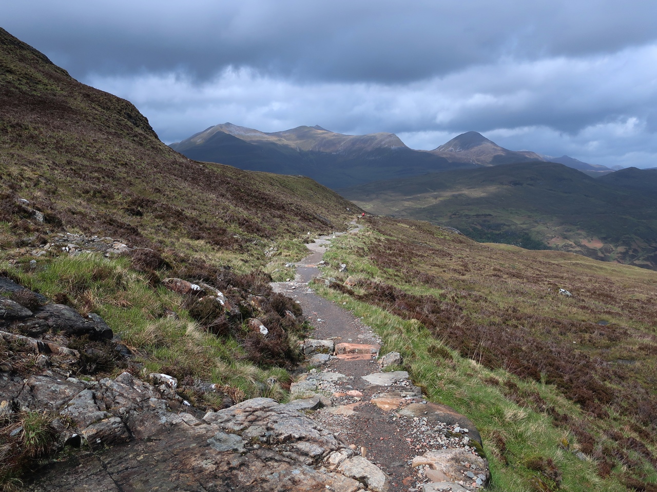
On that occasion I had diverted off the trail towards Beinn na Caillich and Mam na Gualain on a ridge to the south of the West Highland Way and I remember the path down to the bridge over the Allt Nathrach being very muddy, but now I could see that the path has been greatly improved. For this occasion I had planned to come off the trail to climb north on a path into Coire na h-Eirghe, but strong winds and generally poor weather stopped that idea and once again I was forced to stay on the West Highland Way. Unfortunately the trail at this point is very tedious as it follows a wide, stony track through a broad, featureless valley that is empty of any redeeming features. Steep slopes to my right disappeared into the cloud-covered high mountains of the Mamores while to my left was the lower ridge that I had climbed in 2017. There were no trees or buildings in the valley, which was a stark contrast to the beautifully wild landscape around Loch Leven where there are many trees. Slowly, I followed the many other people on the trail over the pass and through the fords that litter the path at that point, which was not a problem for me, but it was funny seeing everyone else trying to cross the streams without getting their feet wet.


After passing the ruins of Lairigmór and the point where my route of 2017 came back down from the ridge, I followed the track as it turned north and entered an area of cleared conifer plantation that is being allowed to regenerate naturally. Eventually I came off the wide, tedious track onto a much more interesting and narrow path that undulates around the hillside and through natural woodland. At one point, in a sheltered ravine over the Allt Coire a’ Mhuilinn, I encountered something I hadn’t yet seen on this holiday: midges. These were very early, but heralded the start of the seasonal invasion of these ‘wee beasties’, but fortunately it would be a while before they would overwhelm everywhere. The path was very narrow at this point, so if someone was particularly slow, then a long queue of people would soon develop behind them and I found myself in one such line, so when I found an exposed location, free of midges, I stopped to have my lunch and admire the view across the former conifer plantation, now a regenerating landscape.


Ahead of me I could see the steep slopes of Ben Nevis disappearing into the clouds while behind me I could see glimpses of blue sky as the sun tried to break through and brighten the day. After eating I continued along the excellent path that descends into the corrie at the head of the valley before climbing up to the pass into Glen Nevis. On reaching a broad forestry road, I knew that the interesting walking was over and also that it was downhill all the way into Glen Nevis, but I was pleased to see that even in Glen Nevis the non-native conifers were slowly being removed and replaced with native deciduous trees. It was just a pity that I had to walk on a wide forestry road, though the views down Glen Nevis towards Fort William were ample compensation as the weather slowly improved. However, I wasn’t in a hurry to get to Fort William so when I reached a junction on the forestry road, I turned right instead of left and followed a branch of the West Highland Way that goes to the Youth Hostel and campsite in Glen Nevis. On previous occasions I have stayed at the Youth Hostel, but I usually find that full of tourists so this time I went to the campsite and put up my tent.

The weather was now sunny and I hoped it would stay that way for the rest of the day, so I got my sunglasses out and went for a walk down the valley towards Fort William, but I didn’t need the sunglasses as the sun didn’t stay out for long and soon it started raining again. I have many happy memories of time spent in Glen Nevis, though the last time I was there was in 2017 so I was glad to be back and enjoy the fabulous scenery. The weather was very changeable during these three days on the West Highland Way so if I had planned to go up mountains on those days, the weather would have ruined everything. Instead, even though I had not intended on staying on the West Highland Way, I enjoyed the experience, but I did not enjoy the vast numbers of people on the trail, which was at its worst on this day. I have increasingly been enjoying long distance trails, especially as they are immune to the weather, and despite only being on the West Highland Way for three days, I really enjoyed it.

Thursday 21 July 2022

West Highland Way: Victoria Bridge to Kinlochleven

Thursday 26th May 2022

At the start of this day I was camped inside a conifer plantation in the valley of the Abhainn Shira and once I had packed up I set off back down the valley under sunny blue skies that had me checking the weather forecast because I had expected rain, which wasn’t too far away. On reaching Forest Lodge near Victoria Bridge I turned left onto the West Highland Way to resume my trek that had started the day before in Crianlarich. Initially the trail passes over cobbled stones that were quite slippery in the damp conditions, but soon became the usual gravely track as I left the trees behind and ventured north across a vast landscape. To my right I had far-reaching views across the bleak Rannoch Moor while to my left rose the high peaks of the Black Mount. When I was previously on the West Highland Way in 2004 I had looked on those mountains with longing, so when planning this holiday I decided to go over them taking in Stob Ghabhair, Creise and Meall a’ Bhùirigh, which is a walk I have wanted to do for a long time. However the weather forecast was poor which prompted me to stay on the West Highland Way and soon it started to rain which didn’t stop until I reached Bà Bridge.


There the sun came out, which gave me fabulous views across Rannoch Moor and up into the mountains that surround Coireach a’ Bà with the narrow ridge, seen end-on, of Sròn nan Giubhas looking particularly striking. I was surprised to see that the mountains were clear of clouds, which made me want to be at the top of them, although the strong winds would have soon taught me otherwise. The sunshine was welcome as I enjoyed the views in all directions while slowly climbing to the pass near Beinn Chaorach where it started raining again. On the descent Buachaille Etive Mór brooded under dark clouds even while Rannoch Moor behind me basked in sunshine. Strong winds attacked me all the way down so when it started raining heavily as I approached King’s House the conditions felt horrible which prompted me and several other walkers to find shelter beside the Inn. I took advantage of the prolonged stop to have my lunch and I didn’t leave until it had finally eased allowing me to set off along the old military road. This stony path took me slightly uphill below Beinn a’ Chrùlaiste and past Buachaille Etive Mór on the other side of the valley near to the top of Glen Coe. It is a shame that the West Highland Way doesn’t descend Glen Coe as that is a delightful valley that I regretted not stopping in to enjoy its delights again.

Instead, I followed the West Highland Way up the infamous Devil’s Staircase as it snakes up the hillside to the highest point on the trail. I remember zooming up this path in 2004 under good weather, but on this occasion it soon started raining again and I was carrying a heavier load (and I was eighteen years older!). After the wide, flat tracks that dominate the West Highland Way, it was great to have a proper mountain path to climb and on the other side I found an excellent path that was a joy to take especially while the sun was shining and I was sheltered from the wind. When I turned a corner at the foot of Sròn a’ Choire Odhair-bhig I was again exposed to the westerly winds, but the views were unimpaired as I rejoiced at the sight of the mighty Mamores range of mountains across the valley and marvelled at how much better the West Highland Way seemed than I remembered from 2004. I was particularly taken by the views into the valley of the River Leven that seemed to be full of trees and made me yearn for Scotland to be more like that. My heart ached for the beautifully wild scenery as I slowly descended onto the access road for Blackwater Reservoir.


The woodland scenery compensated for the wide track that I was slowly descending and so I had a very enjoyable descent all the way from the top of the Devil’s Staircase down into Kinlochleven. Such is the excellence of the signage on the West Highland Way I did not feel the need the consult a map at any time during my two days on the trail from Crianlarich until I reached the River Leven just outside Kinlochleven. I was at a junction, but there was no sign indicating the correct direction. Instead I was confronted by a vast array of adverts for accommodation including the Blackwater Hostel that I had stayed at in 2004. On that occasion I turned left following the sign for the hostel, but the West Highland Way actually turns right, upstream, away from Kinlochleven for a short distance to a bridge, but after crossing over there were still no signs for the West Highland Way. After walking along a road for a short distance I consulted my map and realised I had missed a turning. My Harvey Map indicated that the West Highland Way follows a muddy little path beside the river, but other maps that I have checked since say the road was actually correct.

Eventually I reached the bridge that carries the main road in Kinlochleven over the River Leven and there I finally found a sign for the West Highland Way, but having reached my destination I turned left to go to the Blackwater Hostel that I had stayed in eighteen years ago, although this time I was camping there. Fortunately I had booked two days earlier as the hostel, even just for camping, was full, which is a reflection of the enormous popularity of the West Highland Way. All the time I was on the trail there were people not far ahead of me and others just behind me. I was never on my own, which is one reason why I didn’t need a map: you just followed everybody else.

Thursday 14 July 2022

West Highland Way: Crianlarich to Victoria Bridge

Wednesday 25th May 2022

After several days in Crianlarich and one day later than planned, I set off along the West Highland Way, which is a long distance trail that must be one of the most popular in Britain. My first walking holiday in Scotland involved walking along the trail back in 2004, so it was interesting for me to reacquaint myself with the trail after all those years, even though I didn’t have the best weather. As I left Crianlarich Youth Hostel it was wet and drizzly, which is one reason why I was happy to be keeping to the low ground on the West Highland Way. After passing the railway station, I went under the bypass, which hadn’t been there in 2004, and climbed through the woodland where the trees to my right had recently been felled exposing the trees to my left and resulting in some of them blowing over during the winter storms. At the junction at the top of Glen Bogle, I joined the main route of the West Highland Way, which bypasses Crianlarich, and headed up into a conifer plantation soon getting very hot in my waterproofs. This is a problem with walking in warm and wet weather as despite the claims of many manufacturers of outdoor clothing that their gear is breathable I have found they rarely are, or at least not with the ones that I can afford.

My solution was to put on a wide-brimmed hat, which still kept me dry, but allowed me to cool down. While I was briefly on the West Highland Way two days earlier going south from Crianlarich to Derrydaroch in Glen Falloch, I passed many people coming the other way, but at this point I didn’t see anyone, although I was now going with the general flow of traffic rather than against as before. The rain eased with the gradient and soon I saw some blue sky, which with the isolation within the enclosing wood and a brief opening that afforded with me wider views helped to make this a lovely walk although before too long the trail started to descend and it started raining again. Crossing the raging Herive Burn the walk continued to be enjoyable as I made my way along a narrow undulating path through the conifer plantation that despite being clearly manmade seemed surprisingly wild. I was surprised at how much I was enjoying the West Highland Way. Near the bottom of the hill I came upon an area of felled trees where I was exposed to the wind blowing down Strath Fillan, so when it started raining again my wide-brimmed hat proved useless and had to be removed while I was under the shelter of a railway bridge.


After scampering across the busy A82 road, I crossed the river and the valley floor to reach Kirkton Farm and the remains of St Fillan’s Priory. Although the landscape was now definitely not wild, it is a farm, since the rain had stopped and sun was attempting to come out, I felt good to be walking and this positive mood kept me going past Auctertyre, under the A82 and beside the river into the delightful Tyndrum Community Woodland. Before leaving the river I stopped to take some pictures of the waterfalls near Dalrigh and tried to avoid a mine vehicle that passed by, which was certainly not there in 2004. It was a relief to come off the Mine Road and onto a good path that passes through fabulous scenery decorated with the yellow flowers of broom. Although I had a map with me, I never needed it as the West Highland Way is very well signposted on excellent paths, so I could just relax and enjoy the scenery all around me while blindly following the paths and the signposts that took me into all the way into Tyndrum. On reaching the village the heavens opened so I sought shelter in the shops where I bought my lunch and some food for the next couple of days.


Once the rain had stopped I set off along the wide, tedious track that climbs out of Tyndrym and initially I had good views into a heavily wooded gorge to my right, however the West Highland Way was now finally showing its popularity with many people in sight both ahead of me and behind as I followed the track into the narrowing valley. The A82 road, the railway and the track were all being squeezed together as we headed north in the improving weather and by the time I reached the top of the pass I was enjoying sunshine and good views north. Soon after the start of the descent the trail came off the track onto a narrow, rocky path that was reminiscent of a mountain trail with all its interest, but soon the West Highland Way drops down under the railway and onto another wide track that lacks interest except for the views down the valley that were dominated by the bulk of Beinn Dorain. A long walk followed against a strong headwind and took me down to the Allt Kinglass river and around the tall slopes of Beinn Dorain to reach the railway station at Bridge of Orchy coincidentally at the same time as a train was stopping there.


In 2004 I had stayed at the bunkhouse that is in the station buildings, but now I kept going down to the bridge over the River Orchy and onto a good path that soon became stony and climbs through woodland. Once again I became hot in my waterproofs, but as I emerged from the wood I was rewarded for my effort with good views back to Beinn Dorain and north towards Loch Tulla. When I reached the top of the pass, over Màm Carraigh, the wind picked up and it started raining again so I had a very unpleasant descent down to the road at the Inveroran Hotel, though by the time I reached the bottom the wind had eased and the rain had stopped. From the hotel I walked along the road passing a popular wild camping spot beside the bridge over the Allt Tolaghan until I reached Victoria Bridge near Forest Lodge where I turned left off the West Highland Way. A short walk along the track beside the Abhainn Shira took me to a conifer plantation where I stopped and under the shelter of the trees I put up my new, lightweight tent. This was an amazing, varied walk with some great paths and some tedious tracks; there were some great views when the sun shone, but also heavy rain and strong winds. The unsettled weather was ideal for walking the West Highland Way and I was really surprised by how enjoyable I found it.

Thursday 7 July 2022

Cruach Ardrain

Tuesday 24th May 2022

My plan for this day was to head north on the West Highland Way and then maybe the next day go up some mountains, however the weather forecast for the next day was poor, so it looked like my best opportunity to go up a mountain was on this day, which I didn’t want to waste by walking on the West Highland Way. Therefore I booked another night at the Crianlarich Youth Hostel so I could do the mountain that I’d planned to do the day before when bad weather had forced me to look elsewhere. This mountain was Cruach Ardrain, which I had previously climbed in 2005, but in poorer weather. I started by walking along the road out of Crianlarich, which was not the route that I had previously taken when I followed Ralph Storer’s outdated instructions in “100 Best Routes on Scottish Mountains” that took me up a horribly boggy gap in the trees above Crianlarich. The recommended route now is to head up a track beside the River Falloch towards Coire Earb and then head up the western slopes to Grey Height and was what I had intended on doing, but that involved retracing my steps of the day before, which I wasn’t keen on doing so when I saw a path that headed into the wood I came off the road.

This soon proved to be a bad idea as first I had to make my way over the remains of felled trees and then after reaching a forestry track I had to avoid two logging trucks, so when I saw a slender path heading up the hillside through a gap in the trees I came off the track and took the path even though it took me onto ridiculously wet ground. Eventually I emerged out of trees, but not in an easy place to reach the top of Grey Height and certainly not where I had emerged from the trees in 2005, so I had to cross below the northern crags until I reached a point where I could gain the clear path that comes up from the River Falloch and was the path that I should have been on. The sunshine that had greeted me at the start of this walk proved to be short-lived as it soon became largely overcast with the weather refusing to be consistently good though it was better than the day before. After passing over Grey Height a ridge developed that passes over craggy ground and made me thankful that I had stayed in Crianlarich to enjoy a clear path up a great mountain. I was mindful of the fact that on my holiday in 2005, when I had previously climbed this mountain, I didn’t have a camera, so I was keen to take plenty of photos to illustrate not just this walk, but also the ones that I did in 2005.


While still on the ridge, it started to rain for a short time, but this didn’t bother me too much as there wasn’t much wind which had been my biggest problem the day before with the weather. I was happy to be making my way along this ridge while around me were clear views towards Cruach Ardrain and across the valley to the other mountains that I had climbed in 2005 including An Caisteal, which I had climbed the day before. After passing over Meall Dhamh, the bulk of Cruach Ardrain appeared before me looking impregnable while my path seemed to agree as it veered across the steep western slopes reluctant to attempt the climb. Eventually the clear path peters out to meander faintly up the steep slopes on a tiring climb that was compensated by the great views around me until eventually I reached the southern slopes of the mountain and the clear path that comes up from Beinn Tulaichean. In 2005 I had deliberately made my way across the saddle to bag this Munro, but I had no such desire now, so I turned left to head up to the top of Cruach Ardrain, just as the weather began to worsen again. Therefore I sought shelter on the southern slopes below the summit and had my lunch while it rained again, though the views south remained throughout.


By the time I had eaten the weather had cleared so that from the summit cairn I had tremendous views in all directions which prompted me to cross the summit plateau to take many pictures of the awesome views including west towards the Glen Falloch Group and south towards Beinn Tulaichean. Dark clouds lingered east atop the highest peaks in the area, Ben More and Stob Binnein while north up Strath Fillan there was still rain, though the views up the broad valley were still great. My onward progress was north east down what appeared to be a sheer cliff face, but since I remembered it as being the route I took in 2005 I looked for a path and found a faint, eroded path that weaves very steeply between the rock outcrops. I descended the steep hillside very slowly keeping my centre of balance as low as possible carefully making my way down and concentrating all the time until eventually I thankfully reached the craggy, complex bealach at the bottom where a faint path led me around the crags of Stob Garbh avoiding any unnecessary ascent before finally bringing me up to the summit of this Munro Top. Although the sunshine now held for the rest of the day, it was quite windy on this ridge, which unfortunately detracted from my enjoyment of it similar to the day before.

From the summit I had great views down Strath Fillan towards the dark clouds that remained in the distance as I slowly started to descend the ridge that gradually broadened to became more grassy and dull until eventually I reached the fence that marks the edge of the forestry plantation. I remembered that there is a steep descent beyond this fence so to avoid it I turned right keeping to the top of the ridge, but soon this also started to descend steeply and brought me into an area of dense, young conifers that was almost impossible to battle through until finally I came onto a forestry track that provided me with an easy return to Crianlarich. I was so glad that I was able to do this walk and that my plans had not been so rigid as to prevent me from making the most of the sunshine. Despite weather that was not the best with rain showers in the morning and strengthening winds in the afternoon, I was still able to climb a great mountain with some gorgeous craggy terrain that was a joy to be walking amongst. I do not have many opportunities to be at the top of a Scottish mountain in good weather so I was frustrated the day before not to have such an opportunity, but this day more than made up for that with a great walk up a Scottish mountain in good weather.