Wednesday 28 December 2022

Offa's Dyke Path: The Clwydian Range

Thursday 1st September 2022

Near the end of my walk the day before, while coming down through Llandegla Forest, I could see ahead of me the line of hills known as the Clwydian Range and I was excited about the prospect of walking over them. First thing in the morning, under overcast skies, I set off from the Llyn Rhys campsite through the village of Llandegla and along the Offa’s Dyke Path through grassy fields, which may not have been an inspiring start, but I was excited just to be walking again. One thing I have loved about this holiday is being able to walk every day; the weather was not a barrier to my walking at any point, so I was heartbroken to realise that I was almost at the end of my holiday. Not being able to walk long distances every day almost feels claustrophobic to me. Eventually the terrain began to steepen and I reached a road near to the southern end of the Clwydian Range. The Offa’s Dyke Path misses out many of the tops on the Clwydian Range and begins by crossing the eastern slopes of Moel y Waun. When I came off the road I took a wrong turning so when I realised my error I had to turn around, back to the road and take the correct track past a radio mast and steeply up Moel y Plâs through scorched, yellow grass and bracken.


During my climb up Moel y Plâs the sun began to come out and I had good, though hazy, views to the south and the views north, when I reached the top amongst heather, revealed the continuing range of the Clwydian hills and, as I crossed the western slopes, I had extensive views west across the Vale of Clwyd towards the distant Snowdonia National Park. Offa’s Dyke Path kept to the western slopes as I skirted around Moel Llanfair and Moel Gyw, which meant the western views were constantly drawing my eye while the path provided me with easy walking, maintained the contour around the hills. The vegetation on Moel Gyw was very colourful with the yellow of gorse, the red of bilberry and the purple of heather while the green of bracken provided the backdrop. Eventually I descended to the A494 road at the lowest crossing on the Clwydian Range, but soon branched off the road onto a farmer’s track that skirts around the eastern slopes of Gyrn. After crossing the grassy slopes of Moel Eithinen I began to climb the steep slopes of Moel Fenlli whose banks were also covered with many colourful flowers. Moel Fenlli is the second highest peak on the Clwydian Range, one of only two to reach above five hundred metres, but the Offa’s Dyke Path skirts around the western slopes, so I came off the trail and dragged myself all the way up to the summit of the prominent top.


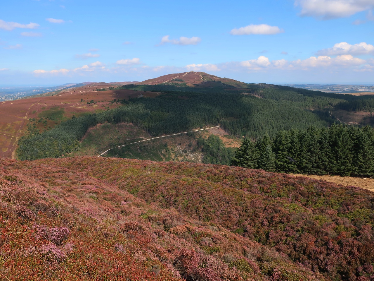
There I found a good-sized cairn and a brisk wind and also great views towards the highest point on the range, Moel Famau. After descending the steep slopes on the other side, down to the busy car park for Moel Famau Country Park, I joined the many tourists ascending the wide track across the western slopes while enjoying the fabulous west towards the mountains of Snowdonia far in the distance. Later, I came into the cold, easterly wind as I slowly approached the summit, all the way up to the Jubilee Tower, constructed at the top of the hill. There I had extensive views in all directions that included industrial Deeside to the east, west across the Vale of Clwyd and north along the gradually descending range of hills that fell all the way down to the sea, which was now clearly in view. Offa’s Dyke Path now kept to the top of the range as I sailed through a sea of gorgeous purple heather while the views under clear blue skies continued to amaze me and the brisk wind accompanied me all the way down. The undulating path passed by a cairn, over Moel Dywyll and towards Moel Llys-y-coed before a steep descent brought me down a heavily-eroded path to another road.


Wearily, I skirted the eastern slopes of Moel Arthur and after another descent to another road I had another climb up to the top of Penycloddiau. It was now quite hot and I was exhausted from the constant climbing along the undulating range of hills. While sheltered from the wind on the western slopes the sweat was pouring off me, so it was a relief to emerge into the easterly winds where I had a chance to cool down. I was mindful of the fact that Penycloddiau was the last peak on the range that I would be going over, so I lingered on the windswept, northern slopes to take in the view before me that now also included the county town of Denbigh before finally descending onto a track that took me all the way down into the valley of the River Wheeler. When I reached the village of Bodfari I waited for a bus to start my journey back to the campsite, which arrived earlier than I expected, so I was lucky to see it and the driver stopped for me. Although the weather was amazing on this walk, it was also a lot windier than I had previously been enjoying on this holiday, however I can’t complain. The views were epic on a great walk that may have completely worn me out, but it was an awesome walk and definitely the climax of the holiday.

Thursday 15 December 2022

Offa's Dyke Path: Pontcysyllte to Pen-y-stryt

Wednesday 31st August 2022

After a very cold night I woke to sunshine and an eagerness to be going, so soon after eight o’clock I set off from the Llyn Rhys Campsite along the Offa’s Dyke Path. I had been walking along this trail in a northerly direction for a week and a half by this point and the previous day on the trail I had reached the Pontcysyllte Aqueduct so to continue I needed to get back there. A direct route took me over Ruabon Mountain while the trail goes around, but first I needed to get over Cyrn-y-Brain and the Offa’s Dyke Path was the best way to do that. Therefore, in Pen-y-Stryt, I picked up the trail and followed it up the hill, through the conifer plantation of Llandegla Forest where a signpost was missing, but I soon realised and retraced my steps to the junction that I had missed and eventually reached the top. Leaving the plantation, I entered a vast moor that was covered in heather and bilberry accompanied by the frequent squawking of grouse as they flew off when I approached. The sunshine that I had woken to was soon gone as clouds began to cover the sky, but this would only be temporary and soon I was enjoying sunshine again on this holiday. Eventually I reached a narrow road that the Offa’s Dyke Path follows for more than a mile, but at the first hint of a path on my left I turned off the road to climb over Ruabon Mountain.


The ground cover on this hill was more mixed than earlier with bracken and gorse adding to the kaleidoscope of colours, while towards the Dee Valley were fantastic views, particularly in the direction of Maesyrychen Mountain. After passing over the top of the hill I descended into a wood where a narrow footpath took me through the valley of the Trefechan Brook to Top Reservoir, which was almost empty, and where I branched off onto a network of footpaths that took me through many grassy fields to reach the village of Trevor, however, route finding was almost impossible. Any paths that I did come across were not actually right-of-ways and they led me astray. Sometimes there were multiple stiles or exits from the fields and once I took the wrong one. And eventually I reached a field that was completely overgrown with thistles and bramble, so despite having a right-of-way it could not be traversed and I had to find a way back out and onto another way down the hill. This diversion took me into the delightful wooded valley of the Tref-y-nant Brook and eventually I successfully managed to traverse the maze and reach the village of Trevor.


At Trevor Basin, I stopped beside the canal to have my lunch before setting off along the towpath to resume my walk on Offa’s Dyke Path, soon branching off to climb up to a road and towards Trevor Hall. The trail continues through adjacent woods for a great walk that was very relaxing despite some deceptive signposts and eventually I emerged to great views along the Dee Valley and towards Castell Dinas Bran. Unfortunately, the sun had chosen this moment to go in so the views were not as good as they could be and it would take a while for the sun to emerge again. Soon, I climbed onto a road that I stayed on for a long time as I crossed the steep slopes below Trevor Rocks on a Panorama Walk that slowly took me past stunning views of the Dee Valley and past the detached hill whose summit is topped by the ruins of Castell Dinas Bran. Once I was past the hill the sun came out again to show off the valley at its best, but I was now becoming more mesmerised by the steep hillside ahead of me, decorated by the rocks of Creigiau Eglwyseg. Eventually I came off the road to take a fabulous path that crosses the steep slopes in truly mountainous surroundings.


I had been looking forward to this point in my holiday for a long time and the superb path did not disappoint. I crossed the rocky gulch above Bryn Goleu onto scree slopes that were thrilling to traverse below serrated crags with awesome views into the Dee Valley and blue skies overhead. I love narrow terrace paths such as these that traverse steep slopes on rocky ground and the delights continued for a long time. After passing below Craig Arthur and Craig yr Adar rock was eventually replaced with bracken and woodland and I reached World’s End at the head of Eglwyseg Glen. Rejoining a road I climbed up onto the moorland top and back onto the route that I had taken at the beginning of the day to retrace my steps over the flagstones that easily led me through the moorland to the conifer plantation of Llandegla Forest and back to my campsite. This was an epic walk through stunning scenery. Apart from the fiasco descending through the fields to Trevor, this walk was a dream that included a colourful moorland crossing, some good woodland walking and a glorious traverse of the crags below Eglwyseg Mountain on paths that are reminiscent of those in the Lake District, and there is no greater praise.

Thursday 8 December 2022

Offa's Dyke Path: Oswestry to Pontcysyllte

Tuesday 30th August 2022

After missing out many miles on the Offa’s Dyke Path as it crosses the plains of the Severn Valley, I was keen to pick up the trail again at the earliest possible point and the best way to do that was to use a bus, so I parked in the long stay car park for the Pontcysyllte Aqueduct and caught a bus to Oswestry. The first thing that I needed to do was find a toilet and the second was to find some drinking water as I’d forgotten to fill up before I left the campsite. Public toilets were easily found but there was not a drinking water tap there, which was really frustrating, so I walked out of Oswestry without filling up with water (I refused to buy bottled water). The Offa’s Dyke Path is more than two miles from the centre of Oswestry so, using my not very helpful Harvey Map of the trail and Google Maps, I followed the correct road out of Oswestry and through the delightful parkland of the Llanforda Estate where grand old trees stood proud amongst the grassland. Eventually I reached Candy Woods where I soon came across Offa’s Dyke Path and turned north to steadily climb along a broad path with a steep drop to my left into the Morda valley below and the ancient earthwork of Offa’s Dyke to my right. This was a lovely walk through woodland that was being shown at its best by the dappled sunshine of another day of fabulous weather.


I had planned to walk through these woods the day before, on one of a number of short walks planned that, except for Llanymynech Rocks, were all abandoned in favour of spending a few more hours in the Shropshire Hills, so it was great to be able to find a way to incorporate them into my schedule. At the end of the wood was an old racecourse, although there is very little of it left now as it is long time since abandoned, but harebells decorated the site and it was pleasant walking. All too soon I came onto a road that I was forced to walk along for far too long and things didn’t improve afterwards as I walked through grassy fields with the dyke alongside. My tedium was caused by the uninteresting terrain underfoot and views that were heavily restricted with the best being a long distance away, far to the east across the plains of North Shropshire. The trail improved slightly as I climbed Selattyn Hill, but avoided the summit although an information point directed me towards the tower that sits at the top of the hill. I resisted the temptation and kept to the trail heading back down the hill along a green lane with tantalising views north. After crossing the Craignant valley and climbing the hill opposite my views now included Chirk Castle and also the extensive but tedious Cheshire Plain.


I felt I was walking on the edge of upland, while the rather flat countryside of England was just to my left and I wished I could see to my right into Wales where there must be lovely hills, but the terrain just rose to higher hills that blocked my view. The Offa’s Dyke Path was keeping to the Welsh border at this point, but when I reached the bottom of the beautiful valley that carries the River Ceiriog the border turns east to follow the river. The trail crosses the border many times while on its course north from the Severn Estuary to the Irish Sea, but this was the last time it crossed the border and from now on the trail stayed in Wales all the way to the sea at Prestatyn. The official route of Offa’s Dyke Path turns left after crossing the valley but a summer variant climbs the hill to reach the National Trust property of Chirk Castle. I was not interested in visiting the castle so after climbing up to the top and taking a look at the extensive views north I headed down the driveway north, but I should have gone west so when I realised I turned left at a crossroads to reach the car park where I was able to take the correct path through parkland to reach a road and the official route of Offa’s Dyke Path.

The official route may actually be better, especially in spring when wildflowers can be seen in the woods, but from this point on I had a rather tedious walk along roads and occasional paths as I slowly descended into the Dee Valley. After crossing the busy A5 road I walked alongside Offa’s Dyke for the last time on the Offa’s Dyke Path before reaching the Shropshire Union Canal (Llangollen Branch). I now had a pleasant walk beside the canal through Offa’s Dyke as it drops through the canal and down to the River Dee, and continues north passing just to the west of Wrexham while the trail heads towards Llangollen. My walk along the towing path of the Llangollen Canal took me past Froncysyllte Marina and out to Pontcysyllte Aqueduct. I previously crossed this in 2007 while returning home from Snowdonia. I don’t remember what it felt like then, but it was very scary now, especially while passing the many people who were coming the other way. Although there is a guard on one side, there is nothing into the canal or on the far side and the aqueduct is very high. I am not good with heights and even just taking a picture towards the distant Chirk Aqueduct felt as though I was taking my life into my hands, so I was relieved when I finally reached Trevor Basin on the other side of the valley.


The official route of Offa’s Dyke Path actually takes to the road, descending into the Dee Valley and for those without a head for heights it is much better. At this point I left the trail for the day and walked the short distance back to the large car park where I had left my car. The weather for this walk was fantastic, which compensated for the frequent periods that lacked interest. My main criticism of this walk was a lack of good views with the best being east towards the plains of Shropshire and Cheshire, which were extensive but dull. However, the sunshine made the walk an enjoyable day.

Thursday 1 December 2022

Offa's Dyke Path: Shropshire Hills and Llanymynech Rocks

Monday 29th August 2022

While planning to do this section of the Offa’s Dyke Path I came up with an over ambitious route of over twenty miles but wisely abandoned it in favour of a much shorter walk two day’s previously from Knighton as far as Llanfair Hill where I had bturned around and headed back. However, that was only half way across the Shropshire Hills and after a further look at the map I realised that I had been a little presumptuous when I had abandoned it so I thought maybe my plans deserved a tweak. I had been prompted by a tedious section of the Offa’s Dyke Path south of Knighton over flat terrain on grassy fields, but the map revealed that there is a lot of gradient change on the Offa’s Dyke Path while crossing the Shropshire Hills, so it deserves a walk. After my final night in the beautiful market town of Kington, I drove through Knighton and Clun to the picturesque village of Newcastle in the Clun Valley. I didn’t bother climbing back up to the top of Llanfair Hill to rejoin the Offa’s Dyke Path at the point where I had left it and instead I joined the trail from the bottom of the valley and immediately I was climbing steeply beside the actual dyke while behind me I had views across the valley and towards Newcastle.


The dyke kept with me all the way to the Welsh border on a very strenuous, undulating route that often passed through woodland or along tree-lined paths with many changes in gradient that frequently had me thinking how many more hills were there, but there always seemed to be more to come. I started by traversing the western slopes of Graig Hill and down into the Mardu valley before climbing around Hergan to a col where I was joined by the Shropshire Way. The trail now crossed the many small ridges that radiate from the high ground to the west towards the valley of the River Unk until eventually my efforts were rewarded with a steep descent into Cwm Ffrydd at Churchtown. A steep climb followed that completely wore me out as I dragged myself all the way up to the eastern top of Edenhope Hill where extensive views were now revealed to the north east that included Stiperstones and the Long Mynd. But, to my utter dismay, I realised that I had to it all over again and descend into the upper reaches the Unk Valley and then climb through Nut Wood to the ancient drover’s road of the Kerry Ridgeway and the Welsh border.


Despite the strenuous walking this was a very interesting and exhilarating walk, so I was glad that I had taken the path. From the top of the ridge I tried to get a good view down the Vale of Montgomery and towards the Severn Valley, but despite descending some way this proved to be difficult so eventually I retraced my steps back up to the road. The bright sunshine that had been with me from the start of the walk was now starting to be smothered by clouds so any photographs would not be as good as they had been. I continued retracing my steps along the Offa’s Dyke Path down into the Unk Valley and exhaustingly back up to Edenhope Hill. I didn’t want to have to do all those undulations again so I had a look at the map to find an easier route back to Newcastle, but the Unk Valley couldn’t be avoided. Eventually I reached the road at the top of the hill where I turned right to pass along the crest of Edenhope Hill up to the broad, high ground to the west and avoid the many ups and downs of the trail. I was able to follow narrow, country lanes that minimised ascents and led me all the way back to Newcastle which lacked interest, but at least made for a speedy return under the cloudy skies.

From the Ridgeway the Offa’s Dyke Path descends into the Vale of Montgomery, which despite the constant presence of the dyke seems to be frightfully dull as it crosses flat farmland. The next moment of interest on the trail is east of the town of Welshpool where there is some steep, wooded ground rising to the summit of the grandiosely named Long Mountain. After having lunch in my car I drove north past Welshpool and ignored Long Mountain, even though it might have merited a walk. After passing the Beacon Ring at the summit of Long Mountain, the Offa’s Dyke Path descends into the Severn Valley for an extended section of very dull walking and doesn’t start to climb again until after the village of Llanymynech. As I drove towards the village, the rocks of Llanymynech Hill looked impressive and dominated the view, so I parked in the village of Llanymynech and immediately joined the Offa’s Dyke Path again to head up the road towards the striking rocks that are actually the remains of quarrying. From the foot of the cliffs I already had great views south across the Severn Valley and towards the Shropshire Hills across the huge gap in the Offa’s Dyke Path that I had just missed out.


The trail skirted the edge of Llanymynech Hill through woodland but soon I came across a golf course that annoyingly sits at the top of the hill so I kept to the edge until all too soon the Offa’s Dyke Path turned sharp left to head down off the hill and I kept going around the hill, while trying to avoid the golf course as much as possible. Without a good map, I had difficulty finding my way, but eventually I did find my way back to the rocks and up to the top of the cliff edge, above the old quarry, where I had good views across the wide valley. It was quite nerve-wracking standing on the cliff edge so I soon moved away and followed the path beside the golf course, but I was unable to find a safe way down until finally I came across the right path that descends back down to the bottom. I wish I had more time to explore this area and a better map so that I knew where I was going, but I still had a lot of driving to do, so I returned to my car and headed north again. My original plan for this day had been for a series of short walks from the Offa’s Dyke Path, but this was the only one I did and even that wasn’t as long as planned. The unplanned walk from Newcastle and a lot of driving used up too much of my time this day to do anything more than this short wander around the rocks of Llanymynech Hill, but it was still an enjoyable day.

Thursday 24 November 2022

The Radnor Forest

Sunday 28th August 2022

On my last day while staying in Kington I decided I would turn my attention briefly away from the Offa’s Dyke Path that I had been following on this holiday and my eye had turned west towards the hills of the old county of Radnorshire. The highest point lies within the Radnor Forest, which is an area of upland moorland rising to more than two thousand feet (a forest in this case, and often in England and Wales, denotes an ancient hunting ground). This was not far from where I was staying so I drove from Kington to the small village of New Radnor and parked near the monument. Setting off through the village I took a lane that climbed between a gorgeous line of trees until the gradient eased and I took a path that materialised on my left climbing steeply through fabulous woodland. Navigation was a little tricky as I crossed several forestry tracks, but by keeping a steady progress uphill I eventually found my way to the northern tip of the wood. Near the end I passed through an area that had been felled and provided wild flowers with the opportunity to dominate and gave me a colourful avenue to walk through. After that great start to the walk I emerged onto the moorland where I had hazy views south across the valley and as I continued to climb the views became more extensive, but just as hazy.


Eventually the path eased as I passed through the shallow col on the summit ridge of Bache Hill whose summit, which sports a trig point, lay to my right. I stayed on the track passing over the top and down to a col between Ystol Bach Brook and Cascob Brook whose northern slopes are covered in conifers. I ignored the plantation and took to a track that climbs up to the summit of Black Mixen, which is adorned with a trig point and unfortunately a large radio transmitter. I wisely avoided the transmitter, but made my way to the trig point. The top of this hill is so broad that there were no views possible aside from the heather moorland itself, which at least was in flower. Continuing along the path I came to the edge of Mynydd Ffoesidoes Nature Reserve where I could see an interpretation board inside, but no paths or any way into the reserve. It wasn’t too difficult to climb over the fence and making way through the dense heather I came to the board and read what it had to say. Returning to my path I followed it beside the edge of the conifer plantation and around the top of Harley Dingle with views down into the valley which houses a firing range.


On reaching a bridle path I moved away from the conifers, but soon branched off to head south to the trig point that sits in the middle of the broad top of Great Rhos, which is the highest point in Radnorshire at 660 metres above sea level. In my youth I had the idea that I would attempt to bag all the hills in Wales more than two thousand feet high. I didn’t complete the list, but myself of twenty years ago would have been very happy to have reached the top of Great Rhos as another peak was crossed off the list. There may be other peaks in Wales that I have still not done, but myself of now doesn’t care and it is immaterial that I had just reached the top of Great Rhos. I was just after a good walk. The views to the north and west were a little clearer than they had been south, and I was able to enjoy those views as I made my way across the top of Great Rhos and down the western slopes while the sunshine that I had enjoyed on Black Mixen became smothered in cloud. Soon, I reached a fence that barred my progress and warned of a live firing range ahead, so despite the path crossing the fence and my map indicating that it was safe to do so, I turned right keeping to the side of the fence.

At a fence junction I turned left heading south until I found a clear path that provided me with easier walking while ahead of me the views continued to improve and enabled me to see the Brecon Beacons in the distance. On reaching a bridleway I took that down into Davy Morgan’s Dingle, a narrow valley that was fun to cross, and the delights continued as I passed through an old quarry and along the side of Radnor Range where signs warned of danger. Finally I crossed the stream that comes out of Harley Dingle and around the side of a hill back into the village of New Radnor. This was quite a short walk and I was back at my car by lunch time, which left me with the whole afternoon and nothing to do. When I planned this walk I hadn’t realised it would only last me four hours, but it was an interesting walk up through woodland, across high moorland and down into the spectacular Harley Dingle valley. To fill my afternoon, I decided I would do an unplanned walk somewhere in the neighbourhood and discovered a car park not far away in the valley of Black Brook, so I headed there and parked at the end of a track where notices gave directions to a waterfall that is the main attraction of the area.

However, I wanted to listen to the Belgian Grand Prix on the radio and for that I needed a good DAB signal so I moved quickly away from the waymarked paths onto a track that climbed up a hill and into the grassy fields and broad top of Mynd. I now had a good signal on my radio, but I had no idea where I was. The Radnor Forest was right on the edge of my map and I had just moved off it, so I wandered around aimlessly until I realised I needed to go back down the hill and join a byway that headed north through Cwm Du. Quickly, I made my way back down the hill and, with patchy reception on my radio, along the track until I entered open moorland where I was able to turn off the byway and climb up to the top of Nyth-grug where I was rewarded with a clear radio signal and good views. At the trig point I surveyed my surroundings that included the Radnor Forest where I had walked earlier in the day. To keep high for as long as possible, or at least until the Grand Prix ended, I slowly headed north along the broad grassy ridge veering right to avoid steep ground until I reached a ford across the Mithil Brook at the head of Llan-Evan Dingle. This stream was dry but descended through a stunning rock-filled gorge and I couldn’t resist scrambling through the ravine that felt like an old quarry, but only because it was dry.


This was tremendous fun, but as water started to appear I eventually had to turn around and climb back up through the awesome surroundings to the ford where I took a path that heads towards the Black Brook valley, but this was very sketchy and I kept going the wrong way so I had to battle through thick bracken to reach the correct path. This took me into a conifer plantation where I went wrong again until finally I found the right path into the valley and to the Water-break-its-neck waterfall. This was a magical place filled with vegetation but no water, which enabled me to walk up the rocky ravine until I reached a delectable bowl where a trickle of water was running down the mossy rock face. However, pictures of Water-break-its-neck reveal that this was not the famed waterfall, which was probably downstream and so didn’t have any water. Nevertheless it was worth the effort if only for the walk through the gorge. This second walk required a lot of effort and I gained very little from it, mainly because it was unplanned, but at least I was able to have a walk while listening to the Grand Prix and it was enjoyable enough in that regard. What more could you ask?

Thursday 17 November 2022

Offa’s Dyke Path: Shropshire Hills

Saturday 27th August 2022

After my disappointment with the latter stage of my walk the day before along the Offa’s Dyke Path, I decided to change my plans for this day, which had been very ambitious with a walk of more than twenty miles. Looking at the route, I was afraid it might be through farmer’s fields the whole way, whose monoculture I find to be rather tedious unless the terrain is steep enough to excite me. The Harvey Map for the Offa’s Dyke Path has different colour coding for improved pasture, rough pasture and moorland, and this indicated that beyond the village of Newcastle the land was all farmers’ fields, but there seemed to be more appeal to the section immediately out of Knighton, a market town on the English border that I had reached on the trail the previous day. My change of plan involved catching a bus from Kington, where I was staying, but since this was not due until 10.10, so I had time for a short wander around the area, following the route of the Herefordshire Trail to the River Arrow and then back west, past the campsite and onto the Kingswood Road where the bus stop in the centre of Kington was a short distance away. Once in Knighton I made my way to the Offa’s Dyke Centre where I was able to see some information about the dyke and learn about the efforts being made to preserve the ancient earthwork.

Leaving the Offa’s Dyke Centre, I dropped down through parkland to the lovely valley of the River Teme and crossed into England and the Shropshire Hills, which are really just a continuation of the hills in the Welsh Marches. I was keen to do some walking in the Shropshire Hills so I was glad that I had elected to continue walking along the Offa’s Dyke Path into the Area of Outstanding Natural Beauty, at least for a while. After crossing the railway line and a campsite that at one time I had considered staying in, I started to climb steeply up the hill, which made me very hot as the sun chose that very moment to come out, though most of the morning it would remain overcast. When I mercifully reached the top, I walked through delightful scenery that looked over the Teme Valley and follows the Welsh border, though under overcast skies. The path I was following kept to the edge of the escarpment below Panpunton Hill and soon I was accompanied by the actual Offa’s Dyke as we headed north. After a brief period away from the escarpment, I came back to the edge around the dramatic gouge into the side of the hill that is Cwm Sanaham. Fortunately I didn’t have to descend by much before starting to climb up the other side to the trig point that sits at the top of Cwm-sanaham Hill.


On the descent I lost the path by keeping beside the fence so I had to retrace my steps back to the path, only to lose it again almost immediately afterwards as I followed a thin, sketchy path onto steep ground. Turning around I crossed the steep ground onto the correct, annoyingly clear path that took me down to a house, labelled on my Ordnance Survey map as Brynorgan. After crossing a road I climbed over a short ridge that was very tiring, even though it was small, so when I emerged into the field beyond I decided to stop and have my lunch while sitting on Offa’s Dyke and enjoying the sunshine. On the other side of the field I crossed a delectable wood-covered stream with hardly any water in it and soon crossed another, similar stream that had only slightly more water. It was distressing to see the efforts that sheep were making on this walk to avoid the hot sunshine, finding as much shade as they could even when this was sketchy at best. After passing Garbett Hall I joined a farmer’s track that steadily climbs the hill, which was a painful and exhausting climb in the hot weather. The track follows Offa’s Dyke but keeps away from it, running alongside, and several times crossed the dyke until eventually the gradient eased and I reached the trig point on Llanfair Hill where I decided I had had enough.


The view ahead seemed to be tedious as the trail crosses the broad top of Llanfair Hill, so I turned around and headed back along the Offa’s Dyke Path to Knighton. After many days of long, tiring walks I thought I needed a much shorter walk, so after just 4.7 miles on the trail I was heading back down the hill, but immediately I came off the trail and onto the dyke. The trail used to run along the top of the dyke, but to preserve the ancient earthwork it was moved off and onto the farmer’s track. However, there is still a right-of-way on the dyke so I followed that for the descent and enjoyed the airy feeling of walking along the top of the dyke with the tremendous scenery of the Welsh Marches to my right until eventually I returned to the Offa’s Dyke Path and completed the descent back to Garbett Hall. Normally you wouldn’t want to cover the same ground twice, but on this occasion it allowed me to see where I had gone wrong on the descent from Cwm-sanaham Hill, missing a totally blatant signpost, and also gave me an opportunity to enjoy the fabulous escarpment edge again and now in sunnier weather. It was quite hot on this walk, which didn’t help on the occasions when I was climbing and resulted in me sweating profusely on many occasions, but it was still very enjoyable.


I have not done much walking in the Shropshire Hills before and I wasn’t sure what to make of them after this walk. I like steep terrain and rock, so while, in places, there are steep gradients, unfortunately the Shropshire Hills are lacking in rock. Most of the hills are covered by farmer’s fields and their gradients are a little too gentle, but I did enjoy this short walk. I could have taken a complete rest on this day and not done any walking, but that is not in my nature, so instead I did a short walk of less than ten miles. The views may not have been overly dramatic, but they were lovely in their gentleness and perhaps that is what I needed.

Thursday 10 November 2022

Offa’s Dyke Path: Hergest Ridge to Knighton

Friday 26th August 2022

On the day before this walk I had reached the town of Hay-on-Wye, but to continue my trek along the Offa’s Dyke Path, I thought I’d start at the western end of the Hergest Ridge, so I made my way from the centre of Kington, where I was now staying, past the Church of St. Mary and Hergest Croft Gardens, along Ridgebourne Road and onto the open hillside. Rather than going straight up to the top of the ridge, I followed the wall across the southern slopes of the Hergest Ridge. After the good weather that I had enjoyed the day before on the Black Mountains, the weather had now reverted to the norm for Wales with light rain and overcast skies, which didn’t help with my enjoyment of a path that was tedious on a hill whose gradients were not steep enough to be exciting with the most interest being roused while crossing the stream in Rabber Dingle. With the hazy weather spoiling the views back to the Black Mountains I kept going along the path and by the time I reached the western end of the ridge the weather was slowly improving with the hills of the Radnor Forest further west attracting my eye. I had seen those hills the day before while coming off the Black Mountains so it was disappointing to realise that the Hergest Ridge was as close as the Offa’s Dyke Path would come to these hills.


Joining the trail I turned east to climb the ridge on a wide grassy track with bracken, gorse and sheep much in evidence across the hill. Since before Monmouth the Offa’s Dyke Path had stayed largely in Wales, but now it crossed the border to enter England and swung to the northern edge of the ridge while I headed across the top to reach the rocks at the highest point and the nearby trig point. Returning to the Offa’s Dyke Path I passed a clump of monkey puzzle trees and down the broad slopes back onto Ridgebourne Road and into Kington. I didn’t think a traverse of the Hergest Ridge would take me very long, so I was rather surprised to realise that several hours had already passed by the time I was back at the Church of St. Mary and I was beginning to worry that this walk may be overambitious. Therefore, I cut the corner in Kington down to the Gilwern Brook and steeply up past the edge of Kington Golf Club where direction finding was tricky. I came across an old man who was also confused about the path, so I checked our location and discovered that we had strayed too far west. Returning to the path we climbed up the hill, but soon I left the old man behind and on the fields around Bradnor Hill I repeatedly needed to check my location.


Eventually I reached the slopes of Rushock Hill where I could see a faint path was heading up the hill and a much clearer path crossed the slopes, so I took the easier option, but when I checked my location I found that I had left the Offa’s Dyke Path again, which climbs to the top of Rushock Hill. Since the trail soon comes back down I decided to stay on my easier route, but on Rushock Hill the Offa’s Dyke Path was reunited with something that has not been seen in more than fifty miles: Offa’s Dyke. On the edge of Knill Garroway Wood, I returned to the route of the trail and with the ancient earthwork behind me I descended to a bench near Herrock Hill where I stopped to have my lunch and gaze out across fabulous views into Wales. Ignoring the clear path up to the top of Herrock Hill I crossed the eastern slopes and continued along the Offa’s Dyke Path into the valley of Hindwell Brook where I crossed the border again back into Wales. After skirting the edge of Burfa Wood I came across Offa’s Dyke again but with dull arable fields to my right and the valley to my left. My interest was revived when I entered Granner Wood where harebells decorated the path, but soon it started to rain, which forced me to put my cagoule on as I passed through Hilltop Plantation and slowly down the hill.


By the time I reached the bottom of the hill, in the valley of the River Lugg, the sun had come out so I took my waterproofs off again and followed the path across the valley while enjoying the sunshine and blue skies that I had not seen all day. On the far side of the valley a gravelly track took me up the hill on an unrelenting climb that was exhausting in the hot weather. The hilly scenery of the Welsh Marches compensated for the strenuous climb as I passed over Furrow Hill, but after Hawthorn Hill the scenery deteriorated. I was now getting tired as the miles began to drag on dull, grassy fields while the sun disappeared behind clouds again and I was stuck on broad hilltops with little to see. It was just at that moment that I realised I had lost my walking pole, so looking back through my day I thought back to when I last had it, to the moment when I had taken my cagoule off after the rain, but that was two hours ago, so I couldn’t walk back for it. I hoped I would be able to look for it in the evening, after the walk, but for now I just had to keep going. Earlier in the day I had been very upbeat, but now, with little change in the views and flatter terrain underfoot while passing through farmer’s fields, I was rather depressed about the walk, so I was thankful when Knighton and the valley of the River Teme finally came into view.

The walk ended with a steep descent through Frydd Wood and into the market town of Knighton, but the field walking had already done too much. I was disappointed with this walk as it had started well, over the Hergest Ridge and the steep climb out of Kington was great leading me to a fabulous view beside Herrock Hill, but it seemed to deteriorate after that except for the brief lift of the bright sunshine in the Lugg Valley. The presence of the Offa’s Dyke itself did little to alleviate the tedium. I was deliberately not walking every mile of the Offa’s Dyke Path on this holiday, which was why I had missed out the section between Hay-on-Wye and the Hergest Ridge, but there were clearly other sections that also didn’t merit being walked. After getting some fish & chips in Knighton I caught a bus back to Kington and immediately drove to the spot where I had taken my waterproofs off earlier in the day. Despite a gap of five hours my walking pole was exactly where I had left it. Fortunately it was off the path where no one had seen it and I was able to retrieve it.

Thursday 3 November 2022

Offa’s Dyke Path: The Black Mountains to Hay-on-Wye

Thursday 25th August 2022

The first mountain that I climbed on my first mountain walk was Hay Bluff on the edge of the Black Mountains, however you could argue that I didn’t actually climb it then as I had started from the car park that is only two hundred metres below the summit. To correct that oversight on this walk I would now be starting from the bottom of the valley in the village of Hay-on-Wye from where the top of Hay Bluff cannot be seen due to the intervening low-lying hills. So, without my goal in sight, I set off from the car park, deliberately avoiding the route of the Offa’s Dyke Path that will be my descent route and followed footpaths that ran alongside quiet country lanes until eventually I completely lost the path. After great difficulty passing through a band of trees I reached a road that I decided to stay on and having already climbed quite a way the gradient now eased to give me a gentle stroll that let me catch my breath and cool down. With the Black Mountains now in view ahead of me, I crossed a cattle grid and with the gradient steepening I climbed up to the car park that I had used in 1999 on my first walk in the area. Beyond the car par, the path steepened cruelly for a tortuous climb before eventually I reached the summit plateau not far from the trig point at the top of Hay Bluff.


The day before I had walked along the Offa’s Dyke Path on the eastern edge of the Black Mountains as far as the crossroads between Capel-y-Ffin and the Olcon Valley and I could have taken a roundabout route to either of those places and then climbed up to the crossroads, but it was much easier to just walk along the Offa’s Dyke Path. Hay Bluff is really just the northern tip of an escarpment with vast moorland behind that soon rises again to a point that is more than seven hundred metres above sea level and was the highest point on that seminal walk in 1999, even though it doesn’t have a name. The path leading away from Hay Bluff soon comes alongside the English border and, not long after, the Offa’s Dyke Path, to climb this mountain whose top is so broad the actual summit is impossible to accurately place, though a small pile of stones have been placed at one point that could arbitrarily be considered the summit. It was overcast and not particularly warm during my ascent, but by this time the sun had come out which was affording me with fabulous views east across the many trees of Herefordshire and west across the glorious Black Mountains.


When I eventually reached the crossing there were gorgeous blue skies overhead, so I was happy to stop and have my lunch while admiring the views all around me. Heading back along the ridge I climbed back through the stony ground that I remember with fondness from my previous visits and make me feel as though as I really am walking through mountainous terrain, even though the gradient is gentle. I had not been over this unnamed hill since 2014 so I was more than happy to now go over it twice passing over the 703 metre top that is the highest point on the whole of the Offa’s Dyke Path. With a cold, northerly wind blowing I made my way across the fabulous terrain with spellbinding views to my left across the Black Mountains that is the location of some of my earliest mountain walks which is why I have a lot of affection for the area. The whole area was looking gorgeous in the sunshine and I couldn’t get enough of the experience as it is good weather days like this that keep you going through many days of bad weather. After passing the thief’s stone, Llech y Lladron, I branched off the direct route to Hay Bluff to bypass the top and contour around the eastern slopes of the hill on a route that I had never taken before and I was impressed.


In contrast to the steep climb directly up Hay Bluff, this is a gradual descent that allowed me to enjoy the views ahead across the broad Wye Valley and towards hills in the distance that I hoped would be on the Offa’s Dyke Path, but sadly they are not. When I reached the Gospel Pass Road I followed that for a time before branching off through a meadow full of sheep and covered in their dung where I should have paid more attention to my map as I veered too far to the left and had to correct myself so I could continue following the route of the Offa’s Dyke Path slowly descending into Hay-on-Wye. This was a much better route than the one I had taken up in the morning as it took me along grassy lanes, down steep embankments and beside narrow streams in glorious warm, sunshine to eventually return to Hay-on-Wye mid-afternoon. I had originally planned this walk a year ago to be done at Christmas to also spend some time in the second-hand bookshops in Hay-on-Wye, but it wasn’t possible then and later I realised that I would be doing that walk as part of the Offa’s Dyke Path. I was happy to do it now and loved extending it along the edge of the wonderful Black Mountains all the way to the Capel-y-Ffin crossroads so I could make the most of the fabulous sunshine.

Thursday 27 October 2022

Offa’s Dyke Path: The Black Mountains to Capel-y-Ffin

Wednesday 24th August 2022

After four fabulous days’ walking in the Forest of Dean and the Wye Valley I left Cherry Orchard Farm campsite and drove to the Black Mountains, but between Monmouth and Abergavenny it started to rain so heavily I thought I would not be able to walk in the mountains. However, before I reached Abergavenny it stopped raining, so I turned right at the large roundabout outside Abergavenny and eventually parked at the car park beside the Queen’s Head Inn. This reminded me of parking beside the Dragons Back Inn (now Dinas Castle Inn) in 2019 on the western edge of the Black Mountains, and there is a similar arrangement here where walkers can park beside the inn for a small fee. After donning my waterproofs against the wet weather I set off along quiet lanes, but soon I took off my waterproofs as the weather slowly improved with stunning views behind me that were dominated by the Skirrid, Ysgwyryd Fawr. I was now on the route of the Offa’s Dyke Path again that I had followed earlier in my holiday as far as Monmouth where it was abandoned so I could explore the Wye Valley. Where the Offa’s Dyke Path leaves the nondescript landscape between Monmouth and Pandy I resumed the trail as it begins to climb into the Black Mountains.


I have a lot of affection for the Black Mountains as it is where I did some of my earliest hill walking and it was fabulous to be back. Slowly, I climbed the path that took me through dense bracken past the remains of an Iron Age fort, through a band of gorse and up onto the heather-clad moorland. Despite walking in the Black Mountains on many occasions, I can remember being at this point only once before on the day after my first walk in the area, back in 1999, and that was for a much shorter walk. Now, I passed by my first trig point of the day and then over Hatterrall Hill from where I had great views up and the valley and along the ridge, and in the distance I could see rain, which prompted me to put on my waterproofs, but in the end it missed me and passed to the north. In the valley to my left I could see the ruins of Llanthony Priory, which is where I had parked last time I was in the Black Mountains, in 2020 for the only hill walk that I did that year. With the English border now following the top of the ridge I passed another trig point and reached the 605m top where a path from Llanthony comes in that was the route I took down in 2020, so now I retraced my steps of that walk along the clear flagstone path. I had planned to keep going along the Offa’s Dyke Path all the way to the northern edge of the Black Mountains on Hay Bluff, but eventually I decided that was too far away and that I would descend into the valley at Capel-y-Ffin.


After passing a third trig point on this broad ridge I eventually reached the crossroads where I turned towards Capel-y-Ffin and when it soon after started to rain I took that to be confirmation that I had made the right decision. My waterproofs came back on and came in handy while passing through thick, water-laden bracken on the path down into Capel-y-Ffin. I have many happy memories of this path and relished the views down the textbook glacial valley even though the weather was not great. When I reached the woodland I stopped to have my lunch and cool down before continuing the descent and finally reach a farmer’s road. Not long after joining that I was stopped by a man who wanted to air his views on the environmental damage of mobile phone masts and for some reason I let him talk for more than half an hour. When he eventually left I was able to take off my waterproofs as the sun had come out while he was talking. I turned left at the Nant y Ffin to reach the bottom of the valley and the road where I climbed past farm buildings up to the open country on the side of the ridge opposite the Offa’s Dyke Path. Turning left I followed a path that keeps just above the fence on a route that I previously took in 2000, though I have little memory of it.


The path took me through thick groves of bracken and seemed endless so that on several occasions I lost all trace of how far I had travelled down the valley, which prompted me to check my location, until eventually the path began to climb towards the top of the ridge up a great rocky terrace. After passing around a cove above Ty-cwm I emerged onto the top of the hill onto terrain was now rather flat and tedious, but through swathes of purple heather that decorated the moor. Eventually I reached the crossing of Bâl Bach where I have been several times before, most recently in 2020, but never before had I been to the hills south of the crossing, so now I kept going through the heather to the prominent cairn on Garn Wen and down the narrowing ridge. Unfortunately the ridge was not narrow enough or steep enough to be exciting and the vegetation was not particularly interesting being mainly bracken and young trees. Slowly I made my way along the ridge that seemed to merely prolonging my descent, until eventually I reached a road that delivered me back down to my car. The weather was very mixed on this walk being generally very warm but with bands of rain and some rain merely threatened by dark clouds or in the distance. It was great to be back in the Black Mountains and striding along those ridges again swallowing up the miles and passing through moorland covered in the purple flowers of heather. My primary motivation in doing the Offa’s Dyke Path was to return to the Black Mountains and despite the poor weather I wasn’t disappointed.

Thursday 20 October 2022

The Forest of Dean

Tuesday 23rd August 2022

With a day to spare in the Forest of Dean and Wye Valley before continuing my trek along Offa’s Dyke Path I thought I would revisit the walk that I did in the Forest of Dean at Christmas 2011. This was the only time I had previously been in the area and since it was not at its best then, being mid-winter, I thought a return was worthwhile. A short drive from Cherry Orchard Farm campsite took me through Coleford to the car park near Speech House Hotel where I had parked previously. The drizzly rain that had plagued my previous day’s walk was in evidence again as I left my car and copying my walk of 2011 I headed down the straight avenue of Spruce Ride. The rain soon stopped and after a short distance along the forestry track I came to Speech House Lake, which I remembered seeing on my previous walk. Continuing along Spruce Ride I passed the crossroads formed by an old railway line, now a cycle track, and onto a good all-weather path where previously I remember the ground was very muddy. My 2011 route climbed steeply up to Staple-edge Bungalows, but this time I decided to turn right at the foot of the climb and follow the bottom of the valley, which I found relaxing walking with clear views up and down the valley that included young deciduous trees and a hint of blue sky above.


At the bottom of the path I reached Mallards Pike Lake, which was a lovely place for me to slowly wander around while the sun began to break through the clouds and provided me with good pictures across the lake. Going into this holiday I was feeling very stressed and tired, and it was taking me a while to recover so on this walk I wanted to further that goal by taking my time and absorbing the natural surroundings as much as possible. Standing beside this lake in the sunshine with the trees surrounding I felt the tension slowly unwind from within me. Leaving Mallards Pike Lake I returned to my 2011 route and crossed a road into an area that previously I remembered having few trees, but was now more overgrown, though this robbed me of some of the views. After crossing a road I reached a narrower, more natural, path that was much nicer to walk on than the bulldozed forestry tracks of earlier, but soon I reached another road and after a short walk along the road opposite I reached a turning onto a cycle path that I had taken previously. However, this time I ignored it so I could find something that my map called New Fancy View. At a car park I turned off the road and onto a path that climbed to a viewpoint where I had extensive views across the Forest of Dean.


The sun had been hiding since I left Mallards Pike Lake, but it now reappeared to provide me with beautiful views across the woodland. It was interesting for me to learn that this was the site of New Fancy coal mine and the viewpoint is at the top of the old spoil heap, which I would never have guessed. Returning back down to the car park I made my way to the cycle path and followed that for a while until eventually I reached the southern end of Cannop Ponds. My onward route was north, but soon I decided that I wanted to turn around so I could take in the view from right at the foot of the pond. Eventually I headed north again and followed the shore of the pond until I reached a picnic site between the two ponds where I stopped to have my lunch while the weather varied from rain to sunshine. With the sun shining again and affording me with good views across Upper Cannop Pond I crossed the dam and headed up a narrow path that climbs steeply up the hillside. Since reaching Cannop Ponds I was on the route of the Beechenhurst Trail with posts that marked the route for me, although on occasions they failed and I was left scratching my head as to the direction to take.

After crossing Speech House Road the trail passed into open woodland and completely disappeared. It should have been easy for me to follow as the trail at this point keeps to a right-of-way, but this was also not well signposted so I had to keep checking my location to ensure I was going in the right direction. At one point I missed my turning and had to retrace my steps, but eventually I found my way down to Cannop Brook, past the route of an old railway line, now a cycle path, and up towards the large Beechenhurst car park where large numbers of people were following a Sculpture Trail. Since it was only two o’clock and my walk was almost finished I decided to do the Sculpture Trail myself, so with the leaflet downloaded on my phone I set off along the well signposted trail back up the hill. However, I had a lot of difficulty finding the first sculpture and there were one or two others that also seemed to be either missing or so well blended into the environment that I couldn’t see them. Slowly I made my way around the trail and even though most of the sculptures held no interest for me the trail at least took me through areas of the Forest of Dean that I had not previously seen and the most interesting sculptures were those that hinted something about the industrial past of the area, which is usually very well hidden unless you are told.


The most remarkable sculpture was near the end of the trail, called Cathedral, and featured a large stained glass window hanging from posts in the middle of the wood. After passing the final sculpture I rejoined the route of the Beechenhurst Trail and entered Cyril Hart Arboretum, which contains a vast collection of different trees and was a joy to walk through, so I wish that I had stopped and spent some time exploring the area but instead I passed through and returned to the car park. This was an enjoyable and relaxing walk through wonderful woodland that provided me with exactly the medicine I needed to refresh my spirit. The Beechenhurst Trail is too short for me, so I had extended it using my 2011 walk and even then it was too short, but with the addition of the Sculpture Trail I had a fabulous walk through the Forest of Dean.

Thursday 13 October 2022

Offa's Dyke Path to Monmouth and the Wye Valley

Monday 22nd August 2022

On the third day of my holiday I left Cherry Orchard Farm, where I was camping, and walked down the road back onto the Offa’s Dyke Path. Up to this point, the trail had kept to the English side of the Wye Valley, but at Redbrook the border turns east and so for the first time the Offa’s Dyke Path crosses into God’s own country, Wales. From the road I had a steep climb up a narrow path that bought me the point where I had previously left the trail with the ascent continuing on a farmer’s track past Upper Beaulieu Farm until eventually the gradient eased. The threatened rain held off, which I was thankful for since I didn’t want to be wearing waterproofs while climbing in the warm weather. The views behind me were hazy and poor, so I kept my eyes ahead of me and eventually I reached the top of the Kymin where there is a monument to the Royal Navy, the Naval Temple was built to celebrate the naval victories of the Napoleonic Wars. A short distance from there is the Kymin Round House where there are picturesque views east past the town of Monmouth, but the weather was not helping me as the views very hazy and disappointing.


From the Kymin a fabulous, sunken path descended through Beaulieu Wood and continues down quiet lanes and through orchards to emerge beside a road that took me over the River Wye and into the town of Monmouth. After crossing the Wye and passing under the A40 road I walked through the narrow streets of Monmouth as far as the famed thirteenth century fortified bridge over the River Monnow that is the only one of its kind left in Britain. I have passed through Monmouth many times on my way to the Brecon Beacons, but I had never stopped before, so I was enjoying the opportunity now to spend some time there exploring the town. Beside the Church of St Thomas the Martyr I turned around and crossed the Monnow Bridge again. After Monmouth, the Offa’s Dyke Path passes through a landscape of small fields and minor valleys that did not appeal to me until it reaches the Brecon Beacons National Park, and so, because I could, I abandoned the trail, for now, and headed back through Monmouth to enjoy more of the delights of the Wye Valley. When I reached the river I turned left to follow the route of the Wye Valley Walk and soon I reached St Peter’s Church, Dixton, where a noticeboard mentioned that the church is frequently flooded.


Intrigued, I turned off the path to enter the building and examine the markers beside the pulpit that show how high the floodwaters have reached with one of the highest being from early 2020. I enjoyed having the luxury of being able to explore this church, whereas if I was doing the whole of the Offa’s Dyke Path and needed to complete twenty miles in one day, I wouldn’t have the time for diversions such as this. Further along the path, the valley closed in as the terrain became quite delightful with trees lining each side. Until recently this section of the Wye Valley Walk was closed due to a landslide so I was happy to discover that the path was now open and the point where repairs were necessary was clear to see, where the river turns sharply below steep ground. The path continued through gorgeous woodland scenery while the river passed through the beautiful Upper Wye Gorge and I had a lovely and relaxing walk as the sun tried to break through the clouds, but ultimately it failed and the rest of the day was cloudy. On reaching Biblins Adventure Centre I crossed the wire bridge over the River Wye and on the far bank I stopped to have my lunch.

Continuing along the Wye Valley Walk I followed the course of an old railway, which provided me with a wide track to walk upon past the rapids on the river until eventually I reached the tourist filled developments around Symonds Yat. I previously passed through this area at Christmas 2011 in very poor weather and although it was now much warmer and not so wet, the views were not much better. Keeping to the Wye Valley Walk, I passed the crowds keeping to the side of the river before climbing into the woodland that lines Huntsman Hill. After coming off a track this path is deliciously narrow and tricky in places as it negotiates large, fallen boulders and passes ruined houses before reaching the intact Huntsman’s Cottage where it climbs up the side of the hill. Below Symonds Yat Rock I parted company with the Wye Valley Walk and climbed up to a road, ignoring the rain as I made my way up to the viewpoint on top of Symonds Yat Rock. The rain had been short-lived, but I was very hot from the steep climb so I took my cagoule off and wondered why the weather had to be almost as unkind to me as it had been eleven years before. From there I headed along the top of the rocks to an alternative viewpoint above Coldwell Rocks, but this was more overgrown and not so good.


Turning my back on the Wye Valley I took a path that headed into the woods on a trail marked as Christchurch to Symonds Yat Rock Walk, which I hoped would lead me back towards my campsite even though I wasn’t really in a hurry to get back. I had not been hurrying all day and now I just meandered along the trail through the woodland as the skies tried unsuccessfully to rain. On the outskirts of Christchurch I turned west towards Bracelands Adventure Centre and Campsite where I somehow managed to miss my turning and when I finally checked my location I discovered that I was heading north instead of south, which prompted a hasty turn around back to where I should have turned. When walking through woodland, all you can see are trees, so it is difficult to navigate and you are reliant on the path and signposts, but this one was not clear. Eventually I reached the village of Staunton where I found a path that took me through more woodland, past a limestone quarry and back to Cherry Orchard Farm. The weather was not good on this walk with occasional, though light, rain and overcast skies all day, which spoilt the views, but it was great to be walking all day following the River Wye through stunning scenery.

Thursday 6 October 2022

Offa’s Dyke Path: Brockweir to Redbrook

Sunday 21st August 2022

After spending the night at Cherry Orchard Farm, I set off from the campsite down the road towards the Wye Valley, however, when I became fed up of the road walking I turned onto a track that heads up the side of the hill and onto the course of an old railway. This led me into a delightfully overgrown wood, but all too soon I had to come back down onto the road and eventually I reached the village of Redbrook at the bottom of the Wye Valley, There, I picked up the route of the Wye Valley Walk and headed south under overcast skies, which was a little disappointing after the sunshine of the day before. There were times during the day when the skies darkened and it looked like it was going to rain, but it never did, and there were times when it looked like the sun was going to break through the clouds, but it never did. It was still warm and I really didn’t want to be putting on waterproofs, so I was quite happy with the weather as it was. The route of the Wye Valley Walk at this point follows the course of the old railway line and soon crosses the river into Wales where I stayed on the western bank for a relaxing walk through fabulous woodland until I was near the village of Whitebrook. At that point, the Wye Valley Walk leaves the riverside to climb into Cuckoo Wood, whereas I stayed beside the river with farmer’s fields to my right until I reached Bigsweir Bridge.


Upon crossing Bigsweir Bridge, back into England, I came across a sign for the Offa’s Dyke Path, which directed me onto the alternative riverside route that allowed me to stay beside the river for a varied walk with interesting views including the many houses of Llandogo that decorate the western slopes of the valley until finally I reached Brockweir where I had left the Offa’s Dyke Path the day before. Going into this holiday I was very tired and it was taking me awhile to recover, and I was feeling particularly drained of energy on this section leading into Brockweir but I managed to drag myself along the path and reached the bridge where rather than immediately starting the Offa’s Dyke Path I crossed it, back into Wales, and returned to the Old Station at Tintern, which I had passed through the day before and now I stopped there to have my lunch and a rest. While eating the sun was most successful in breaking through the clouds, but it didn’t last and soon it was overcast again as I returned to Brockweir, back into England, and retraced my steps of the day before, but to prevent unnecessary climbing I turned off the track onto a gloriously overgrown path that keeps beside the Brockweir stream.

Large clusters of the red berries of rowan trees decorated the path and made the diversion that led me back to the Offa’s Dyke Path worthwhile. After crossing the stream a relentless climb along the narrow lanes, tracks and enclosed paths of St. Briavels Common had me sweating profusely as I slowly climbed up to the top of the hill. With no view and no wind to cool me down I was greatly relieved when I finally reached the top and passed through the Hudnalls where I was able to get some vitamin C from the bramble bushes before reaching what appeared to be the top of a cliff-face. A fence directed me right across a boardwalk and then left steeply down through woodland that would have benefited from a view into the Wye Valley, but all I could see were trees and some of those trees had fallen onto the path, which made route-finding difficult, but eventually I emerged from the trees and now, finally, I had a glorious view that revealed the Wye Valley before me and patches of blue sky overhead, though with no sign of the sun.


Soon after this point I managed to lose the path and reached a gate that was clearly not on the Offa’s Dyke Path, so I retraced my steps back up the hill but even when I found what the map claimed was the correct gate, I still could not see any mention of the Offa’s Dyke Path. Confident that I was on the right path, I kept going and reached a National Trail marked signpost that directed me to Bigsweir Bridge, which I had crossed earlier in the day. Now the riverside alternative rejoined the main route and I headed up a busy road before turning left onto a pleasant path through woodland to reach a section of the ancient Offa’s Dyke that lends its name to the long distance trail that I was walking. There now followed an extended stretch of woodland walking through Bigsweir Wood, Cadora Woods and Highbury Wood Nature Reserves, and I couldn’t help thinking that I was not doing this walk at the best time of the year as these woods must look fabulous in the spring when wild flowers are putting on a tremendous display. Nevertheless, even in late summer I had a great walk through these woods and particularly in Highbury Wood where I was walking beside a clear escarpment edge and part of the remains of Offa’s Dyke.


It was great to be walking along this ancient earthwork, but soon I left it behind and I would not be reacquainted with it for many miles. On coming out of the wood I was confronted by a view of the Wye Valley that actually improved as I descended when the old railway bridge came into view, which I had used to cross the river at the beginning of the day. On reaching the village of Redbrook I turned uphill and wearily realised that since I was camped at the top of a hill I would have to climb to get back up there. Leaving the Offa’s Dyke Path just above Upper Redbrook I took a footpath that climbs through uninteresting farmland to the village of Newland and finally returned to my campsite. Despite generally overcast weather on this walk it was warm, which most of the time made for good walking, but didn’t help me keep cool when climbing uphill. The hot summer had left me very tired going into this holiday and now I had just walked for over eight hours, which I had not done since I was on the Isle of Skye at the beginning of June, but there is nothing better for refreshing both mind and body than getting out in the wild. An eight hour walk is the cure for many of my ills and with two week’s walking on this holiday ahead of me I would soon be refreshed.

Thursday 29 September 2022

Offa’s Dyke Path: Sedbury to Brockweir

Saturday 20th August 2022

I have enjoyed doing several long distance trails in recent years, so at the beginning of this year I was idly looking through some maps wondering if I could do a trail across Wales, but the resulting walk was highly ambitious and I don’t think I have enough experience to accomplish it. I was mindful of the fact that I have never done a long distance trail that takes more than a week, so I started looking for something that would be relatively easy, but would take me more than a week and my eye strayed east on the map to the Offa’s Dyke Path. I have walked parts of this trail before, principally in the Black Mountains, and at 177 miles it is the right length. However, as I started planning I came across the problem I often get with long distance trails and that is having to book all my accommodation, which I find to be very tedious and difficult, and also very frustrating as it locks me into a schedule that I can’t change. The distance that I would be walking each day would be fixed and I hate that lack of freedom. In Scotland I am able to wild camp wherever I like so each day I can keep going until I want to stop, whether that is a long way or to cut the day short if that is how I feel, but in England and Wales I don’t have that freedom.

However a part of me really wanted to backpack the full trail so I battled with myself on how to do the Offa’s Dyke Path until a problem with the trains solved my dilemma. Engineering work was planned for over the summer that would prevent me from getting to the start and then strikes by railway workers made me realise that I couldn’t rely on the trains, so in the end I decided to take my car. I spent a very enjoyable holiday three years ago traversing Wales using my car and I was hopeful of recapturing some of that magic on this holiday. I would not be doing every mile of the Offa’s Dyke Path, but instead I would complete most of the trail as a series of round walks or with the aid of buses. Therefore, I drove to the village of Sedbury near the mouth of the River Wye and set off in the rain, which was rather ironic as we had just been through the hottest and driest summer in almost fifty years. Ignoring the route of the Offa’s Dyke Path, I took a track down to the River Severn and crossed the saltmarsh to as close to the estuary as I safely could without getting sucked into the mudflats. Across the river I could the Severn bridges through the misty weather and I was reminded of walking beside the River Forth a year ago. Even though the saltmarshes were very muddy, there were relatively dry paths further inland that I followed along the foot of Sedbury Cliffs.


At the southern end of the cliffs I climbed up to a good vantage point with views across the river and where a rock marks the start of the Offa’s Dyke Path, so turning my back on the River Severn I set off along the trail and across the stream, Slimeroad Pill, where I immediately discovered the remains of the actual medieval earthwork known as Offa’s Dyke. Offa was an eighth century king of Mercia, who is reputed to have built this dyke to defend his lands from the Welsh. There is little hard evidence about the Dyke except for the fact that it exists, so no one really know how long it originally stretched or how it was used. This brief section of Offa’s Dyke was short-lived and soon disappeared as I skirted the edge of Sedbury while the weather slowly improved so that by the time I stopped for my lunch the sun had come out. Eventually I reached the River Wye whose valley is widely acclaimed and I was looking forward to walking through it, but first I had to get out of Sedbury and even then I was frustrated at not being able to get a view of the valley as I passed through narrow enclosed lanes until eventually I started getting glimpses into a disused quarry, now part of Lancaut Nature Reserve.


Soon after passing there I emerged onto an opening above the cliffs known as Wintour’s Leap that gave me fabulous, vertiginous views across a sharp turn in the Wye Valley. It was great to finally get a view of the Wye but this was soon gone as I turned my back on it and followed the trail for a spell of alternating between crossing some fields and walking along a road until finally I left the road behind and entered a wood. There I found Offa’s Dyke again and followed it for a relaxing and enjoyable walk through the woodland, though with hardly any views out of the trees towards the valley. The footpath was well-made and tried to keep away from the dyke so the ancient earthwork can be preserved as much as possible. At the Devil’s Pulpit, I had a view from the rock pillar into the valley with the ruins of Tintern Abbey far below. When the Offa’s Dyke Path finally emerged from the trees, above the side valley of Brockweir, I finally had clear views and when I reached a junction I took the track down into Brockweir on the route of the riverside alternative. At the River Wye, I left the trail and after crossing the bridge I followed the course of an old railway into the old Tintern station.


The Old Station was very busy, so I just made my way past the crowds until I reached the river and followed it on the route of the Wye Valley Walk to the road and into Tintern. I had planned to follow the Wye Valley Walk all the way to Chepstow, but I was very tired and it was much later in the day that I’d originally planned, so I decided to have a look around Tintern, including the abbey, and wait for a bus to take me to Chepstow where Sedbury is a short distance away across the river. When I started this walk in the rain I didn’t think most of the walk would be under glorious sunshine, but that is how the day developed and it was greatly appreciated. I really needed this holiday to get away from the pressures of work and home, so I was glad to finally leave all that behind and not have to worry about it for two weeks. I had just walked eight miles along the Offa’s Dyke Path and I was looking forward to many miles to come.