Thursday 1st September 2022
Near the end of my walk the day before, while coming down through Llandegla Forest, I could see ahead of me the line of hills known as the Clwydian Range and I was excited about the prospect of walking over them. First thing in the morning, under overcast skies, I set off from the Llyn Rhys campsite through the village of Llandegla and along the Offa’s Dyke Path through grassy fields, which may not have been an inspiring start, but I was excited just to be walking again. One thing I have loved about this holiday is being able to walk every day; the weather was not a barrier to my walking at any point, so I was heartbroken to realise that I was almost at the end of my holiday. Not being able to walk long distances every day almost feels claustrophobic to me. Eventually the terrain began to steepen and I reached a road near to the southern end of the Clwydian Range. The Offa’s Dyke Path misses out many of the tops on the Clwydian Range and begins by crossing the eastern slopes of Moel y Waun. When I came off the road I took a wrong turning so when I realised my error I had to turn around, back to the road and take the correct track past a radio mast and steeply up Moel y Plâs through scorched, yellow grass and bracken.
During my climb up Moel y Plâs the sun began to come out and I had good, though hazy, views to the south and the views north, when I reached the top amongst heather, revealed the continuing range of the Clwydian hills and, as I crossed the western slopes, I had extensive views west across the Vale of Clwyd towards the distant Snowdonia National Park. Offa’s Dyke Path kept to the western slopes as I skirted around Moel Llanfair and Moel Gyw, which meant the western views were constantly drawing my eye while the path provided me with easy walking, maintained the contour around the hills. The vegetation on Moel Gyw was very colourful with the yellow of gorse, the red of bilberry and the purple of heather while the green of bracken provided the backdrop. Eventually I descended to the A494 road at the lowest crossing on the Clwydian Range, but soon branched off the road onto a farmer’s track that skirts around the eastern slopes of Gyrn. After crossing the grassy slopes of Moel Eithinen I began to climb the steep slopes of Moel Fenlli whose banks were also covered with many colourful flowers. Moel Fenlli is the second highest peak on the Clwydian Range, one of only two to reach above five hundred metres, but the Offa’s Dyke Path skirts around the western slopes, so I came off the trail and dragged myself all the way up to the summit of the prominent top.
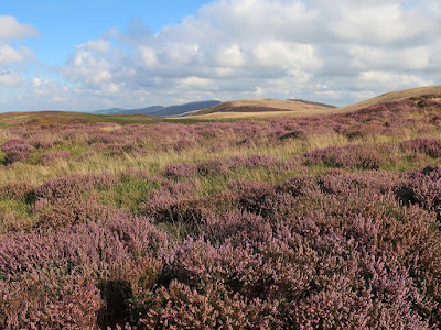
There I found a good-sized cairn and a brisk wind and also great views towards the highest point on the range, Moel Famau. After descending the steep slopes on the other side, down to the busy car park for Moel Famau Country Park, I joined the many tourists ascending the wide track across the western slopes while enjoying the fabulous west towards the mountains of Snowdonia far in the distance. Later, I came into the cold, easterly wind as I slowly approached the summit, all the way up to the Jubilee Tower, constructed at the top of the hill. There I had extensive views in all directions that included industrial Deeside to the east, west across the Vale of Clwyd and north along the gradually descending range of hills that fell all the way down to the sea, which was now clearly in view. Offa’s Dyke Path now kept to the top of the range as I sailed through a sea of gorgeous purple heather while the views under clear blue skies continued to amaze me and the brisk wind accompanied me all the way down. The undulating path passed by a cairn, over Moel Dywyll and towards Moel Llys-y-coed before a steep descent brought me down a heavily-eroded path to another road.
Wearily, I skirted the eastern slopes of Moel Arthur and after another descent to another road I had another climb up to the top of Penycloddiau. It was now quite hot and I was exhausted from the constant climbing along the undulating range of hills. While sheltered from the wind on the western slopes the sweat was pouring off me, so it was a relief to emerge into the easterly winds where I had a chance to cool down. I was mindful of the fact that Penycloddiau was the last peak on the range that I would be going over, so I lingered on the windswept, northern slopes to take in the view before me that now also included the county town of Denbigh before finally descending onto a track that took me all the way down into the valley of the River Wheeler. When I reached the village of Bodfari I waited for a bus to start my journey back to the campsite, which arrived earlier than I expected, so I was lucky to see it and the driver stopped for me. Although the weather was amazing on this walk, it was also a lot windier than I had previously been enjoying on this holiday, however I can’t complain. The views were epic on a great walk that may have completely worn me out, but it was an awesome walk and definitely the climax of the holiday.


No comments:
Post a Comment