Thursday, 14 September 2023

Loughrigg Fell

Saturday 19th August 2023

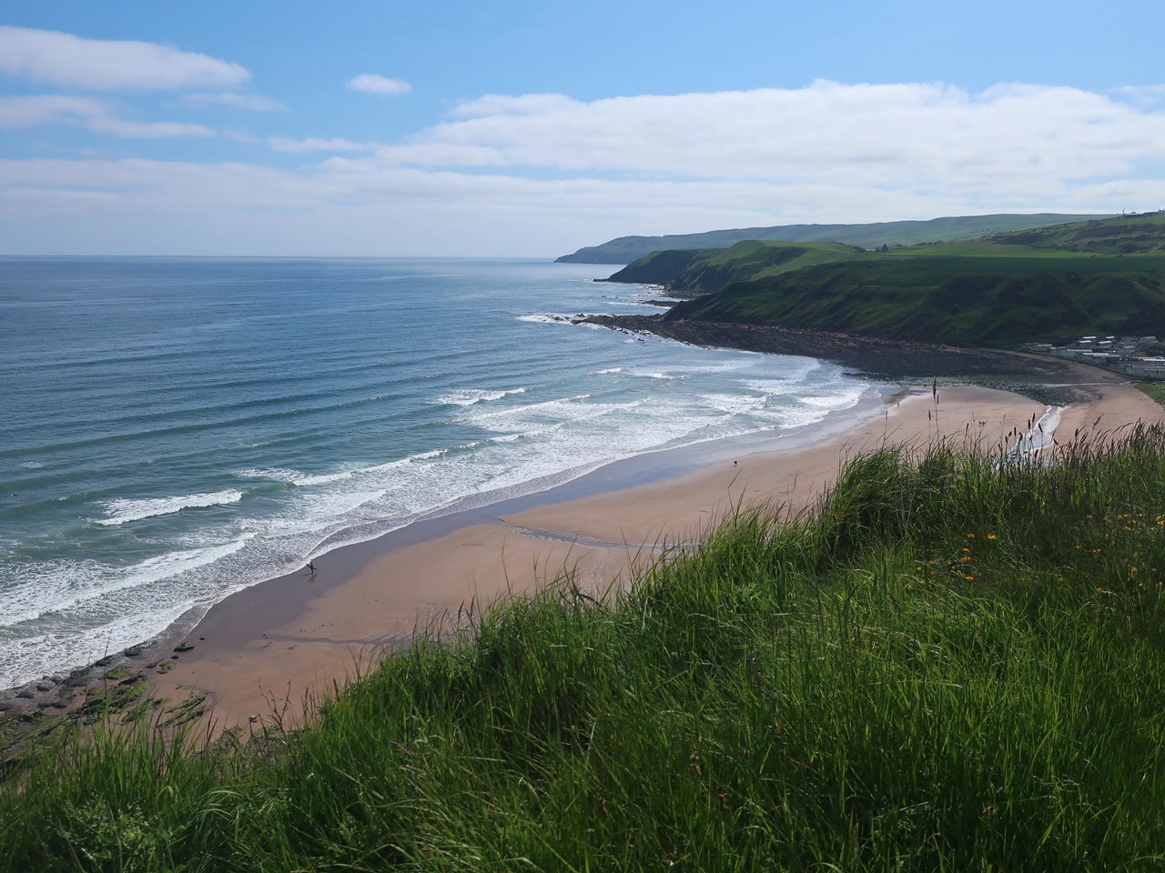
I had hardly done any walking over the summer, since leaving Scotland at the beginning of June, so for my next holiday I needed somewhere I could relax, not push myself too hard and allow myself to recover from the difficulties that I have had this year, and there is nowhere better for that than the Lake District. Part of me would love to spend all the time there, but it is very crowded, which puts me off and I try to stay away so I am not adding to those crowds and the erosion on the fells that they cause. The last time I was in the Lake District for a major holiday was spring 2021 when Covid was still at the forefront of everyone’s mind, which led to me camping every night, but now with Covid, hopefully, a distant memory the restrictions as a result of the pandemic have been largely lifted. Therefore, this is my first chance since spring 2018 to do the Lake District as I used to in the past. I have very fond memories of walking in the Lake District over the last twenty years and a repeat of those holidays is just what I needed to revive my spirits. The train arrived at Windermere station on time, which is surprising, and I decided that I would immediately start walking from the station, even though that is not what I have done in the past when I have always first caught a bus to Ambleside or Grasmere. However, when I was in the Lake District for a couple of days last Christmas, I walked all the way from Ambleside to the station and it didn’t seem too far, though in a little change to my route of last Christmas, I initially headed up the Orrest Head path.


Behind me were many people chatting noisily away, but, thankfully, at the junction where the path up to Orrest Head turns right, I kept straight on along a lovely path with a wall on my left above gardens and woodland on my right. The weather was warm but overcast with a strong wind that was not a problem at the moment, though it would definitely prove a problem higher up. The sun was trying to break through the clouds, but ultimately failed. The path took me into High Hay Wood, which I had a quick look around, but soon I retreated and followed the path out of the wood and onto the Patterdale Road. A side road took me down to the Ambleside Road, which I would follow all the way to Ambleside, but when I reached the Brockhole National Park Visitor Centre I thought I’d have a look around as in all my years of coming to the Lake District I had never been before, but it is just something for the tourists, an activity park for those who are not interesting in walking over the fells, as if anybody would not want to do that. There was nothing for me except somewhere to sit and have my lunch and after eating I returned to the road to resume my walk to Ambleside.

The road was very busy with slow moving traffic that made me glad to be walking and eventually I reached Ambleside where I bought something for my dinner before heading across Rothay Park to Under Loughrigg Road. My overnight accommodation was on the other side of Loughrigg Fell and I could have just walked around, but it was much more interesting to go over the fell even though I’ve been over Loughrigg many times. A look at Wainwright’s guidebook revealed a route up that I’d never taken before so I ignored the bridleway that starts opposite Rothay Park and followed the road beside the River Rothay until I reached Foxghyll where a lovely, little path heads up the side of the hill, initially through woodland and with great views behind me, across the valley and towards the Fairfield Horseshoe. On emerging from the wood the path continued to climb beside the Fox Ghyll stream, passing a bank of bramble that provided me with many tasty blackberries before eventually I reached a shallow depression that Wainwright calls the Amphitheatre and the Ordnance Survey calls Black Mire. I had never been this far into the Amphitheatre before and, of course, it was very wet underfoot. On the other side a steep climb brought me up the hill and I stopped many times to turn around and look at the view across the valley towards Wansfell and the Rydal valley.


Even though the weather was poor, it was great to be back in the Lake District and as I absorbed the tremendous views I could feel the stresses of the year already leaving me. I took my time to enjoy that view and to not push myself to climb the hill quickly, plus at this moment I was sheltered from the strong winds, and when I eventually reached the top of the ridge I was exposed to the full might of Storm Betty. Despite the strong winds and grey skies I had awesome views over Loughrigg Tarn and up Langdale, but I didn’t linger and after taking a few pictures I returned to the main path and followed it across the fell, branching off to visit the windswept south summit before continuing up to the highest point on Loughrigg Fell. I tapped the trig point and hastily continued to the northern slopes, which were a little more sheltered and now afforded me with views across the village of Grasmere with Dunmail Raise pass in the distance. Soon, I branched off the main path down to Grasmere to take a route that I’d never taken before and descends north of Intake Wood. This was very steep, but afforded me with views over Grasmere to the north and west into Langdale with the youth hostel in plain sight. Unfortunately it wasn’t yet four o’clock and the reception at the hostel doesn’t open until five so I had some time to kill. Fortunately the grounds at High Close are quite extensive and I was able to follow a trail through the woodland which provided me with a lovely, relaxing walk until eventually I returned to the hostel. This was a good, gentle walk that helped me to get used to walking again, and with the strong winds I couldn’t really do anything else. 


Thursday, 7 September 2023

Southern Upland Way: The Lammermuir Hills

Thursday 1st June 2023

To finish describing my trek along the Southern Upland Way, I started my penultimate day at a beautiful wild camp beside the Blythe Water at the junction with the Wheel Burn on the edge of the Lammermuir Hills. The previous evening had been sunny, but now I woke to cold, overcast skies and I could feel light rain in the air, so the fabulous sunshine that I had enjoyed for much of the holiday was now gone and the weather was finally feeling more Scottish. A footpath took me over Scoured Rig, and past an area of felled conifers, down to Braidshawrig. The clouds were very low, covering the tops of the Lammermuir Hills, which form a barrier between East Lothian and the Scottish Borders of high heather moorland, but without any significant peaks, though deep-sided valleys penetrate the hills. I had never been in the area before and the Southern Upland Way merely skirts the southern edge and I was not seeing it in the best of weather. However, the heather moorland was a welcome change from the tedious, grassy farmland that I had walked through the day before, even though I couldn’t help anticipating the approaching end of the trail. A track slowly took me up onto the moor through featureless terrain that was still quite enjoyable to walk through compared with the farmland of the day before. Swathes of cotton grass decorated the landscape, along with some sheep, and as I climbed heather became more abundant. 

 
After climbing onto Blythe Edge a word appeared on a trail post that had been exciting me throughout the Southern Upland Way: “ultreia”, which indicates that just beyond is a hoard of specially minted coins hidden in a sculptured kist. Therefore I kept my eyes peeled for the kist and eventually I found it and the slightly rusty coins inside. I was glad to find this kist as I had missed a few recently and I had feared I would not find anymore. Ahead of me were the two cairns of Twin Law so I climbed to the top of hill and explored the two magnificently constructed structures there, complete with porches that include a metal case containing a logbook. After entering my comment in the logbook I turned into the cold wind coming off the sea and headed back down the hill where, if the weather was good, surely I would have had my first glimpse of the sea, but that was not to be. Eventually I reached Watch Water Reservoir where I had my lunch before continuing along a road for an extended plod as the excitement of crossing the Lammermuir Hills was soon over and the rest of the trail descended into tedium.

After passing through the village of Longformacus I climbed toward Black Hill Wind Farm but before reaching the top I turned north and descending into the valley of the Whiteadder Water. The views under the dull, grey skies were mainly of farmland so were not interesting to me, though the conical peak of Dirrington Great Law had grabbed my attention, but mostly I was just counting down the moments until I could finally reach the end of the trail after walking such a long way. On the northern tip of Black Hill I crossed the thousand feet mark for the last time on the trail and I realised that that was the last hill on the Southern Upland Way. A forestry track eventually brought me into Abbey St Bathans which was a delightful place, but completely deserted, so I turned up beside the Wharfe Burn and on the recommendation of the rambling man website, which had recommended the previous night’s wild camp, I stopped beside the path in delightful surroundings for my final night on the trail. My walk over the Lammermuir Hills was enjoyable and had helped me recover from the previous day’s tedium, but after lunch there had been no interest though a little variety prevented the tedium of the day before.

After a peaceful night I set off along the track and immediately climbed away from the Wharfe Burn onto boring farmland which continued over a hill, past Blackburn Mill, until eventually I descended into the valley of the Pease Burn, which contains both the A1 trunk road and the East Coast Mainline. After a death-defying dash across the A1 I discovered a mown path through the undergrowth between the road and railway and eventually crossed the line into Penmanshiel Wood, which is yet another conifer plantation on the Southern Upland Way, but thankfully the last. The last of the hoards of hidden treasure should be in this area, but I didn’t see any sign of the kist that marks the location, though the track beside the river had been recently widened which may have damaged it. The vegetation beside the Pease Burn was lovely with wild garlic dominating but the destruction from the wide forestry track ensured that this was hardly noticed. Eventually I came off the wide track to climb through the plantation for an extended walk among the conifers before finally descending and entering Pease Dean Nature Reserve. 

 
This was a beautiful place, gloriously overgrown, but with still no sign of the sea. I could hear it and even smell it, but the thick woodland prevented me from seeing the North Sea until eventually at the top of a flight of steps the sea emerged above the trees. The path descended into a deep woodland valley and I emerged from the reserve on the edge of a holiday park which I skirted before climbing to the top of the cliffs overlooking Pease Bay with the red rocks of the cliffs further up the coast. It was exciting to be finally at the North Sea after twelve days on the Southern Upland Way crossing from the west coast of Scotland all the way to the east coast. The end was within reach. First I made my way along the top of the craggy cliffs high above the sea and past tiny Cove Harbour which seemed like a fitting counterpoint to Portpatrick where I had started the trail. Even though the views up the coast included the large white building of Torness Nuclear Power Station and the chimneys of a cement works, the views under sunny blue skies were fantastic and spurred me on to complete the last little section of the Southern Upland Way which bizarrely now turned back west towards Portpatrick. 

 
Eventually, after passing under both the A1 and the railway line, I reached the small village of Cockburnspath where an information board on the junction of the Edinburgh Road and road into the village announces the Southern Upland Way that according to the trail website ends at the war memorial opposite. However other sources claim the market cross in the centre of the village is the end of the trail, though there is no acknowledgement of that there. I have wanted to do this trail for a long time, it is something I have aspired to do and now I have done it. There is a lot of variety, many good bits and many bad bits, but almost all of the best bits were in the county of Dumfries and Galloway and I felt the trail started to deteriorate once I entered the Scottish Borders, which is a shame as I’m sure the county has many interesting walks. The highlights on the Southern Upland Way for me were the bluebells in Glen Trool and also in many other places, plus the many ranges of hills and the beautiful wooded valleys. I didn’t mind the large number of conifer plantations but I don’t enjoy walking through farmland and there seemed to be increasingly more of that as the trail reached its last few days. The weather was almost uniformly sunny which is astonishing and more than I could have hoped. As I waited for a bus to start my journey home I was exhausted but pleased to have finally done the Southern Upland Way.