Wednesday 24th August 2022
After four fabulous days’ walking in the Forest of Dean and the Wye Valley I left Cherry Orchard Farm campsite and drove to the Black Mountains, but between Monmouth and Abergavenny it started to rain so heavily I thought I would not be able to walk in the mountains. However, before I reached Abergavenny it stopped raining, so I turned right at the large roundabout outside Abergavenny and eventually parked at the car park beside the Queen’s Head Inn. This reminded me of parking beside the Dragons Back Inn (now Dinas Castle Inn) in 2019 on the western edge of the Black Mountains, and there is a similar arrangement here where walkers can park beside the inn for a small fee. After donning my waterproofs against the wet weather I set off along quiet lanes, but soon I took off my waterproofs as the weather slowly improved with stunning views behind me that were dominated by the Skirrid, Ysgwyryd Fawr. I was now on the route of the Offa’s Dyke Path again that I had followed earlier in my holiday as far as Monmouth where it was abandoned so I could explore the Wye Valley. Where the Offa’s Dyke Path leaves the nondescript landscape between Monmouth and Pandy I resumed the trail as it begins to climb into the Black Mountains.
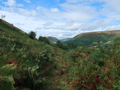
I have a lot of affection for the Black Mountains as it is where I did some of my earliest hill walking and it was fabulous to be back. Slowly, I climbed the path that took me through dense bracken past the remains of an Iron Age fort, through a band of gorse and up onto the heather-clad moorland. Despite walking in the Black Mountains on many occasions, I can remember being at this point only once before on the day after my first walk in the area, back in 1999, and that was for a much shorter walk. Now, I passed by my first trig point of the day and then over Hatterrall Hill from where I had great views up and the valley and along the ridge, and in the distance I could see rain, which prompted me to put on my waterproofs, but in the end it missed me and passed to the north. In the valley to my left I could see the ruins of Llanthony Priory, which is where I had parked last time I was in the Black Mountains, in 2020 for the only hill walk that I did that year. With the English border now following the top of the ridge I passed another trig point and reached the 605m top where a path from Llanthony comes in that was the route I took down in 2020, so now I retraced my steps of that walk along the clear flagstone path. I had planned to keep going along the Offa’s Dyke Path all the way to the northern edge of the Black Mountains on Hay Bluff, but eventually I decided that was too far away and that I would descend into the valley at Capel-y-Ffin.
After passing a third trig point on this broad ridge I eventually reached the crossroads where I turned towards Capel-y-Ffin and when it soon after started to rain I took that to be confirmation that I had made the right decision. My waterproofs came back on and came in handy while passing through thick, water-laden bracken on the path down into Capel-y-Ffin. I have many happy memories of this path and relished the views down the textbook glacial valley even though the weather was not great. When I reached the woodland I stopped to have my lunch and cool down before continuing the descent and finally reach a farmer’s road. Not long after joining that I was stopped by a man who wanted to air his views on the environmental damage of mobile phone masts and for some reason I let him talk for more than half an hour. When he eventually left I was able to take off my waterproofs as the sun had come out while he was talking. I turned left at the Nant y Ffin to reach the bottom of the valley and the road where I climbed past farm buildings up to the open country on the side of the ridge opposite the Offa’s Dyke Path. Turning left I followed a path that keeps just above the fence on a route that I previously took in 2000, though I have little memory of it.
The path took me through thick groves of bracken and seemed endless so that on several occasions I lost all trace of how far I had travelled down the valley, which prompted me to check my location, until eventually the path began to climb towards the top of the ridge up a great rocky terrace. After passing around a cove above Ty-cwm I emerged onto the top of the hill onto terrain was now rather flat and tedious, but through swathes of purple heather that decorated the moor. Eventually I reached the crossing of Bâl Bach where I have been several times before, most recently in 2020, but never before had I been to the hills south of the crossing, so now I kept going through the heather to the prominent cairn on Garn Wen and down the narrowing ridge. Unfortunately the ridge was not narrow enough or steep enough to be exciting and the vegetation was not particularly interesting being mainly bracken and young trees. Slowly I made my way along the ridge that seemed to merely prolonging my descent, until eventually I reached a road that delivered me back down to my car. The weather was very mixed on this walk being generally very warm but with bands of rain and some rain merely threatened by dark clouds or in the distance. It was great to be back in the Black Mountains and striding along those ridges again swallowing up the miles and passing through moorland covered in the purple flowers of heather. My primary motivation in doing the Offa’s Dyke Path was to return to the Black Mountains and despite the poor weather I wasn’t disappointed.


