Continuing the Challenge Walk around Charnwood Forest, from the top of Bardon Hill I returned to the radio mast and walked down the service road taking a footpath on the left when I reached the wide dirt track to walking between the wood and the desolation at the end of the dirt track. These quarries are not like the remains of tiny quarries that one sees in the Lake District or the Peak District as these are modern quarries: huge, horrible places that have made a right mess of the landscape, and are quite depressing. Emerging from the footpath on the edge of Coalville I walked up the hill to a T-junction where I crossed over to an area of rough country marked on the map as the Warren Hills, and is part of the Charnwood Lodge estate. The walk across this small area of unspoilt ground was quite a revelation. I had never been there before, in fact I didn't even know it existed. There were many outcrops dotted around the area and I had an immense desire to climb all over them, but that would have to wait for another day (like Boxing Day when I returned to the area for a play!). Emerging from the open country I walked a short distance along the road before turning left onto a narrow lane that eventually led me to Mount St. Bernard Abbey, which is the half way point of the walk and a convenient place to stop and have my lunch.
After a good rest I started stage three of the walk, which is probably the least interesting stage and also the point where the miles started to take their toil. Emerging from the Abbey driveway I took a footpath opposite down to the picturesque Blackbrook Reservoir and along a track to a road. Now began a prolonged spell of road walking punctuated by short spells across fields, as I walked to a crossroads and decided to go straight across instead of the prescribed turning right that would take me up the hill to the village of Oaks in Charnwood. This diversion seemed pointless as I would then have to come back down the hill again to this same road, so staying on the road saved me a lot of energy just at a point when I felt I had none left. Soon I turned into Lubcloud Farm and climbed over the hill down to a road (the B591) and passed under the M1. Another long stretch of road walking saw me go down a hill and up again as I climbed towards Beacon Hill.
 At the Rippin Memorial Walk near Beacon Hill I turned left onto a pretty avenue of trees as I wearily climbed up the hill to the top of Beacon Hill (at 248m), which is a fantastic place that I have visited many times in recent years, but now I was so weary I just found a chair and collapsed into it, and ate something to get my strength back. Eventually I felt refreshed and able to resume the walk down the hill through the woodland to the lower car park where I diverted from the prescribed route which would have required another walk along the road and instead I walked through the park straight to the Broombriggs car park. The prescribed route bypasses the top of Windmill Hill but with most of my strength back after the rest I rushed off up the hill to the remains of a windmill that gives the hill its name. Heading steeply down the hill I walked into the village of Woodhouse Eaves where I found my first shop in 18 miles which was able to resupply me with liquid refreshment. The onward route passed close to the local school and onto fields where I believe I made another mistake. The directions told me to turn right through a gate by the school but I must have gone straight on, however I didn’t realise my mistake for a while.
I still emerged onto a road as I was supposed to, but there was no path directly opposite, however there was one a short distance away so I took this as it seemed to be heading directly for Rushey Field Farm. However, this should have told me something was wrong as the path I should have been on passes to the north of the large farm. When I found a junction of paths I was puzzled as the Leicestershire Round that I thought I was on was actually crossing my path. My compass also failed to tell me what I had done wrong because I still hadn’t realised that I had earlier gone wrong. Eventually I decided to turn right as required but since I had approached on the wrong path I was now in fact taking the path I should have taken from Woodhouse Eaves. When I reached a lane, the same lane I had crossed earlier, now sporting a footpath directly opposite I realised my mistake.
I could have turned back and returned to the junction of paths but I really couldn’t be bothered. I was tired, I was near the end of the walk and it was starting to rain heavily. After walking along the road past the Brand I took the second turning on the right and soon entered Swithland Wood to walk back to my car in the pouring rain. At least I made it back to the car with plenty of daylight remaining, which was one consolation from the walk, as walking on the shortest day of the year may have made things rather difficult if I hadn’t kept up a quick pace. This was obviously a challenging walk that really tested my stamina in the latter stages, however I don’t think it was really that difficult apart from the distance and in better weather it may have been quite fun. Maybe I should repeat the walk in the spring, for now I’m just glad I managed to get around it.

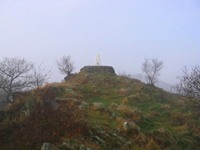 At the top of the hill is a big radio transmitter, and a short walk along the summit ridge brought me to the trig point, and not far from that is a huge fence while beyond the fence, barely discernible in the mist, is the huge Bardon Quarry. Bardon Hill may be the highest point in Leicestershire (at 278m) but Old John and Beacon Hill (seen later) are much more satisfying hills and they have not been exploited. More in my next post...