Thursday 29 June 2023

Southern Upland Way: Clatteringshaws Loch

Wednesday 24th May 2023

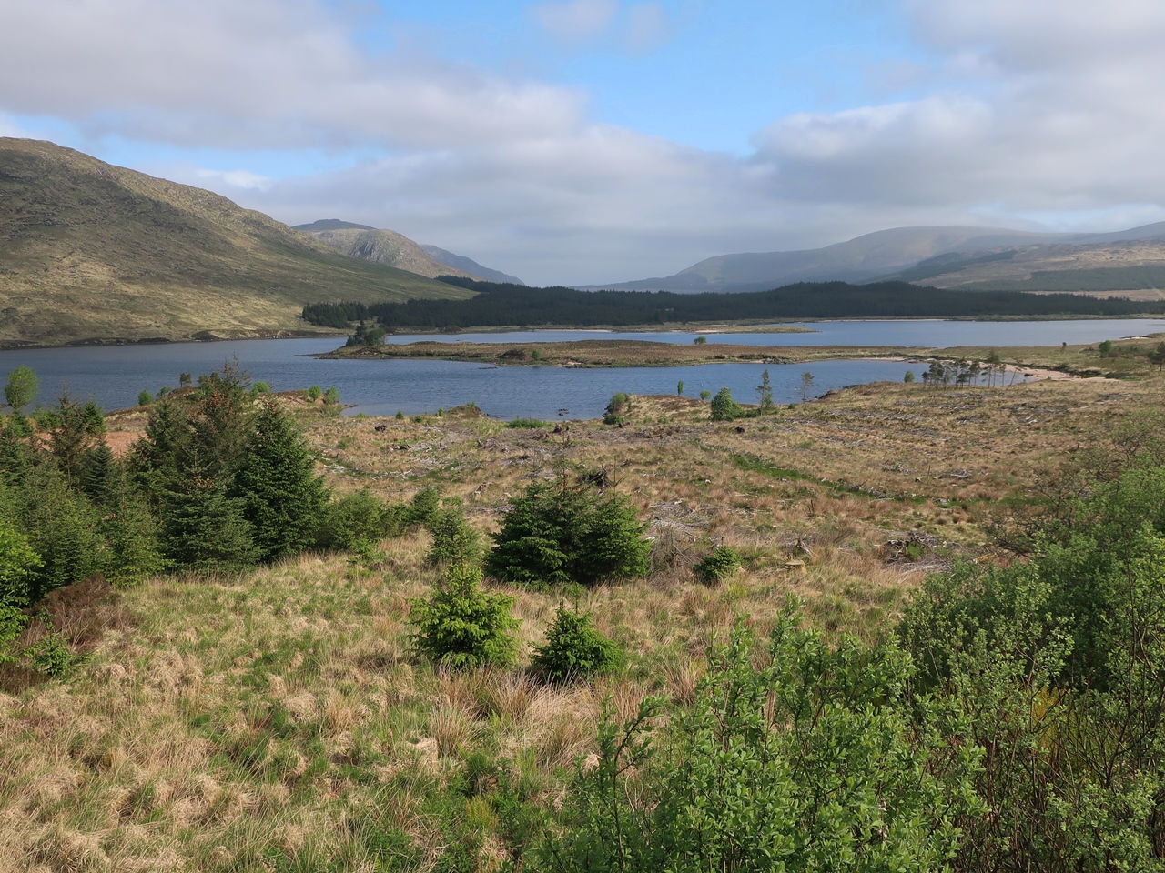
On my fourth day on the Southern Upland Way I set off from the White Laggan Bothy, where I had spent the night with a load of other walkers, and headed down the hill back onto the trail enjoying some fantastic weather that was possibly even hotter than it had ben earlier in the week. I was following a wide forestry track for several hours, which could be considered dull and uninteresting, but the views across the broad bowl of Loch Dee and the surrounding Galloway Hills looked gorgeous, rivalling anything to be found in the Highlands. After crossing the River Dee, also known as the Black Water, I no longer had the far-reaching views of Loch Dee so the walk now became less interesting as I slowly headed along the track through a conifer plantation until I reached the shores of Clatteringshaws Loch. I knew that there is a secret hoard in this area, marked by a sculptured kist, one of many hidden along the Southern Upland Way, so I started to look around, and even returned to the shore when I was unable to find the kist later one. Unfortunately the area looked like it had been trashed with litter everywhere, trampled bluebells and many burn marks, but I could not find the hoard, though I was able to get down to the shore of the loch and take some pictures.


Eventually I reluctantly decided that I had wasted too much time looking for the kist, so, disappointed, I returned to the track and followed it, now heading north. Soon, I reached a road and after a short distance along the road, back west, I turned north again uphill along a grassy path through an area of felled conifers steadily climbing towards the Rhinns of Kells. At the stream, Hog Park Strand, I came across the word “ultreia” on a trail post, which indicates that the hidden hoard was actually not far ahead of me along the trail, so all my hunting around beside Clatteringshaws Loch had been a waste of time. Keeping my eyes peeled, I slowly made my way along the trail, past the marked trail post, and carefully looked out for the kist that marks the location of the hoard. After crossing a fence I left the conifer plantation behind and followed the path onto the open hillside and soon reached another trail post with “ultreia” on the other side, which meant I had failed to find the kist. Frustrated, I took my rucksack off and retraced my steps looking everywhere for the hidden hoard, but after a long search I could not find anything. Eventually I had to give up and concede that I was not going to find the Craigenbay Hoard.


The path continued to climb across the grassy hillside, decorated with the small yellow flowers of tormentil, until I passed by some rocky outcrops and crossed over the ridge. Now I descended into the valley of the Garroch Burn where I picked up a track that took me onto the road and through the valley. The tedious road walking improved when the road entered the delightful mixed deciduous woodland of Hannaston Wood, which was a pleasure to walk through and filled with wild flowers including bluebells, stitchwort and wild garlic. Eventually I crossed the burn and climbed up Waterside Hill, but the sunshine that I had enjoyed during the morning had now been smothered by cloud. Nevertheless, this was a fun little climb up a hill that was reminiscent of the smaller fells of the Lake District and at the top was revealed the valley of the Water of Ken with the village of St John’s Town of Dalry nestled by the river. This was the first village that I had seen since the start of my walk on Monday and my first chance to restock since then. When I reached the village, across the footbridge, I made use of their facilities and, as I was coming out a chap was coming out of the adjacent town hall, and he kindly offered to let me put up my tent in the grounds, but I was keen to push on.

My original schedule would have seen me spend the night in Dalry, so his offer would have been ideal, however I had been running a couple of hours ahead of schedule since Monday so I thought it was too early to stop, despite the chap warning me that there is nowhere to camp for eight or nine miles along the trail.With hindsight I wish I had taken his offer, but I didn’t want to lose the benefit I had gained in time, so after buying some supplies I set off up the road and soon I was onto the sheep-filled fields that I had been warned about. After about three miles I reached the Earlstoun Burn which I thought was a perfect place to camp, between the stream and a conifer plantation, away from the sheep, so I stopped and put up my tent despite it still being quite early. This was a lovely spot, beside the wall, looking out across the stream and I was enjoying the sunshine that had now appeared which revealed a glorious evening. This was a very mixed day with some definite highlights, but also some negative moments. I need to dwell on the highlights and rejoice in the variety. I had a relaxing stroll along the forestry tracks, and through Garroch Glen, while Hannaston Wood was fabulous and the climb over Waterside Hill was fantastic. Now that I was on my fourth day on the trail I was starting to get used to the daily grind of walking long distances every day and I still had a lot more to come.


Unfortunately, my day didn’t end there. While reviewing my next day later in the evening, I realised that I had made an error with my provisions which meant that I didn’t have any food for my evening meal the next day. I had planned to resupply in Sanquhar, but that was twenty-four miles away, after my planned overnight stop. Because of the evening sunshine, I decided that my best option was to break camp, leaving my gorgeous camp location, and walk along the trail for an hour or two before stopping at sunset. Therefore I left the wonderful Earlstoun Burn, which had nourished me for a couple of hours, and set off again along the Southern Upland Way across wide grassy moorland, leaving the Galloway Hills far behind me, while ahead of me were the Carshairn Hills. There was little trace of a path and sometimes was rather boggy, including at one point when I lost my balance and put my foot into the bog. So it was with a wet, mud-covered leg that I continued along the faint path trying to find my way. Eventually I reached a road and followed this to the Black Water burn where there were some good places to camp, but I kept going and climbed up over Marskaig Hill and Culmark Hill, where it was difficult for me to find the path across. After reaching the access road for Culmark with the sun now getting very low in the sky, I was desperate to stop so I crossed the Carroch Lane burn and put up my tent beside Blackmark Plantation, but this was a disastrous place to stop as it was infested with midges.

Thursday 22 June 2023

Southern Upland Way: Glen Trool

Tuesday 23rd May 2023

My overnight wild camp, before this walk, was on rather tussocky ground with many branches and roots in the way, but with several subtle movements of my tent I somehow managed to find a position that was really quite comfortable. However, when I got up in the morning I was plagued by midges. I had never done any walking in the Southern Uplands before this holiday, so in my naivety I assumed that the highland midge is only found in the Highlands, but I soon found that this is not the case, although at this point in my holiday there was not a huge amount. I had difficulty finding somewhere to camp the previous night so I had continued walking for longer than I wanted to, though one advantage of where I eventually did stop was that less than a kilometre away was the Riverside Newton Stewart holiday cottages which offer free water refills from their outside tap. I took advantage of this facility a few times and I returned to Riverside again at the start of this day to refill my water bottles once more before restarting my trek on the road along the Southern Upland Way. There is rather a lot of road walking on the trail so it is best not to be using heavy walking boots, fortunately my boots were light. After passing through the hamlet of Knowe I eventually came off the road and into a lovely wood that, despite being clearly commercial, was quite open with many young trees while bluebells lined the path and the Hills of Galloway could be seen ahead which promised exciting things to come.


All too soon this great path came to a road and after a stretch along the road I branched off to climb Glenvernoch Fell while Loch Ochiltree revealed itself to my left. Gorse decorated the western slopes as I climbed with little or no path to a trig point where the view across the fell towards the Galloway Hills drew me on across the often boggy hillside where the indistinct route was marked by yellow-topped posts. The largely pathless walking across moorland continued until I finally reached the River Cree and the foot of the hills. A fun, narrow path weaved around trees and over roots as I slowly followed the river south and provided me with a delightful but strenuous walk until eventually my fun ended and I turned away from the River Cree. Soon I headed into gorgeous woodland scenery along excellent footpaths lined with stitchwort and bluebells beside the Water of Minnoch where I knew that there is a secret hoard of coins in a kist, one of thirteen on the Southern Upland Way. After a while the word “ultreia” appeared on a trail post which revealed that the kist was ahead and soon, just off the path, I found the beautifully sculptured kist. Beyond that point I had a fabulous walk through delightful woodland on a narrow path between swathes of bluebells that had me constantly clicking away with my camera as I very slowly made my way through the beautiful displays. In fact there were so many bluebells I started to get fed up with them, as if that was possible.


When I came to a bridge over the Water of Trool, I turned off the Southern Upland Way to pass even more bluebells and reach the Glentrool Visitor Centre where I took advantage of their facilities to have something to eat and refill my water bottles. Since leaving Castle Kennedy at the start of the previous day, I had hardly seen another soul so this visitor centre felt like rather a startling reintroduction to civilisation and I had still not been through any settlements larger than a couple of houses. After a rest I returned past the bluebells to the Southern Upland Way where I continued beside the Water of Trool, though I soon left all the bluebells behind. The walking was still thoroughly enjoyable as I made my way through Glen Trool until I reached a bridge at Caldons where there used to be a campsite and I have heard that it is still a good place to wild camp so I had planned to stop there. However, thanks to my extended walk the day before I was a couple of hours ahead of schedule so I had decided to keep going to the White Laggan Bothy. But my onward route along the Southern Upland Way was brought to a halt by signs that said the footpath south of Loch Trool was closed due to forestry operations so I was directed to the north of the loch.

The diversion took me past the Calgons car park and along a lovely path through gorgeous woodland with glimpses into Loch Trool and soon brought me onto a road where the walking was tedious and quite strenuous as it climbs above Glen Trool Lodge. The road undulated wearily until it finally stopped beside Bruce’s Stone, which I wouldn’t have seen if I’d been on the trail so I took advantage of the opportunity to admire the view across Loch Trool, unfortunately the patchy sunlight that I had enjoyed over lunchtime had now been smothered by cloud. Beyond the end of the road my way continued along a track that afforded me with better views over Loch Trool while the forestry operations that had forced my diversion could be seen on the other side as I slowly descended through woodland to finally rejoin the proper route of the Southern Upland Way. My map promised me that there is an alternative route up the valley on the northern slopes but there didn’t seem to be much of a path and it would be a lot easier for me to stay on the wide forestry track. Since I had not been on the official route earlier and I was feeling tired at this time in late afternoon, I decided to stick to the proper route. The track relentlessly climbed to the head of glen into what I have read is the wildest part of the Southern Upland Way, so I was keen to take in the views.


Merrick, the highest hill in Scotland, south of the central belt, lies just to the north of Glen Trool, but I had no inclination to go up to the top of any of the Hills of Galloway and I was happy to just keep to the trail at the bottom of the valley. Once I was at the top of the pass the views opened out to the shallow valley beyond and across Loch Dee in a scene that was exquisite in its untamed, wild beauty. The wide track slowly took me around the southern slopes above the loch and eventually brought me to the White Laggan Bothy. Despite overcast conditions for much of this day, especially in the afternoon, the walking into the Galloway Hills was fabulous especially past all the bluebells that I saw on this walk. I had planned on doing the Southern Upland Way in late summer which would have given me heather in bloom, but the benefit of coming in May far outweighs that and I am glad that I did as I love bluebells and Glen Trool is one of the best places in the country to see them.

Thursday 15 June 2023

Southern Upland Way: Glenwhan Moor

Monday 22nd May 2023

After two nights in Stranraer at the Aird Donald Caravan Park, I broke camp and caught a bus to Castle Kennedy which was where I had reached on the Southern Upland Way the day before. Now I was beginning a long stretch on the trail with little sign of habitation and no shops for fifty miles, so with my rucksack heavily laden I set off from Castle Kennedy along the lane that leads to the gardens. I didn’t have time to look around them but I still had a pleasurable walk along the drive which was lined with bluebells, wild garlic and many other delightful woodland flowers while rhododendron decorated the scene beyond and made me reluctant to leave. All too soon I emerged onto a minor road and after a short time I took a track that slowly climbed and afforded me with views over gorse bushes back towards the Rhins of Galloway that I had crossed the day before. It was a lovely sunny day with a brisk wind that I felt fortunate to be enjoying after a cold, wet spring that had severely affected my holiday at Easter. After another short spell along a road I turned off onto an access track that led me into Glenwhan Moor conifer plantation, but the Southern Upland Way fortunately just skirts the edge between the outer wall and the conifers, so I was able to have an enjoyable walk, though my mind was on something else. Hidden along the whole length of the trail are thirteen sculptured kists and on my first day I had found the minted coin hidden inside the first kist on Broad Moor, and I knew that the second kist was on Glenwhan Moor so I kept my eyes peeled for anything unnatural that might possibly contain hidden treasure.


Even though I didn’t find anything for a long time I still had a lovely walk on a dry path in the sunshine with the hills of Galloway in the distance that promised future delights while colourful wild flowers, notably bugle, lay at my feet. If more of the Southern Upland Way was like this path then I would be very happy, but I was sure it would not. Eventually I came across the kist, marked as usual beforehand by the word “ultreia” on the preceding trail post, and it was hard to miss as it was clearly labelled beside a clootie tree where strips of cloth or rag are tied for some Celtic custom. I ignored all this and picked out a coin before continuing along the path into the conifer plantation, soon descending under dark conifers with wood sorrel decorating the floor to cross the Craig Burn. Beyond the burn the deciduous woodland floor was covered in bluebells and stitchworts that followed me beside the path through Airyolland Wood until I crossed the railway line and descended to the Water of Luce, my first big river on the trail. After a climb to a road I took to an arrow straight track that led me across Kilhern Moor while dozens of wind turbines could be seen across the hills ahead of me.


At one point I came across an adder that was basking in the sunshine on the path, so I carefully went around it before continuing along the trail. At Kilhern, the moorland scenery was replaced by farmland and I turned into the cold wind to follow a track to a road where I turned right up the valley beside the Cross Water of Luce slowly climbing towards the wind turbines. Eventually I surpassed the previous highest point on the trail so far, on Broad Moor, and continued to climb while my rucksack began to feel heavy on my back despite having felt surprisingly light when I first put it on my back at the beginning of the day as the monotonous climb and sunshine drained me of energy. Soon after the gradient finally eased I entered a vast conifer plantation that was littered with tall wind turbines and after an initial boggy stretch the path improved and I reached a forestry track that provided me with easy walking to take me to the Beehive Bothy at Laggangarn. This would have an awesome place to spend the night, but it was only three o’clock and I felt it was far too early to stop. If the weather was bad or I was not feeling great, then I would have stopped at this time, but neither of those were the case so I pushed on past some standing stones and down to the Tarf Water.

From there I started to climb again along a path that was enlivened by wood sorrel, bluebells, bugle and buttercups, which encouraged me to keep going until I reached a cairn at Craig-dhu where the hills of Galloway, including the highest point, Merrick, could be seen above the trees. Even though I would not be climbing those hills on this holiday it was still great to see them and they almost made me ignore the extensive conifer plantation and wind farm that lay in the way. More climbing through the conifers and past wind turbines brought me to my new highest point on the trail so far at the top of Craigaire Fell, 320 metres above sea level, where a trig point marked the summit and I had extensive views in all directions. The path beyond led me steeply down the hill onto a forestry track and alongside the edge of a moor that tops on Craigmoddie Fell where I had considered camping but it was still rather early and I didn’t want to stop so I kept going onto a road that provided me with frustratingly no opportunities to camp. By five o’clock I finally wanted to stop but there was nowhere to camp. Eventually, with the time approaching six o’clock, I reached Waterside holiday cottage where a sign indicated that I could refill my water bottle, which I eagerly took advantage of, and, now desperate to stop, I soon found somewhere to put up my tent, beside some felled conifers, despite the ground being rather tussoky.

This was my first proper day on the Southern Upland Way, now carrying all my gear, and I saw a lot of variation. There were some great sections of the trail where I saw some fabulous wild flowers like at Castle Kennedy Gardens and along the excellent footpath beside Glenwhan Moor or through the bluebells in Airyolland Wood, but other sections saw prolonged road walking which was not fun. I had loved the idea of not knowing where I was going to camp on this trail and having the freedom to just put up my tent wherever I reached at the end of the day, but in practice it is not as easy as that, although in the end the proximity of the outside watertap at Waterside was a great benefit to where I eventually stopped.

Thursday 8 June 2023

Southern Upland Way: Broad Moor

Sunday 21st May 2023

After my original plans for this day fell through and I had to hastily find a replacement, I considered resuming my walk along the Dales High Way which I had abandoned at Easter, but in the end I decided to go with a walk that I had planned to do later in the year along the Southern Upland Way. This is a coast to coast long distance trail than runs from the south west of Scotland across the hills between Glasgow and the English border all the way to the North Sea and covers an area that I had never done any walking in before. I have been coming to Scotland for a walking holiday every year for almost twenty years but I have previously always gone straight past the Southern Uplands and into the Highlands. Now, when I my train dropped me off in Glasgow, instead of catching a train north towards Fort William or Inverness, I caught one that was heading south and eventually I got off the train in Stranraer. This used to be an important ferry terminal, but now the ferries to Ireland leave from Cairnryan further up the coast which has left Stranraer as a quiet backwater. The railway station is still beside the old ferry terminal at the end of the pier, but there is nothing else there now.

After a night spent at the Aird Donald Caravan Park, I caught a bus to Portpatrick, on the west coast, where the Southern Upland Way starts. Rather than immediately setting off along the trail, I had a look around, walking around to the old lighthouse before circling around the harbour and past the modern lifeboat station. My map indicated that the Southern Upland Way starts from the northern tip of the harbour but an information board nearby revealed that the trail starts from the end of the pier. So, I made my way past the harbour buildings and onto the rocks at the end of the pier which were liberally decorated with sea pinks and bird’s foot trefoil. This was a wonderful place to explore and I was glad that the board had directed me in that direction. Nearby was a signpost that proudly directed the Southern Upland Way back down the pier, so I set off along the trail and up beside the coast. Wildflowers proliferated including gorse beside a golf club while at Port Mora I found red campion and bluebells which enlivened the scenery despite low cloud.


The exit from Port Kate was hidden behind a large rock and only became clear on closer examination involving a steep climb back out of the cove and onto the grassland of Ouchtriemakain Moor where a large lighthouse ahead of me marked the point where I would start to turn inland. I had mixed feelings about this as I was enjoying the stunning coastline but you can’t cross Scotland to the east coast by walking north up the coast. At Killantringan Lighthouse I joined a road and followed it up the hill, steadily climbing away from the coast and into potentially dreary countryside, mostly farmland, however, I just used the opportunity to relax and begin to unwind from the stresses of work as there is no better place to recover than on a good walk and I was looking forward to all that was ahead of me on the Southern Upland Way. Eventually I came off the road and found a sign that announces the presence of hidden treasures along the Southern Upland Way in sculptured kists. The word “ultreia” on a marker post just before I entered Broad Moor revealed that soon I would find one of these kists so as I made my way along the path I kept my eyes peeled for the hoard. Rather than relaxing I was looking for the kist and eventually I did find it and the specially minted coins inside.


I was happy to find my first kist and was accepting of the fact that I would probably not be able to find all thirteen along the trail. After pocketing just one coin I continued along the path through the moor where, although the heather was not at its best, the bilberry provided some welcome colour with its fresh growth. At the far end of the moor, beside Knockquhassen Reservoir, I joined another road and followed it for a prolonged spell, over a low hill and around Stranraer with views towards Loch Ryan beyond. Despite the tedium of the road surface, my walk was enlivened by many wildflowers that decorated the verge including bluebells, stitchwort and red campion. The road walking eventually brought me to a wood that was beautifully decorated with wild garlic and swathes of bluebells. While taking in the gorgeous displays I started to have a sneaking suspicion that I had strayed off the Southern Upland Way and this was confirmed when the outskirts of Stranraer came into view so I hastily I retraced my steps past the bluebells that I shouldn’t have seen and found the junction that I had missed where I now turned to follow the much narrower path through more woodland and past more bluebells until eventually I reached the village of Castle Kennedy.


This marks the end of the first stage of the Southern Upland Way, but I couldn’t leave without a brief wander through Castle Kennedy Gardens, although I didn’t go far and after gazing across the waters of White Loch I took a path through Douglas Wood and Macgill Wood until I could go no further and I emerged onto the main road. This was a good introduction to the Southern Upland Way that eased me gently into the trail, a relaxing first stage with a lot of road walking and no hills. The highlights were the fabulous coastline and the many wild flowers, especially bluebells, so it was a pity I didn’t have better weather. The sun finally began to break through the cloud towards the end of the walk so I able to spend a pleasant evening in Stranraer after an easy day before the really strenuous walking would begin the next day.