Thursday 27 July 2023

Southern Upland Way: The Ettrick Hills

Sunday 28th May 2023

I had a lovely night in the town of Moffat, staying at the youth hostel, that left me feeling like I must return again to explore the area where there seems to be many good walks. I wanted to have a rest at the start of this day and to delay my walk, so I wandered around the town for a couple of hours before buying some supplies and slowly heading out of Moffat back to the Southern Upland Way. Instead of retracing my steps of the day before to the exact spot where I had left the trail, I took the Old Carlisle Road out of Moffat and rejoined the Southern Upland Way just before Drumcrieff Bridge. I joined the trail just as it started to come good again on entering Drumcrieff Wood, even though at first there didn’t seem to be any woodland flowers and all the trees were young, however after eating my lunch perched on a log I veered off the path and discovered a blanket of wood sorrel covering the woodland floor. Then I came across some bluebells and even more after returning to the trail, which also veered towards the Moffat Water but almost immediately left the wood to pass beside a large field with tall grass. After crossing a road, wide tracks took me through farmland gradually climbing beside the Cornal Burn and into a conifer plantation where I had a choice to make. A high route would take me very steeply up to Croft Head while a low route would take me along forest roads. The high route would be very exhausting in the hot weather, while the low route would be much cooler as I would be sheltered by the conifers. In the end, my choice was made by tree-felling operations on the lower route, so I took the path that crosses the Cornal Burn and heads up the valley past an open area of young trees.


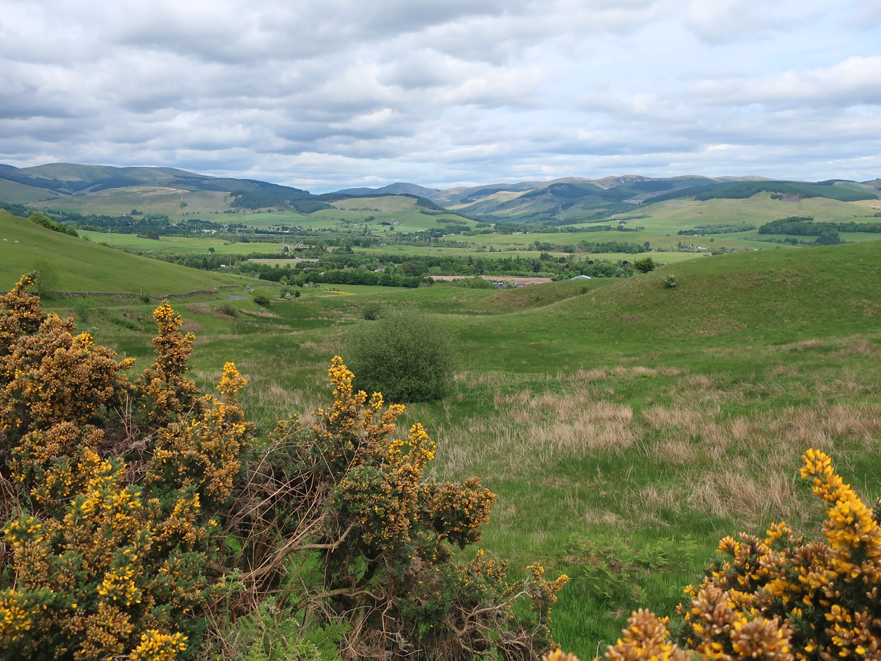
My climb was briefly relieved by a forestry track, but I soon came across a trail post that directed me onto a grassy path that led me steeply up the hillside through thick conifers, zigzagging up the hillside on a relentless climb, slowly, step by step against the sheer gradient. Eventually I emerged out of the trees at a blessed forestry track where I could stop and gaze at the stunning views back across Annandale and the town of Moffat, and catch my breath. A wander along the track took me to a sharp bend around the head of Littlehope Burn where a path heads straight up the hill and out of the trees onto the open hilltop of Gateshaw Rig where the views were now amazing all around me, but most particularly ahead of me towards the steep sides of Craigmichen Scar. I was mesmerized as I made my way along the narrowing ridge, eventually reaching the top of Croft Head, a Graham-classed hill, but with nothing to mark the summit except a junction of fences. To my left were the high Moffat Hills including Hart Fell and White Coomb that were looking really tempting in the good weather, but are sadly not on the Southern Upland Way so I would have to wait for another day. After passing over Croft Head the path began to descend along a fabulous ridge known as Cat’s Shoulder that led me to a precipitous descent down an awesome, zigzagging path. It was a pleasure to walk along such a well-engineered footpath that is so well established as to be perfectly integrated with the landscape.


At the bottom I joined the path that comes up from the conifer plantation, the original route, but now just regarded as a wet weather low route, and together we headed beside the Selcoth Burn below the towering crags of Craigmichen Scar. The path headed slowly up the valley through tremendous scenery until eventually, just before crossing the Selcoth Burn, I came across a trail post with the word, “ultreia” marked on it, which signifies that ahead of me I would find a hoard of hidden treasure and soon after crossing the burn I found the sculptured kist that marks the location of the hoard. Inside I found some coins, so after pocketing one I headed off along the path and up to Ettrick Head. I was in awe of the scenery on this walk, which was comparable to what you would find in the Lake District and yet I had not seen a single person since leaving Moffat. This was a Bank Holiday weekend and the weather was fantastic in an area that is great for walking, but everyone drives past on their way to the Highlands or the Lake District. I am just as guilty of that myself, but never again. I am not going to be able to drive past these hills again as they have won me over on this walk. The whole area around Moffat, including the Lowther Hills to the west, is great hillwalking country.


At a fence I came across a signpost that proudly proclaimed: “Welcome to The Scottish Borders”. For almost the entirety of my walk along the Southern Upland Way I have been passing through the county of Dumfries and Galloway. On my descent from Lowther Hill two days earlier I had passed into the gathering waters of the River Clyde and the county of South Lanarkshire, but when I entered Greskine Forest the day before this walk I re-entered Dumfries and Galloway. While in that county all the waters and rivers had flowed south and ultimately into the Solway Firth. While in South Lanarkshire the waters flowed north into the River Clyde, but ultimately still ended up in the sea off the west coast of Scotland. From Ettrick Head all that would change as the waters and rivers that I now walked beside flowed east into the River Tweed and the North Sea, which was also where I was headed. This was a monumental moment, much more significant than the halfway point the previous day. Now I was now in the Scottish Borders where I would be for the rest of the walk and I would be walking with the waters rather than across them. Unfortunately, almost immediately after crossing the national watershed, I entered a conifer plantation where no views were to be had.

A forestry track soon appeared and took me through the wood to Over Phawhope Bothy, which is the last bothy on the Southern Upland Way so I was keen to stay there overnight. There are five bothies beside the trail and previously the only one I had stayed at was White Laggan. I had merely visited the Beehive Bothy, the Chalk Memorial Bothy and Brattleburn, having my lunch at the last two, so I was keen to stay at this bothy. My delayed start to the walk meant I was coming down into the valley late afternoon, just in time to stay there. I was over-awed by the scenery on this walk and generally around Moffat, which is cruelly ignored by people, including myself, but this walk sealed my fate as I now swore to return and explore the area. I had a fabulous walk along the ridge over Croft Head, helped by gorgeous weather, but the scenery speaks for itself. I was smitten by the Southern Uplands.

Thursday 20 July 2023

Southern Upland Way: past the halfway mark

Saturday 27th May 2023

Despite a lovely evening beside the Potrail Water near the Dalveen Pass, I did not get a good night’s sleep before this walk and therefore I was very tired as I set off along the Southern Upland Way for my seventh day on the trail. During the previous couple of days I had climbed over some of the highest hills on the trail including the top of Lowther Hill, which at 725 metres is the highest point on the Southern Upland Way and at the end of the day I had camped at the foot of the hill within sight of the golf ball shaped radar station that is at the summit. Since my second day on the trail I had been ahead of schedule but I was booked to stay in Moffat so I would have to give it all up, which I was happy to do as I felt like I needed an easier walk after the previous couple of days. Initially I headed into Watermeetings Forest, which, on paper, is a conifer plantation, but in fact I found a lot of deciduous trees had been planted alongside the trail on an excellent path that was a pleasure to walk upon. The track soon left the wood and crossed the northern slopes of Comb Law before reaching a post that proclaimed that I had reached the half way point on the Southern Upland Way, 107 miles from Portpatrick and just 107 miles to Cockburnspath. Since it had taken me just over six days to reach this point, I figured I would reach the end of the trail around midday on Friday, which was exactly on schedule.


The southern hills of the grassy Lowthers dominated my view south and were pleasing to gaze upon but the views north were ruined by the vast Clyde Wind Farm. At a junction I came across a sign that diverted me away from the dam for Daer Reservoir, due to construction works, and took me down the road, across the Daer Water and up towards the waterworks buildings. On the way I passed an old Southern Upland Way signpost which reveals that the diversion was actually taking me along the original route of the trail. After crossing Hapturnell Burn, at the gates to the waterworks, a signpost directed me up the hill, around the buildings and slowly up the grassy slopes of Sweetshaw Brae. Behind me were stunning views across the Daer Valley and towards the Lowther Hills where the golf ball was still clearly visible, and I was prompted to stop many times to take in the view during my ascent. Eventually I rejoined the current route of the Southern Upland Way, beside a fence, and followed that up the hill and along the wide grassy ridge. The wind picked up as I cruelly climbed again to reach the top of Hods Hill where the fence turned to the south and the views east were revealed across Annandale and towards the Moffat Hills which include some of the highest hills in the Southern Uplands. However, to the south the view extended all the way down Annandale to the Solway Firth and on the horizon was a line of high hills that I realised, with excitement, were the fells of the Lake District.


My tantalising glimpse of that most beautiful of landscapes was soon lost as I descended alongside a conifer plantation and after passing over Beld Knowe I turned into Greskine Forest to slowly descend through a delightful landscape decorated with the yellow flowers of tormentil and broom. Large areas of the plantation have been felled, which gave my descent an airy feel and afforded me with good views down the valley and across to the high Moffat Hills. Soon after crossing the Cloffin Burn I turned off to head along an astonishingly muddy path towards Brattleburn Bothy, which was a disappointing place, but I stopped there to have my lunch. After returning to the Southern Upland Way, I found that this path was also boggy and frustratingly climbed over Craig Hill before crossing into the valley of the Garpol Water. I was now in thicker woodland that was less interesting to walk through but at least provided me with some shade from the sun. I slowly made my way through this dull terrain past tall trees that were blocking all my views so I was relieved when I eventually reached the Earshaig Lochans and the Crooked Road. Turning right, I joined the long distance trails of, first, the Romans and Reivers Route, and then the Annandale Way as the road weaved through the landscape and down into the valley of the River Annan with views across to the Moffat Hills.

Eventually I reached the village of Beattock where this stage of the Southern Upland Way ends having come twenty miles from Wanlockhead, where I had originally planned to start, even though I still had several miles to go until I reached my overnight accommodation in Moffat. With hindsight, it is a good thing that I was ahead of schedule as this was not turning out to be a short day even with starting after the Lowther Hills. It is amazing to think how strenuous this day would have been if I’d walked all the way from Wanlockhead over the Lowther Hills, the highest point on the whole trail, and then around the hills that surround Daer Reservoir.  Fortunately I had been ahead of schedule so it was only mid-afternoon when I reached Beattock and after passing below the motorway I turned off the Southern Upland Way and followed the Annandale Way into the town of Moffat. There was little of interest on this walk, but most significantly I passed the halfway point so it was all downhill from here on!

Thursday 13 July 2023

Southern Upland Way: The Lowther Hills

Friday 26th May 2023

When I reached the village of Sanquhar the previous day I asked at the Tolbooth Museum about possible camping locations and I was directed to Newark Farm where the proprietor, the lovely Francis Barbour, offered me bed and breakfast instead and the temptation of a shower and a comfortable bed proved impossible to resist. The previous night I had camped surrounded by millions of midges, which had left me traumatised and covered in bites, so I was grateful for the chance to recover and, after a lovely night and an even lovelier breakfast, I set off from Sanquhar. The weather was again stunning with hardly a cloud in the sky and I reflected about how extraordinarily lucky I have been with the weather in Scotland in recent years, just not at Easter in the Yorkshire Dales. A steady climb took me out of Sanquhar up grassy hills and between Conrig Hill and Willowgrain Hill before descending to the delightful Cogshead, which is a quiet, secluded valley. Hidden there on the trail is a hoard of treasure revealed by the word “ultreia” on the trail post coming down into the valley, but I could not find any sign of the kist that contains the specially minted coins for the Southern Upland Way that should be at Cogshead. When I reached the word “ultreia” on the other side of the valley I dumped my bag and retraced my steps to hunt for the treasure, but eventually I had to give up. This was the second kist on the Southern Upland Way that I had not been able to find, but I was happy with the ones that I had found so far and at least it won’t add to the weight of my rucksack!

Soon, I was climbing out of the valley again and over the grassy hills north of Glengaber Hill before descending on an excellent well-graded path that took me into the valley of Wanlock Water with the village of Wanlockhead, the highest in Scotland, clearly in view. At the bottom I slowly made my way up the valley passing the relics of lead mining that used to be carried out in this area. Information boards described what used to happen in the valley and I stopped to read them all, fascinated by the industry, and the labour intensive process that was required to extract the lead. The track became a road and after a while the Southern Upland Way branched off onto the route of an old tramway that took me up into Wanlockhead. This is a fascinating area, which would merit spending some time there. The official schedule for the trail stops at Wanlockhead after walking just eight miles specifically to give you time to explore, but I wanted to keep going, though a return visit would be a very good idea. I passed through the village and was struck by its Alpine feel due to being the highest village in Scotland, which I was seeing at its best in fabulous weather. I’m sure it doesn’t look so appealing when the mist in down. I continued to climb up the hill, out of the village and towards the golf ball, a radar station, at the top of Lowther Hill.


The views got better and better in all directions, across the Lowther Hills, as I climbed. My attention soon moved away from the views over Wanlockhead to those north towards Shortcleuch Reservoir, east towards the top of Lowther Hill and south down the Mennock Pass. I slowly continued the climb, crossing the access road for the radar station several times, while the view prompted me to stop many times to take pictures until eventually I turned to pass just the south of the summit of Lowther Hill and cross the slopes past a metal box-shelter, known as the lunchbox. This is the highest point on the Southern Upland Way, easily beating the previous highest point so far, on Benbrack, by about a hundred and fifty metres. There were extensive views south into wide, tree-filled Nithdale while east the Lowther Hills continued over a complex range of grassy hills. The views north-east were less appealing across the vast Clyde Wind Farm where hardly any of the turbines were turning. When the weather is as good as this it is fabulous to be at the top of a hill and to take in the awesome views. The path took me slowly down the hill before climbing up to the top of Cold Moss and along the ridge to descend to another col where a final climb took me up Laght Hill.


Half way up I came across a trail post with the word “ultreia” hidden at the bottom, which I thought was rather sneaky as the word is usually at the top of the post, just underneath the trail symbol, so I kept my eyes peeled, but all I could see was the broken wall beside the path. Eventually I reached the top of the hill and there I found the kist with its hoard of coins, however with hindsight I have realised that the coin I took should have been at Cogshead, so maybe both hoards were there? I’ll have to return sometime. The trail continued over the hill and steeply down to reach a road, which was fast, but quiet and eventually I left the road to cross fields and reach the Potrail Water. After crossing a bridge I stopped and threw up my tent beside the burn in a lovely spot not far from the edge of a conifer plantation. I had been feeling as if my wild camping spots so far on this holiday had not been very enjoyable, especially the night before Sanquhar when I was besieged by midges, but this site was recommended by the ramblingman.org.uk website and in this weather it was divine. And there were no midges! This was an amazing walk as it was great to up high on the Lowther Hills in sensational weather and Wanlockhead was interesting so it would merit a return visit and that was the first time I’d thought that on this trail.

Thursday 6 July 2023

Southern Upland Way: The Scaur Hills

Thursday 25th May 2023

My overnight camp before this walk was a big mistake. I had miscalculated how much food I would need so I had to get to the village of Sanquhar before the end of the day or I would not have anything to eat for dinner. To that end I had set off again along the trail during the evening and eventually stopped beside Blackmark Plantation as the sun was setting, but I was besieged by midges that followed me into the tent and again the following morning as I tried to have my breakfast and get ready. After this horrible end to the day and an even worse start to the next day I consequently had many midge bites around my face so I was more than happy to get away from the savage beasties. Since I had never done any walking in the Southern Uplands before, in my naivety I thought midges were only found in the Highlands, but now I discovered that there are plenty of midges there and they come out earlier than further north. Cloudless skies and no wind was encouraging the midges so I broke camp as quickly as possible and set off again along the Southern Upland Way, crossing the Stroanfreggan Burn and taking a path that climbed through boggy, grassy moorland as I gradually approached another conifer plantation. Thanks to the lack of wind the turbines of Wether Hill Wind Farm were barely turning and I was soon getting hot from the climb until eventually I crossed the fence into the plantation and continued the climb through the trees into the Scaur Hills.


The trail followed the top of a ridge that escapes the conifers and initially climbs to the top of Manquhill Hill, which at 421 metres was easily the highest point on the Southern Upland Way so far. The western slopes of Manquhill Hill were decorated with cotton grass which provided me with a great foreground to the views across to Cairnsmore of Carsphairn, one of the highest peaks in Scotland, south of Glasgow, while behind me were extensive views to the Galloway Hills, but I was more concerned about the view before me towards Benbrack, which was a steep hill that soon I was going to have to climb. The ridge descended for a bit before starting the ascent up grassy slopes where I stopped frequently to admire the views behind which were dominated by Cairnsmore while the Galloway Hills became rather hazy. Eventually I reached the summit where there is a trig point and a huge sculpture of an arch made of stone. At 580 metres above sea level, Benbrack is one of the highest hills on the Southern Upland Way and I was thankful that I was there with clear skies overhead and enjoyed the feeling of being up high as I followed a fence along the ridge passing over Mid Hill and up Cairn Hill to reach Black Hill where I turned north. The trail now began to descend and entered a conifer plantation, though large areas were felled.


After passing Allan’s Cairn the path plunged into a dark covering of conifers where some fallen trees had to be negotiated until eventually I emerged on the other side where the descent steepened taking me all the way down to the Chalk Memorial Bothy near Polskeoch. This had originally been my planned overnight stop, but since my second day on the trail I had been a couple of hours ahead of schedule and following my mad dash the previous evening it was now lunchtime so instead of stopping overnight at the bothy I stopped there for lunch. I wish I had stayed there as it is just a single, large room, which would have made for a great atmosphere, though it is not far from a road so the people who stay there may not be serious walkers. After a rest and refilling my water bottles I set off along the track that soon became a road and into the valley of the Scaur Water, which lends its name to the hills in this area. At first I thought the valley was very bleak with bare, grassy slopes, typically British, but once I finally came off the road and began to climb the side of the hill I was able to see the whole valley and appreciate its charms. Beautifully decorated trail posts with encouraging messages down one side directed me across the side of the hill where I had good views down the valley which steepens pleasingly, especially around Glenwhargen Crag, which looks stunning.


Meanwhile, below Cloud Hill, my attention was arrested back to the path because I had just come across the word “ultreia” on a post which indicates that a hoard of treasure is ahead concealed in a kist, one of thirteen on the Southern Upland Way. So I kept my eyes out and soon I saw something that didn’t look natural and when I investigated I found something marked with the thistle trail sign and inside the kist were specially minted coins. After pocketing one I returned to the footpath and soon entered an area of recently planted conifers before finally climbing up to the top of the ridge and up to the northern slopes of Whing Head. Now I had a long, gradual descent with the broad valley of Nithdale and the village of Sanquhar in the distance ahead of me. I was in no hurry and enjoyed the descent that eventually brought me into Sanquhar where I briefly walked beside the River Nith before passing Sanquhar Castle and along Castle Street into the village. This was a very hilly day on the Southern Upland Way as I crossed the Scaur Hills which includes the highest point on the trail so far. With hindsight I shouldn’t have done my mad dash the previous evening as I could have just gotten up early and so avoided my nightmare overnight camp. Though my day didn’t start well, once I got going I had clear blue skies which made for great views and so long as I kept on drinking I was able to have an enjoyable walk.