Thursday 19 May 2022

The Great Trossachs Path

Wednesday 20th and Saturday 23rd April 2022

After a very cold night that put my sleeping bag to the test, I was greeted by sunshine and it soon warmed up, so I finally broke camp and left Arrochar to walk along the road to Tarbet where I caught the ferry across Loch Lomond. I got off the ferry on the eastern bank beside the Inversnaid Hotel where the West Highland Way passes heading north while another long distance trail, the Great Trossachs Path, starts its thirty mile trek through the Trossachs ending in Callander. I had planned to walk the Great Trossachs Path at Easter 2020 and was all booked and ready to go when Covid put a stop to all my plans, so now two years later, I was finally going to do the trail. Initially I had to climb steeply through lovely woods on a path that was badly eroded in one place, though with my rapidly gained height above Loch Lomond, I had great views across to the Arrochar Alps including Ben Vorlich that I had climbed a few days earlier. Once the path entered a conifer plantation it became very muddy and I feared that this poor start to the condition of the trail would be the norm for the whole length, but far from it. Soon I reached the car park for Craigrostan Woods where I dropped down to Arklet Water and walked along a road past the Inversnaid Bunkhouse to the Garrison of Inversnaid.


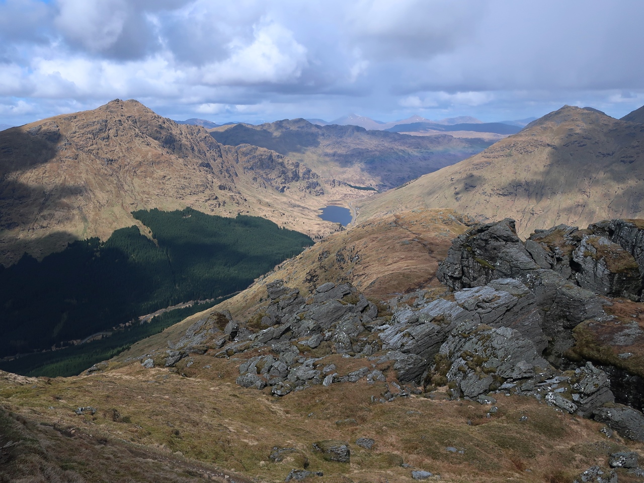
This was the site of a barracks in the eighteenth century, but is now just a farm and there I discovered a wonderful, well-made footpath took me through Glen Arklet and the RSPB nature reserve of Inversnaid. However, I was carrying a very heavy rucksack, which was already proving to be making the walk difficult for me and I was reminded of my first day on the Fife Coastal Path last year when I struggled so much and eventually stopped after four hours and just eight miles, and I was now using the same rucksack. This time I didn’t have an option to give up as there were no buses that would take me to my campsite and let me resume the walk the next day with a lighter load. I had to keep going. Perhaps I was better prepared now and the rucksack was not as heavy, so I was able to keep going, but this was still a difficult walk and a great trial of my determination and stamina. Every ascent on the undulating path was an agony. Eventually, after passing to the north of Loch Arklet, I returned to the road and reached the shores of the fabled Loch Katrine where I stopped to have my lunch and enjoy the views across the loch to Ben A’an before setting off along the private road around the reservoir.


Unfortunately this road also undulated and each climb was absolute agony as I struggled to carry my heavy rucksack along the many miles of the private road. On this western section of the road, many of the bridges showed signs of being recently upgraded to cope with large amounts of water such as from the heavy storms of recent years. Signs warned that the road would be closed if bad weather was forecast, but I had no such problem as the sun was shining with the weather continuing to improve throughout the week. Eventually I reached the western tip of Loch Katrine where rugged mountains lined tranquil Glen Gyle ahead of me before turning east I headed along the north shore. This bank had more woods and the road was decorated with celandines and primroses, which was a welcome sight while overhead clouds obscured the sun that had shone throughout the morning. Despite some dark clouds, fortunately it never rained as I continued to slowly make my way along the road including up some particularly prolonged climbs that were a trial to ascend, so I was glad when much later I realised a path branched off down to the shore while the road ascended once again.


The Great Trossachs Path would be so much better if the whole of the route around Loch Katrine was on such paths as this was a delightful walk beside the shore of the reservoir, but all too soon I came back onto the road and dragged myself into the Trossachs and to the pier where the famous Sir Walter Scott steamship was anchored. The scenery around the Trossachs was delightfully wild and I was glad to finally be able to see why this area is so highly regarded, but as I approached the pier the commercial aspects began to intrude and marred the experience for me. However, I wasn’t seeing the area at its potential worst as having already walked seventeen and a half miles along the Great Trossachs Path after a late start, it was now six o’clock in the evening and the place was deserted. The trail continued along a public road before turning right onto another private road through delightful woodland, but soon I crossed Achray Water and entered another conifer plantation. After three days of walking in the Argyll Forest Park I was fed up with lifeless conifers and now I was in the Queen Elizabeth Forest Park amongst more conifers.

The path turned several times and climbed the hill, which at this late hour after many miles along the trail I was not in the mood to do, so I was relieved to come across a sign that directed me off the forestry track onto a good path that crossed a road onto a wide forestry road and led me down to the shore of Loch Achray where the national park has a campsite. This was a stunning location and I spent three nights there enjoying the Trossachs before resuming the Great Trossachs Path along the forestry road beside Loch Achray. After eventually crossing Black Water I incongruously passed a London double-decker bus that was parked next to the Byre Inn, before walking beside the road through the village of Brig o’ Turk. A good, recently-built footpath took me to Lendrick Hill car park where an excellent visitor centre enabled me to use their facilities and fill up my water bottle before tackling a steep, torturous climb on a good path through woodland. At the top I was rewarded with stunning views back towards Ben Venue while a wonderful terrace path took me across the hillside above Loch Venachar while I enjoyed the fabulous views in the sunshine, though now a cold, easterly wind was blowing.


With the small town of Callander in sight, I was eager to finish the trail, especially as I had a bus to catch and start my journey home, but first I had follow the path around the old fort of Dunmore through an area thick with gorse. Eventually I reached the road where I joined the course of an old railway that passed between meadows filled with delightful wildflowers, but I was in too much of a hurry to catch my bus so I couldn’t stop and enjoy them as I would have loved to do. The Great Trossachs Path has a lot of variation from the short climb up from Loch Lomond that was the roughest of the entire trail, to the prolonged walk along the road around Loch Katrine and the terrace path above Loch Venachar that leads into Callander. I was frustrated with the large amount of tarmac on the trail especially around Loch Katrine, but generally the paths are very good, partly because nearly all of it can be cycled which demands a high standard from the trail. In 2020 I had planned to do the trail at the beginning of my holiday starting from Callander, so going in the opposite direction and I think that may be the better way as the best views are then ahead of you and the worst of the footpaths are on the final descent down to Loch Lomond. Although short for a long distance trail at only thirty miles, it is an excellent way to explore the delights of the Trossachs, especially if, like me, you have never been there before.

Thursday 12 May 2022

Ben Donich

Tuesday 19th April 2022

After a cold night, I awoke to the welcome sight of sunshine and eagerly headed back along the path that runs below the Cobbler, but this time I branched right away from the route of the Loch Lomond and Cowal Way onto a forestry track that climbs past dreary conifers before descending into Glen Croe. I had hoped to find the old military road that heads up the valley, but the start must be too far away and I was beside a busy main road with cars rushing closely past me that didn’t make me feel safe. Eventually I retraced my steps to the point where I had come onto the A83 road and tried to force my way through heather and young conifers on the far side of the valley, which this was not easy, but eventually I managed to get through and once I was amongst more mature conifers an easier passage brought me to the forestry road that I had passed down the day before. Rather than turn right, I decided to turn left and walk a mile down to the Ardgartan car park where I was able to use their facilities and reflected that with hindsight I should have copied my route of the day before to the car park. The sunshine that I had woken to proven to be short-lived as clouds now covered most of the sky, and would stay for much of the day. Heading back up Glen Croe I was on tedious forestry roads that have no appeal as they are too wide and flat while the trees prevented me from having a view.


Slowly I climbed the valley with no respite in the tedium, until at one point there was a break in the screen of trees that revealed views across and down the valley. I felt I had to take advantage of this opportunity to take in the view so I stopped to have my lunch. Setting off once again I continued to climb up to the infamous pass known as Rest and be Thankful, but more properly Bealach an Easain Duibh. My track didn’t go to the pass but veers west into the start of Gleann Mòr and soon after a path appeared on the left that climbs through conifers and is signposted for Ben Donich. I had planned on climbing this mountain in 2017 until bad weather forced me to stay in Inveraray, so I was glad to have this opportunity. I was also inspired by Abbie Barnes of Spend More Time In The Wild who live-streamed from the summit last year, so I was also following in her footsteps. The path zigzags past the conifers to a fence where the trees are left behind and a boggy path took me up the broad, northern ridge of the mountain. At first this was an exhausting climb, but slowly I dragged myself up undeterred by the grey clouds above the mountain that sprinkled light rain on me.


When the terrain eased I was better able to appreciate my surroundings while the sun also came out to highlight the mountains around me. Beyond this brief pause in the climb was a craggy section which is always a delight as it’s nice to have rock underfoot and at one point a bit of down-scrambling was required, which though very easy, was very satisfying. This now felt like a proper mountain and I felt energised to keep going until I reached the broad summit plateau, which I traversed to the trig point. At the moment when I reached the top the rain that had never really stopped throughout the ascent finally cleared finally affording me with sunshine and tremendous views all around. To the south I could see Loch Goil through the departing rain leading all the way to the Firth of Clyde while surrounding the mountain were the conifers of the Argyle Forest Park. Eventually I left the summit of Ben Donich and made my way down the eastern slopes negotiating complex terrain to avoid precipitous cliffs while ahead of me were fabulous views that stretched all the way to Ben Lomond. I love making my own way down pathless slopes, off a mountain, as there is such delightful freedom about it, though the route-finding became very tricky on the lower slopes until eventually I reached the white painted post that marks the path over Bealach Dubh-lic, which was the route I’d taken down the day before from the Brack.


Copying my previous descent I took a sketchy path down into the conifer plantation and after avoiding some fallen trees reached the forestry road that I had climbed up some hours earlier. Now, I returned to the Ardgartan car park and following the route of the Loch Lomond and Cowal Way I headed back to Arrochar. This was a varied walk with a good four hours spent walking along tedious forestry tracks to reach the foot of Ben Donich, but the walk over the mountain was fantastic and made for a satisfying walk over a proper mountain with a glorious descent. It is a pity I was leaving the Arrochar Alps the next day as there are more Corbetts in the area, though they are further away from Arrochar and would be difficult to do from there. This is a shame as these are fabulous mountains with Beinn an Lochain particularly looking appealing as it looks like it has a good ridge ascent route.

Thursday 5 May 2022

The Brack

Monday 18th April 2022

Once the overnight rain had cleared, sunshine promised better weather for this walk as I set off from Arrochar on the route of the Loch Lomond and Cowal Way passing through the woodland below the Cobbler and Ben Narnain. You would have thought it would be tempting for me to abandon my plans for this walk and head up these popular hills, but curiously I had no such inclination. I went up both of these mountains in 2007 in good weather and I have no desire to go up them again. After climbing the zigzagging path up to the track that I had been on the day before, I ignored the turning up to the Cobbler and kept to the trail as it narrowed and descended into Glen Croe. By this point the early sunshine had gone leaving overcast skies, though it wouldn’t be too long before the sun would break through again. When I started my descent I realised that I had forgotten to bring on this walk either my poles or my knee support, which could have been a problem when descending the mountain, but fortunately was not. The path down to Ardgartan at the foot of Glen Croe was very well made and eased the pressure on my knees until I finally reached the busy A83 road at the bottom. Passing the car park and after crossing the river I turned right to head up a wide forestry track and soon came to a barrier with a sign that proclaimed the road was closed due to fallen trees following the winter storms and no unauthorised persons were allowed beyond this point.

I was unsure whether I should go around the barrier, but eventually I decided to obey the sign and turned around following a narrow tarmac road past Ardgartan Hotel beside the shore of Loch Long. This change in my plans was rather frustrating and left me wondering where I was going as I had planned on climbing the Brack and was now circling the mountain, but I didn’t know if I would find another way up. I was thinking I may not even get up a mountain on this walk and the best that I would be able to say was that I had done a walk through Argyll Forest Park. Although I thought I was following the Loch Lomond and Cowal Way (as indicated on O.S. maps), I couldn’t see any signs of it because the trail actually takes an off-road route that I had missed and doesn’t join the narrow road until much later. After I had walked a long way I emerged from the trees into an area that had recently been cleared and afforded me with tremendous views across Loch Long just as the sun started to break back through the clouds. With the weather now looking good the narrow road slowly climbed to a small car park and after crossing Coilessan Burn became a rough track, while I soon turned right heading up Coilessan Glen past some signs that warned me of forestry operations that may even close the route of the Loch Lomond and Cowal Way.


When I reached another sign that barred unauthorised persons beyond this point I ignored it and proceeded cautiously to a car that I could see ahead. Just around the corner from it was a forestry vehicle with someone head down repairing it, despite this being a Bank Holiday Monday. Fortunately I didn’t need to walk past the forestry vehicle as the Loch Lomond and Cowal Way goes straight ahead at this point over a bridge, so I crept past over the burn and continued my climb up Coilessan Glen. As the weather continued to improve, I was entranced by the scenery around me of encircling craggy hills while the climb steepened as the path narrowed. Eventually I dragged myself out of the conifer plantation and onto the boggy hillside beyond soon branching off the Loch Lomond and Cowal Way to head north towards the developing ridge of the Brack. With far-reaching views and a strong, cold wind, I negotiated an undulating ridge while attempting to minimise needless ascents as much as possible until the gradient steepened and I had to tackle the long agonising climb up to the summit of the Brack. My effort was rewarded with stunning views of mountains in every direction including across the valley to the Cobbler, up Glen Croe towards Beinn an Lochain, over Loch Lomond towards Ben Lomond and down Loch Long towards the Firth of Clyde.


I was mesmerised by the view, but unfortunately I didn’t stay very long at the summit. As soon as the sun went in I walked away even though the sun soon came back out. It would have been ideal if I’d had my lunch at the summit then I would have been able to linger over the view, but instead I had my lunch an hour earlier not long after emerging from the forest park. From that vantage point I was able to appreciate the views down Coilessan Glen down to Loch Long, but they weren’t as grand as those I saw from the top of the Brack. Leaving the summit behind, I made my way down the vast, grassy north-western slopes, which had been my planned route of ascent, before the barrier turned me back, and I couldn’t help thinking this was better done in descent. I usually prefer to descend slowly because of my knees, but even without poles or a knee support I was able to make this steep descent painlessly gradually minimising the gradient as much as possible and my knees astonishingly never complained. Instead, if I’d tried to climb those never-ending grassy slopes, I would have been complaining all the way up. When I reached the col, I found the faint path that passes through and is marked by white posts which I followed down the hillside into the conifer plantations of Glen Croe.

There were a couple of fallen trees that I had to avoid, but nothing too bad before I reached a wide forestry track that gradually took me back to Ardgartan and the barrier that had barred my progress earlier in the day, so with hindsight it had probably not been necessary for me to have been deterred by the forestry barrier. The walkhighlands.co.uk website describes a route up the Brack from Ardgartan that is described as very steep, almost a scramble at first, and I did find the turning off the forestry track onto this path, which looks formidable. It wouldn’t have been suitable for descent, so my route was the better option, but I wonder if I would have been tempted if I had come this way. From the Ardgartan car park I retraced my steps back along the Loch Lomond and Cowal Way back to Arrochar happy that I had climbed a mountain in great weather and found stunning views that further restored my love of mountains that had begun the day before.