Thursday 30 December 2021

Braeriach above the clouds

Friday 3rd September 2021

At the start of this day the weather was as it had been frequently on this holiday: cold, misty and in this area there were a lot of midges, however I was confident that just like the day before there would be a thermal inversion so all I needed to do was get above the clouds and I would be able to enjoy sunshine and clear blue skies. Setting off from the Glenmore campsite, I walked up the road to the Sugarbowl car park and then down the path to cross the Allt Mòr stream and across the northern corries of the Cairngorm Mountains to the Chalamain Gap. The previous day the sun had come out while I was still at the Cairngorm Mountain upper car park, so I was expecting to see blue sky by the time I reached the Gap, but instead the mist continued while I carefully made my way through the rock-filled pass and down the good path beyond that hadn’t been there when I previously passed through the Gap in 2013. I have passed through the boulder field of the Chalamain Gap many times and enjoyed the tricky conditions that lead to the wonders of the Lairig Ghru on the other side and I was thankful for the new path that took me down to the stream that issues north out of the Lairig Ghru, which is the greatest mountain pass in Scotland.

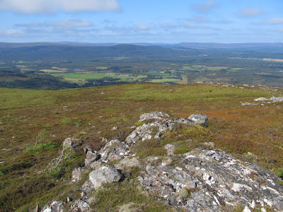
As soon as I crossed the Allt Druidh I began climbing the steep bare earth bank beyond, which proved to be a mistake. This was really steep and the crumbly soil made climbing very difficult while midges attacked me from all directions until eventually I reached the top of the bare earth bank and discovered a good path that I should have been on. This well-made path took me steeply up the hill, frustratingly still surrounded by mist, as I slowly climbed until finally, at about three thousand feet above sea level, I emerged from the clouds to stupendous views with an uninterrupted sea of clouds to the north. Looking back over the clouds the only points I could see were the Munro and their tops: Creag an Leth-choin (Lurcher’s Crag) was to my right while to my left was the northern slopes of Braeriach while in the distance were the twin peaks of Sgòran Dubh Mór and the Munro Sgor Gaoith. I was looking at a stunning sight and once I reached the edge overlooking the Lairig Ghru I stood there for ages just taking in the tremendous views until finally I tore myself away and continued the climb up the hill towards the top of Sròn na Lairige.


Keeping to the path that bypasses the top I made my way across the col and up the rocky slopes to the edge of the awesome Garbh Coire where I now had views across to the fourth and fifth highest peaks in Britain: Cairn Toul and Sgor an Lochain Uaine while in between them I could see the dome of Beinn Bhrotain. Across the Lairig Ghru I could see Ben Macdui, the second highest mountain in Britain, and the Cairngorm plateau where I had walked the day before. If I hadn’t gone up Ben Macdui with Abbie Barnes I would have approached the mountain via Loch Etchachan and I considered doing that walk on this day, but the thick mist and the sight of Braeriach the day before had convinced me to leave that approach up Ben Macdui for another time. Turning west I made my way up the ridge towards the top of the third highest point in Britain: Braeriach, which I had last summited in 2009, though in misty conditions, so I was now able to enjoy Braeriach in fabulous weather and to make the most of the conditions I set off across the vast, high plateau crossing to the cairn on the 1,235 metre top at the northern end of a shallow ridge.


Turning south I headed across the featureless terrain with little vegetation to the Einich Cairn on the 1,237 metre top, past a third cairn on a negligible top and after passing the Wells of Dee I headed up to the 1,265 metre Carn na Criche. Since I was returning the way I had come I decided it wasn’t worth descending to bag Sgor an Lochain Uaine or Cairn Toul, so I turned north to cross the infant River Dee and climbed back up to the top of Braeriach where I once more admired the stunning views of the thermal inversion. The views were still mesmerising with the clouds looking particularly fluffy south-east between Ben Macdui and Cairn Toul where no other mountains could be seen stretching all the way into the distance. As I slowly made way around the edge of Garbh Coire I continued to gaze out across this awesome view until eventually I turned my back on it and headed down to the col and up to Sròn na Lairige veering off this time to reach the summit before returning to the path to continue my descent. It soon became obvious to me that the mist was higher than it had been earlier in the day, now more than a thousand metres up, so soon I became enveloped by the surrounding clouds and I was robbed of the tremendous views.


Although I had now descended below the cloud level, since I had an excellent path to follow and I was in a good state of mind I was happy for this to happen having thoroughly enjoyed my traverse of the Braeriach plateau. However, in my eagerness to descend I tripped and went sprawling across the rocky ground grazing my arm. Since this seemed to be the extent of my injury I brushed myself off and continued the descent taking the excellent path all the way down into the Lairig Ghru and after a short descent beside the stream, up the very good path that climbs up to the Chalamain Gap. At this point I started having problems with my right boot that seemed loose no matter how much I tied the laces. I had brought an old pair of walking boots with me and they were slowly disintegrating. I had been worried they might fail on the walk up Ben Macdui the day before, but had held up until now as on closer examination I saw that the sole had worn all the way through and may have contributed to my earlier fall. Having a loose boot made crossing the boulders in the Chalamain Gap tricky, but once I was on the good path beyond I had no problem and I was easily able to descend all the way back to the campsite where I had some trail shoes to change into and the boots went in the bin.

Unfortunately my problems were not over as soon after leaving the Chalamain Gap I realised that the back pocket on my trousers had been torn during my fall and my wallet was missing. It was too late to go back for it, but it wasn’t a disaster. My train tickets were on my phone and a week later my wallet arrived in the post curtesy of a fellow walker who had also enjoyed the stunning views above the clouds from the top of Braeriach. The thick mist that persisted in the valleys all day, and my deteriorating boots, had put a dampener on what otherwise was a great day. I was fortunate to see such a stunning thermal inversion on this walk and when I look back over the whole fortnight of my holiday it is astonishing to realise how good the weather was every day. It hardly rained the whole holiday and to have that happen in Scotland is amazing and my final three days in the Cairngorm Mountains capped off a thrilling fortnight.

Thursday 23 December 2021

Ben Macdui with Abbie Barnes

Thursday 2nd September 2021

I have enjoyed watching the YouTube channel of Spend More Time in the Wild by Abbie Barnes for several years and particularly enjoyed her films of her walks along the West Highland Way and the Coast to Coast Walk, and I found much solace in Abbie’s live streamed videos from the start of this year during the darkest part of the lockdown even buying a Spend More Time in the Wild hoodie in March when they became available. Then Abbie announced last summer that to raise awareness of mental health issues she was going to cycle from the top of Scotland all the way down to Land’s End in Cornwall and on the way she would be walking up to the highest point in all fifteen National Parks in Britain. When the dates were revealed for the walks, I realised that the ascent of Ben Macdui in the Cairgorm Mountains would be while I was there and when I had already planned to go up Ben Macdui. My plans for visiting the Cairngorm Mountains, made at the beginning of 2020 put on hold for a year, had centred on a desire to return to Ben Macdui after previously reaching the top in 2005.


When Abbie put out an invitation to join her on the walks, I decided I had to sign up for it and follow her, not only on YouTube, but in person up Ben Macdui. The time that Abbie had specified for us to meet was 7.30 in the morning, so I got up very early and set off up the road to eventually reach the upper car park beside the Cairngorm Mountain ski resort. The weather was poor with a thick mist, but a temperature inversion was forecast so once we got above the clouds we were promised lovely sunshine. At the car park I soon found someone wearing a Spend More Time in the Wild hoodie and when she saw my Stay Wild t-shirt we knew that we were both walking with Abbie. Rachel introduced herself and said there was one other person, John, who soon joined us as we waited for Abbie and her partner, Anna, to arrive. We had to wait a while, and even after Abbie arrived we had to wait even longer before we could start, during which I got very cold, which prompted me to put on my fleece and waterproof until eventually after an hour stood waiting in the car park, we set off.


Along with the three of us who had signed up to join Abbie, there were two camera men helping Abbie make a video of the walk, a qualified mountain leader and two rangers from the Cairngorms National Park. Soon the mist had begun to clear and we were out in the sunshine walking on the path that crosses in front of the Northern Corries of the Cairngorm plateau with our shadows creating faint Brocken spectres in the mist. I have seen this optical effect several times with the best one being on An Stac in Moidart in 2016. This spectre was poor in comparison, but others were far more interested, perhaps never having seen one before. In the sunshine, I soon warmed up so eventually I decided that I had to stop and take my fleece and waterproof off, which prompted everyone else to do the same, with some of us, including Abbie and I, walking in our Stay Wild t-shirts. The views behind us were stunning with the mountain range that I had walked over the day before, Meall a' Bhuachaille, appearing as an island above a sea of clouds. The views got better and better as we climbed up the ridge marked on Ordnance Survey maps as Miadan Creag an Leth-chain towards the top of the cliff above the Lairig Ghru where we stopped to let Abbie conduct an interview with the National Park rangers.


This was a stunning location looking across the deep pass of the Lairig Ghru to the mountains of Braeriach and Cairn Toul and north down the pass into the valleys that were still filled with cloud. I wouldn’t normally stop for as long as this, but in this fabulous location I didn’t mind as it allowed me to absorb the tremendous scenery of the high mountains and the cloud covered valleys. I travel very quickly over mountains and never stop for more than a moment or two to take in my surroundings, so I appreciated the opportunity that our slow progress up Ben Macdui was giving me. When the rangers started heading back down we resumed our climb towards the hidden top that doesn’t lend its name to the range despite being the highest. A featureless terrain had to be negotiated that was relatively easy given the good weather as we crossed the boulder field until eventually we reached the top of Ben Macdui where we had extensive views in all directions including to the west where Ben Nevis could be made out on the horizon. Mist clung to the southern valleys, but had cleared to the north, though while the camera men used their drone to take dramatic shots of the summit my eyes usually strayed to the west.


For our return, the mountain leader decided to take us via the top of the cliffs that overlook Loch Avon where we had amazing views down the length of the loch. I walked beside Loch Avon in 2013, but I had never seen this sight, which is truly spectacular. From the top of Hell’s Lum Crag we crossed over to the top of Coire Domhain where it was decided that we would climb over Stob Coire an t-Sneacha to a barely perceptible 1141 metre top where we descended the ridge of Fiacaill a’ Choire Chais back down to the car park. This walk was a very different experience for me as I have almost always walked on my own and with all the camera work being done it was a very slow one. It was also a very weird experience walking with two people I have seen many times on YouTube, so there were occasions when I forgot I was looking at Abbie for real. Abbie seemed to be completely genuine and just as I had seen her on YouTube. It was wonderful being part of Abbie Bikes Britain and join her in going up Ben Macdui, which will be something that I will remember for a long time. We had stunning weather for this walk as we climbed to the highest point in the Cairngorms National Park and passed some astonishing scenery.

Thursday 16 December 2021

Meall a' Bhuachaille and the Allt Mor Trail

Wednesday 1st September 2021

I had planned to come to the Cairngorm Mountains in May 2020, but those plans were put on hold until this point in my holiday late summer 2021. My first goal in those plans was to climb Meall a’ Bhuachaille, which is a Corbett that overlooks Glenmore towards the Cairngorm massif. This is an easily ignored mountain, as I have done over many years, as it is much smaller than the main Cairngorm Mountains and lacks the crags that adorn the northern corries. The most direct route from the Glenmore Campsite ascends beside the Allt Coire Chondlaich burn, but first I wanted to take a path that I remember enjoying on my previous visits to the area and is marked with blue posts. I particularly remember, in 2013, doing the walk as soon as I got to the youth hostel, leaving my rucksack behind I headed straight out onto the path. From the visitor centre it passes the Cairngorm Reindeer Centre climbing a wide track through a conifer plantation that isn’t a promising start, but soon passes into more open and delightful woodland while the path narrows and weaves an interesting route around the trees. In 2013, it was May and the ground was littered with many colourful wild flowers that delightfully decorated the path, but now the only flowers were those of heather, though bright red mushrooms did provide some extra colour to the scene.

It is still a great path, but woefully short, and soon I was descending to the Ryvoan Pass and the shore of An Lochan Uaine. The weather initially on this walk was overcast with low clouds and although these would eventually lift, they were slow to do so. Taking the clear track through the Ryvoan Pass, I ignored the path that heads south towards the Lairig an Laoigh, and instead headed up to the Ryvoan Bothy where I turned left onto a clear, well-made path that climbs steeply through heather while the views opened out towards the Cairngorm Mountains, although they were persistently holding onto their cap of clouds. Slowly, I made my way up the path plunging into the clouds and eventually reached the summit of Meall a' Bhuachaille, which is a Corbett meaning it is a mountain in Scotland between two and a half and three thousand feet high. I was surprised to see a large group of people at the summit and some of these seemed to follow me, sometimes ahead of me, sometimes behind me, all the way over and down the mountain. The clear, well-made path descends to the top of a pass where it turns left to descend back down to Glenmore beside the Allt Coire Chondlaich burn while I and a group of young men continued ahead on a sketchier path up to Creagan Gorm.


The young men stopped at the summit cairn while I kept going along the ridge, but like the fabled hare and tortoise, they would eventually overtake me again. The undulating ridge passes over several tops and these young men seemed to stop at everyone while I kept going until I reached a cairn near the top of Craiggowrie where I decided to stop for lunch even though it was not quite noon yet, but I had been walking since before eight. While eating, the sun finally began to appear so that by the time I climbed up to the top of Craiggowrie I had clear views north across the Abernethy Forest and Strath Spey under gorgeous blue skies, though behind me mist still lingered around the Cairngorm Mountains. Turning left I began to descend long peaty slopes under warm blue skies thoroughly enjoying the gentle descent that reminded me of other great walks, even though it was very boggy in places. Eventually the young men caught up with me again as the tortoise and hare routine continued just before we reached the bottom of the hill and entered the conifers of Glenmore Forest Park.


Now a long walk-out ensued whereby I, and the young men, who were coincidentally going in my direction, followed forestry tracks past Badaguish Outdoor Centre back to Glenmore in the warm sunshine. Although the walk had taken me six hours, which is a decent length of time for a walk, it was only two o’clock, so since it was still very early, I decided to walk along another trail that I remember with fondness from previous visits (and also to see how long it would take me to reach the Upper Car Park). I have fond memories of a path called the Allt Mor Trail, so I set off up the road eager to make its acquaintance again. Immediately after crossing the Abhainn Ruigh-eunachan, I turned left onto a slender path through the trees that didn’t seem to be well-used and is not marked on local maps, but was clear and eventually brought me to a car park and the Allt Mòr burn. However, there I found a sign that said: “The Allt Mor Trail is no longer maintained by Forestry & Land Scotland: It may be difficult underfoot & is not safe beyond Utsi’s Bridge”. This was disappointing, but I persevered to see what it was like and soon discovered that the path had been severely eroded by flooding, though was still passable with care.

Beyond that point the path was good including on the boardwalks that climb steeply up the hillside, but after crossing the road the path seemed very overgrown and more signs of erosion could be seen as the path drew alongside the burn again. I remember being delighted with the Allt Mor Trail previously as, to quote my blog from 2009: “The path climbs through a wonderful, wooded valley that has been totally given over to nature with absolutely divine results,” but nature doesn’t do neat and tidy and so the path is now in a poor state and is not worth maintaining. Nature has completely taken over the path and in some places there is not much of it left. When I reached Itsi’s Bridge, I decided to climb up to the road rather than attempt to proceed any further up the path. Signs warn that the path is not safe due to erosion and land slips and I remember it not being good many years ago. Back on the road, I continued to climb, but soon came off onto a track marked on my map that seemed to be an old road and provided me with a convenient off-road route that cuts a corner until I came back onto the road for the final walk into the car park beside the ski centre.


Behind me, I now had very good views towards Glenmore with Meall a' Bhuachaille and its ridge emerging from above the trees of the forest park. In the fabulous weather, this was a great moment as I gazed across the awesome landscape with the Cairngorm Mountains tantalisingly close, though hazy, looming above me. I could have kept going up, but I was happy to have reached this far, at the top of the road, and I now knew the best route up which would be helpful for the next day when I would be back there very early and then I would climb onto the Cairngorm Mountains. For now, I was content to head back down the road and ignored the Allt Mor Trail to slowly descend all the way back down to the campsite. It is a pity the weather was not at its best when I was at the top of Meall a' Bhuachaille, but it more than made up for it later in the day and I still had a great walk over the mountain.

Thursday 9 December 2021

The Old Logging Way to Loch Morlich

Tuesday 31st August 2021

When making my plans for my holidays in 2020, my Scotland holiday was going to be in the Cairngorm Mountains, but I was never sure what else to do while I was in Scotland. The main goal of the holiday was the heart of the Cairngorms including Cairn Gorm itself and Ben MacDui, the highest point in the Cairngorm Mountains. The reason for this was that it had been many years since I was last there and I felt like I had unfinished business. I first visited the area in 2005 and came back in 2009, but when I returned in 2013 there was so much snow on the mountains, despite it being the end of May, I was unable to visit the highest peaks. When I came back to the Cairngorm Mountains in 2016, I went around Cairn Gorm and its neighbouring mountains, and I had not been back since. That is why the main goal for my holiday in 2020 was to return to the central mountains of the Cairngorms, but then the world was hit by Covid-19 and the holiday was cancelled. This year, with my 2020 plans resurrected, I still had the problem of what else to do besides the Cairngorm Mountains and eventually I decided on the Fife Coastal Path, so after a week in the Kingdom of Fife I set off towards the Cairngorm Mountains.

Finally leaving Leven and Silverburn Park where I had been camping for over a week, I caught a bus to Markinch where I caught a train to Aviemore. I considered catching a bus from Aviemore to the Glenmore Campsite, but with the good weather that I had enjoyed in Fife continuing, I decided to walk even though I was carrying a heavy rucksack and had proved to be a big problem for me on the first day of the Fife Coastal Path. Soon after leaving the railway station in Aviemore, I saw signs for the Old Logging Way, which is a cycle and walkway that parallels the road all the way to Glenmore, which is the most direct route to take. On previous occasions, in 2009 and in 2013 in the other direction, I took a route through the Rothiemurchus Forest via Loch an Eilein. This is a great and picturesque route, but it is not the quickest way to go, so since more than half the day was already spent, and I was carrying a very heavy rucksack, I thought I’d give the Old Logging Way a try. When I first came to the Cairngorm Mountains in 2005, the Old Logging Way had not yet been built, so I had walked beside the road all the way to Glenmore which was really tiring, especially as I was carrying two shopping bags.

The Old Logging Way was a delight taking me out of Aviemore over the River Spey and initially just kept to the pavement beside the road, but then after leaving behind the last of the buildings in Inverdruie, the path moves slightly away from the road to pass through Caledonian pine forest. The landscape was dominated by purple-blooming heather though there was also some in-seed broom and many bright red mushrooms were dotted around on the ground. Slowly, I made my way towards Glenmore passing through more established conifer plantations and moved well away from the road on clearly marked tracks where my biggest difficulty was keeping out of the way of cyclists. After joining a wide track, I came near to the road again beside the shore of Loch Morlich for the final stretch of the Old Logging Way that took me to the Glenmore Campsite. It had taken me about two hours to get there, which was much quicker than I had been expecting as the Old Logging Way is six and a half miles long and I’d heard reports of it being seven miles, so at the slow speed I had been walking it should have taken me much longer, however this was very important information for me as I would need to return along the Old Logging Way at the end of my holiday to catch my train home.


After putting up my tent, having a shower and eating my dinner, I decided to do a walk around Loch Morlich to get my bearings. On the far side of the campsite I found a sandy beach that looked fabulous with the backdrop of the Cairngorm Mountains in the distance. Walking between the road and the shore, I enjoyed the views over the loch as I made my way over the tree roots until I reached a car park where a path emerged marked with red-topped posts. These mark Forestry and Land Scotland’s Loch Morlich Trail and were a reliable guide around the loch when otherwise I might have got lost. They directed me onto a track over the River Luineag and seemed to take me further and further away from Loch Morlich, but it was a lovely walk as I kept going through the conifer plantation while the evening light faded. The red posts never let me down, even when I did as I was convinced that all I needed to do was keep turning left, so when I reached a junction where a new trail of white-topped posts marked left while the red-topped posts turned right, I decided to follow the white-topped posts.


I soon discovered that the white-topped posts had taken round in a circle back to the red-topped posts at a footbridge over the Abhainn Ruigh-eunachan and I could have saved myself some time by keeping beside the red-topped posts. Later, I spotted some caravans hidden amongst the trees, which seemed odd until I realised it was my campsite, so I passed them and returned to my tent. The weather on this day was largely overcast with some blue sky around, but not near the mountains, which was not a problem as I was not climbing mountains on this walk. This day was mainly about travelling from the Kingdom of Fife to the Cairngorm Mountains, but I was still able to get some good walking done. The Old Logging Way was a good route to do even with a heavy rucksack and the Loch Morlich Trail was a wonderfully relaxing walk to do in the evening. At the end of the week, I packed up my tent and set off once again along the Old Logging Way to return to Aviemore and I was once again able to enjoy this very convenient and quick route between Glenmore and Aviemore.

Thursday 2 December 2021

Letham Glen and Kennoway Den

Monday 30th August 2021

On the day before this walk I finished the Fife Coastal Path after seven days on the trail, but I still had another day in the Kingdom of Fife. When I had planned my accommodation in Silverburn Park, near Leven, I had intended on starting the Fife Coastal Path on the Tuesday and with hindsight that would have been better, but instead I actually started the trail on the day before while travelling from Edinburgh to Leven. I should have spent more time in Dalkeith Country Park and Edinburgh before heading to Silverburn Park so I could arrive there on time and not tried to walk along the trail while carrying a heavy rucksack. I had been thinking I could use this spare day to do some walking elsewhere in Fife, perhaps over the Lomond Hills, which are the highest hills in the county. In the end, since the Fife Coastal Path had completely worn me out, I didn’t want to do much walking on this day, so I decided to do something around Leven. From Silverburn Park, I headed past the golf courses to the outskirts of Leven where I turned right along a footpath beside Scoonie Burn that took me into Letham Glen Park.


Initially this was your typical ornamental park with many flower displays, but the path soon passed into dense woodland with surroundings that were more wild and so more appealing to me. I had an enjoyable walk through the woodland of this narrow valley until I reached the end whereupon I turned around and headed back through the glen. It was lovely to be walking through natural, wild scenery, which is something I have increasingly appreciated over the previous eighteen months. It has been vital for my mental health to get out into wild landscape during this time as it provides such a calming and relaxing effect on me at a time when I was forced to spend so much time at home. When I reached the end of the woodland walk I climbed out of the park onto Sillerhole Road. While wandering along this road that becomes Linnwood Drive, I checked on the internet for other walks in the area and found a reference to Kennoway Den, but since I had not planned anything for this day, I didn’t have a map of the area so I was reliant on Google Maps to guide me.

At the end of Linnwod Drive I crossed a road onto a path that passes a large number of warehouses that reminded me of those I have seen at distilleries and Google Maps confirmed my suspicions as the warehouses are labelled Diageo Global Supply. This was a very relaxing walk on a tarmac path between the warehouses and farmland with the sun that had been hiding behind clouds now starting to break through. After swinging away from the warehouses, the path heads to Kennoway and passes alongside the community until it reaches a point where I could come off the path and onto a road near a sign that marks the start of the Kennoway Den walk. Initially this walk was not very promising as the path followed a small burn with a farmer’s field on the other side, but soon the valley deepened with wooded sides that developed into a pleasant walk that simply got better and better. Rock faces appeared with short caves as the valley turned left and right through the gorgeous woodland landscape. I had a really enjoyable walk through the delightful natural surroundings of Kennoway Den as the burn slowly climbs with an excellent footpath that always provided me with easy access through the dramatic scenery.


Eventually the path began to climb above the stream that now plunged into a deep, dark ravine until the path reached a road near Auchtermairnie. Realising that the path goes no further, I turned around and headed back down the valley, much to my delight, enjoying the walk once again despite the earlier sunshine having now gone leaving gloomier skies. Veering to the east of the stream I came out onto a grassy area near some houses and keeping beside the stream I walked along the edge of the grass and returned to the main road where I had started the walk through Kennoway Den. These had both been very enjoyable and relaxing walks through wonderfully wild wooded glens, but it was now only twelve o’clock and I had no idea how to fill the rest of the day. Returning to the path that I had been on earlier, which at this point is an old railway line, I turned right heading down this path under a road and near to an area identified by Google Maps as Cameron Wood where there used to another old railway line, but I don’t recall seeing any sign of it. Instead I crossed over the River Leven and walked along the top of a pipeline that parallels the river until eventually the pipeline crosses the river and I was left to find my own way through the overgrowth and past a recent housing development.


With a faint path to follow I ploughed on until stopped by a tall fence surrounding a water treatment works that forced me to turn right and climb up to the road opposite a bus depot. I was now able to make my way back into Leven where I had my lunch, but I was preoccupied with some blisters that I had recently acquired on my toes. As I headed off again I was in quite a bit of pain so I returned to Silverburn Park where I tended to my injuries while sat beside my tent. Since I refuse to waste an afternoon, I got out my walking pole and hobbling like an old man I made my way back onto the beach using the pole for support and gradually it became easier for me to walk as I crossed the sands up to the sea. Despite the overcast skies, it was great to be back on the beach and I was reminded of the walks I had done during the previous week on the Fife Coastal Path, so as a memorial to that trail I headed along the beach until I ran out of sands and crossed the rocks to the mouth of Kiel Burn below Lower Largo. Unable to keep going along the coast, I climbed up into the village and continued to climb up to the main road where I turned left and followed it all the way back to Silverburn Park. This walk ended a fabulous week in the Kingdom of Fife where I enjoyed some fabulous walking with great weather every day and I appreciated the chance to relax on this day to recover from my exertions of the previous week.

Thursday 25 November 2021

The Fife Coastal Path: Newport-on-Tay to Newburgh

Sunday 29th August 2021

I started my trek along the Fife Coastal Path on the Monday before this walk, and at the end of the sixth day on the trail I had reached the village of Newport-on-Tay. After walking ninety-eight miles, I had just over eighteen miles left to go, but first I had to get back to Newport-on-Tay and since it was a Sunday morning I was not going to get there early. The only way I could do it was to catch a bus from Leven to Dundee on the far side of the Firth of Tay and then catch another bus back across the Tay Road Bridge to Newport-on-Tay where I was finally able to begin my last stage on the Fife Coastal Path. Unfortunately, this initially involved simply walking along the pavement beside the B946 road out of the village, which is something I seem to have done a lot on the Fife Coastal Path, though the other bits had more than make up for it. Eventually, I came to the end of the road beside Wormit Bay, soon after passing underneath the Tay Rail Bridge, where there is a memorial to the Tay Bridge disaster of 1879 when the original bridge collapsed killing all on board the train that was passing over it.


From my vantage point beside Wormit Bay, I had good views of the replacement bridge and of the piers for the original bridge alongside. Beyond this point the trail continues beside the Firth of Tay on an interesting path that undulates beside thick hedges before crossing a small ravine near Jock’s Hole to enter Scurr Wood and reach the tiny community of Balmerino. Beyond there the path enters Oak Wood, which is a fabulous place that I loved immensely. It was full of vegetation that made the whole place seem like a sea of green, while the path weaved up and down through the delightful surroundings. This was such a wonderful woodland walk that I almost forgot I was supposed to doing a coastal walk until the path briefly dropped down to the shore before climbing back up the side of the hill and I would not be back beside the shore for many hours. The gorgeous scenery was eventually left behind, much to my distress, as I slowly climbed the hillside to rise far higher than the trail had ever done previously. Relentlessly I continued to climb along a gravel track until I reached a quiet road where I decided to stop to catch my breath and to have my lunch before proceeding along the road for several miles of tedious walking.


The lovely green-overload of Oak Wood was a brief respite from the grey, overcast skies overhead and now that I had moved away from the coast there was no incentive for me to take any more pictures until Newburgh was in sight. The views while walking on the road were not exciting as I passed beside green fields until eventually I turned off the road onto a track that climbs towards Norman’s Law, but before I reached the top I turned right onto a track that skirts around the hill passing the highest point on the Fife Coastal Path before gradually descending through conifer woodland as the sun finally began to break through the clouds. After the tracks had taken me down the hill, I passed through farmland before climbing once again around the eastern slopes of Glenduckie Hill and up the grassy slopes of Higham Hill to the top where the view opened up across the Firth of Tay and I was rewarded with a stunning sight. Before me was the wide estuary of the Firth of Tay where various mud banks and the reed-filled Mugdrum Island could be seen looking splendid in the sunlight as I made my final descent into Newburgh beside Lindores Hill.


Once I was at the bottom of the hill, I came up to the shore of the Firth of Tay for a final, celebratory walk beside the estuary that provided me with a taste of coastal walking that I had been missing for many miles on the Fife Coastal Path before finally I reached Mugdrum Park where I passed under the arch that marks the end of the trail. The last two days on the Fife Coastal Path were not great, though Oak Wood is a fabulous example of ancient woodland that was a joy to walk through and the descent into Newburgh with the wide views over the estuary also made up for the earlier road walking. Looking at the whole trail and there were some fantastic moments that justify the acclaim that is given to the Fife Coastal Path though these are mainly beside Aberdour and St. Andrews while outside of those areas there is not enough coastal walking and too much tarmac. Originally the trail ran from North Queensferry to Tayport and I don’t think anything has been gained by extending it to the borders of the county in Kincardine and Newburgh. I am most astonished by my fortune in the weather during my seven days on the trail during which it never rained, which is rare in Scotland. It was a very tiring walk with high mileages each day, but it was a very enjoyable even at its most tedious when it was still very relaxing.

Thursday 18 November 2021

The Fife Coastal Path: St. Andrews to Newport-on-Tay

Saturday 28th August 2021

After the challenges of the rough and remote coastline between Crail and St. Andrews, the Fife Coastal Path now deteriorated to become more like the abundant tarmac of the start of the trail. I had reached the golfing town of St. Andrews on the previous day, so now I caught a bus back there to resume my walk along the Fife Coastal Path that started with me passing the Old Course, which is the oldest golf course in the world, before settling down to walk along a cyclepath beside the A91 road. I was already finding this walk rather tedious as this part goes on for several miles, though for some of the way there was a line of trees between the path and the road, but this deteriorated to become a low hawthorn hedge, later a low wall, then a wire fence and eventually an unprotected path beside the road. All of this while crossing flat, open expanses of grassland with little or no view until finally I came to Guardbridge and crossed the fifteen century bridge where I had views across the supporting piers of the old railway viaduct over the River Eden.

The Fife Coastal Path makes use of the course of the old railway for its route through Guardbridge and provided me with me with a good off-road path, but all too soon I was back beside the road and branched off to take a minor road into the small town of Leuchars, which is dominated by the military base of Leuchars Station. This seemed rather intimidating with tall fences topped with barbed wire either side of the road and manned entrances, though the jet plane parked behind the entrance was very impressive. I followed the road around the base turning to the east to come out of Leuchars, until I eventually came to the end of the road and with one last look at the airfield I continued on a track that heads into Tents Muir. When the trail comes off the track I took to a delight path through extensive dunelands where there was a mixture of trees and grass with many marshland plants. This was an interesting terrain that compensated for the flat gradients on a path that took me across the wild landscape on boardwalks until I reached the much less diverse conifer plantation of Tentsmuir Forest.


I was now on wide forestry tracks and this wasn’t helped when I turned right onto a road where many cars seemed to pass me as I headed along the road to the busy car park for Kinshaldy Beach. Coming off the coastal path, I headed across the dunes and onto the beach, which was vast enough to provide plenty of space despite the large numbers of people, so I was able to find somewhere to sit and have my lunch. After eating, I headed up the sands enjoying the expansive views and slowly drifted towards the sea where I took in the gently lapping waters and took many photographs before heading back across the sands. Crossing the dunes again, I re-entered the forest, but I was not back at the car park or on the Fife Coastal Path. However, soon after entering the forest I found a red-topped post marking a trail that was much more interesting than the coastal path. While that follows wide forestry tracks, this trail takes an interesting route weaving through the trees and I thoroughly enjoyed following it until beside a Second World War observation post it takes a sharp left turn. At that point I headed back out of the forest to have a look across the dunes towards the distant sea, before taking the path back onto the coastal path beside an old ice house.


Now, I followed the trail along tedious wide tracks through the commercial forest, though never far from the edge up to Tentsmuir Point where I couldn’t resist the temptation to head out onto the sands once more where I was greeted by the sight of the wide expanse of Headwell Sands that incongruously had a herd of cows on it and was lined by concrete anti-tank blocks. Across the Firth of Tay, I could see the coastline of the county of Angus that seems heavily populated compared with the coastline of Fife that I had been enjoying all week. Resuming my walk along the trail I finally headed out of Tentsmuir Forest, to walk beside the coast with wide views across the estuary and with more concrete blocks lining the route. This took me into Tayport where the coastal path keeps to the edge of the coast passing through Tayport Links Caravan Park and along the Promenade to the harbour. I had considered ending the walk this day in Tayport, but since it was only three o’clock, I decided it would be best to keep going, so I headed out of Tayport on the route of an old railway line.

In something reminiscent of the start of the day, this later led to my walking beside a road, but now with the heavily developed coastline of the city of Dundee across the Firth of Tay. I continued beside this road under the Tay Road Bridge and into Newport-on Tay where I had decided to end the walk for the day leaving me with the same distance to walk on my final day as I had just walked on this day. However, first I had to find a bus, but that proved difficult especially after seeing a bus I should have caught but not realising until after it had passed me, which left me with an hour to wait for the next one. This was a very tedious walk with hardly any changes in gradient and the only highlight on the trail was while passing through the moorland of Tents Muir. Off-trail, the highlight was the Ice House Trail through Tentsmuir Forest that is marked with red-topped posts, but elsewhere the Fife Coastal Path keeps to wide tracks and pavements which is a great deterioration since its heights of my previous few days along the trail and I wasn’t hopeful about the last stage.

Thursday 11 November 2021

The Fife Coastal Path: Crail to St. Andrews

Friday 27th August 2021

To resume my trek along the Fife Coastal Path, I caught a bus from Leven, where I had been staying at Silverburn Park, to reach the village of Crail, where I had left the trail the previous day. Unfortunately, the bus schedule in that part of Fife is so infrequent that I had to catch a relatively late bus which meant I didn’t reach Crail until half ten, halfway through the morning. I had some confusion about the route of the Fife Coastal Path through Crail with some maps indicating that it heads towards the harbour, however the Footprint map that I was using directed me to the parish church and then down the narrow lane of Kirkwynd to the coast at a viewpoint that looks out to the North Sea. Passing through Sauchope Links Caravan Park there was a very cold wind coming off the sea that prompted me to wrap up and even to put on my gloves for the first (and only) time on this holiday. Beyond the caravan park, the trail passes through Kilminning Coast Wildlife Reserve before reaching Fife Ness where the coastline turns its back on the Firth of Forth, and the cold winds, to head towards St. Andrews Bay and the Firth of Tay, but on the way I had to negotiate a lot of golf courses. I had already encountered many courses on the trail before this day and now I came across many more with the two courses of the Crail Golfing Society the first that I had to avoid.

Immediately after Fife Ness, the coastal path passes perilously close to Balcomie Links, though it also passes Constantine’s Cave, which is close to the fourteenth hole. To avoid the golf balls, I came off the trail and onto Balcomie Sands, though I was soon back on the path and having to keep a constant look out for anyone who might be teeing off as I was passing. This section between Crail and St. Andrews is very challenging with several places where it is impossible to pass at high tide and there are no facilities near the route, which was in stark contrast to the earlier sections of the trail that for long stretches was on tarmac. Near Randerston Castle, I descended onto the beach on the first stretch of the trail that would be impassable at high tide, but was not a problem for me as the tides were perfectly timed for me on this holiday. When the Fife Coastal Path finally came back off the seaweed-filled beach, I had another golf course to negotiate, Kingsbarns Golf Links, but this time I was diverted around the golf course heading inland before passing through the delightful wooded valley of Cambo Burn. Beyond this point I could have kept away from the golfers by descending onto Cambo Sands, but instead I decided to keep to the clear path between the golf course and the sands that brought me to a car park beside the old Kingsbarn harbour.


The overcast skies that had stubbornly refused to clear during the morning now broke to reveal clear blue skies and bright sunshine that made the golden sands at Airbow Point look particularly stunning. The whole coastline now looked fabulous with the craggy foreshore that I had admired the day before now repeated along the coast all the way to St. Andrews. Upon reaching Kenly Water, I turned inland to follow the stream along a delightful path through a wooded valley that was more keenly appreciated because woodland had been rare on the coastal path since before Leven. After climbing away from Kenly Water, the trail could have been tedious as it passes over Chesterhill, but this was compensated by the warm sunshine before descending back down to the coast near Buddo Rock. This prominent stack has a wide crack that I explored thinking that it would be easy way to get up to the top of the rock, but I soon stopped myself attempting the climb for fear that might I get into difficulty, so I hastily retreated and continued along what is a sensational section of the Fife Coastal Path.


Although there are three golf courses beside this stretch of the coast, the path is safely away from danger partly down the steep escarpment and negotiates an interesting route through a wild landscape climbing up and down the steep terrain on well-weathered steps. This was an absolute delight to traverse with many wildflowers at my feet and great views across the rocky coastline including the tantalising view of the University town of St. Andrews in the distance. The constant movement of the path up and down provided me with good exercise that got my heart pumping and my excitement jumping. When I finally came back down to the coast I passed the curious rock feature of the Rock and Spindle and was now so close to St. Andrews that I eagerly made my way along the path and into the town. After enjoying the view across East Sands, I crossed Kinness Burn and passed the ruins of St. Andrews Cathedral and the castle. This was a short walk compared with the previous few days, but the late start and the rugged nature of the path had compensated for that. I thoroughly enjoyed this walk that passes through fabulously remote and rugged scenery and I now appreciated why the Fife Coastal Path is so highly acclaimed, but I wasn’t optimistic about the next two days as I suspected the best of the trail was now past.

Thursday 4 November 2021

The Fife Coastal Path: Leven to Crail

Thursday 26th August 2021

To continue my trek along the Fife Coastal Path on this day I didn’t need to catch a bus anywhere since on the previous day I had finished the walk in Leven, which is where I stayed for the whole of my time in the Kingdom of Fife. Therefore, all I needed to do was to return to the seafront and I would immediately be able to continue along the coastal path. Earlier in the week the days had started misty and foggy and only cleared later, but on this walk there was no fog and just a little cloud that eventually cleared to reveal a gorgeous sunny day with clear blue skies to accompany the fabulous scenery on this stretch of the coast. When I had reached Leven the previous day the tide had been in, but now the tide was on its way out so I was able to walk out onto the sands for a lovely walk along the sandy beach, before eventually coming off back onto the footpath and across a golf course into the small village of Lundin Links that merges into the village of Lower Largo. After passing a statue of Alexander Selkirk who was the inspiration for Robinson Crusoe and was born in Lower Largo, I left the village on the course of the Fife Coastal Railway until I reached Dumbarnie Links Wildlife Reserve. There I dropped back down onto the beach and was unable to resist the opportunity to cross the sands right up to the gently lapping sea thereby cutting the corner, slightly, of the wide sweep of Largo Bay.
I had tremendous views across the sands and thoroughly enjoyed my walk beside the sea, but eventually crossed the sands again to take a path that crosses Cocklemill Burn and through a line of trees to pass through Elie Holiday Park. On the far side of the caravan park the path continues around Shell Bay to Kincraig Point where I had an awesome view before me of a complex, rocky coastline. The path climbs above the crags to the top of Kincraig Hill, but there is an alternative route through the rocky inlets, though at first I missed the steep path down. When I spotted the chains on the route far below me, I retraced my steps and slithered down the eroded path to the start of the Elie Chainwalk. This unique scramble crosses the craggy coastline with the aid of large chains that have been anchored to the rocks and provided me with some exhilarating adventure. The rocky terrain was very grippy and has steps cut into it, but I could not have easily got over the vertical rock faces without the help of the chains. I had never come across this sort of thing before, though they are common in the Alps where they are known as via ferrata, though this chainwalk is relatively easy and does not require the usual equipment (lanyards, helmet, and harness).

I found the Elie Chainwalk exciting, though scary in places and nerve-wracking, but utterly thrilling. It seemed to go on for a long time with no sign of where the route went next, so it was always reassuring when I discovered the next set of chains and towards the end I was wondering how much further it had to go. Eventually the sands of West Bay came into view and I was able to walk away from the Elie Chainwalk having survived the challenge. After crossing the sands of West Bay I climbed up off the beach and around the headland of Chapel Ness into Earlsferry where a prolonged section of road walking took me through the popular harbour town of Elie. Branching off the coastal path I walked around Elie Ness passing a lighthouse and the ruin of Lady’s Tower before continuing along the trail past Sauchar Point. The coast was now very complex and craggy, which I found utterly spellbinding. The sun was bright overhead lighting the stunning scenery of the craggy shoreline perfectly as I made my way beside the coast and this mesmerising landscape would continue for the rest of the day as with every turn more delights opened up before me.
The stunning coastline was punctuated by the occasional village and St. Monans came after Elie and after that was Pittenweem and Anstruther. This last village was slightly larger and more crowded where another prolonged section of road walking was required before I eventually left the narrow streets behind and was back beside the same rocky coastline. The inland scenery was now less wild and more agricultural, or to put it another way: it was more bland. This detracted from the craggy coastline to my right and even this was becoming tedious as it was more of the same that I had been seeing for many miles. The only relief from the monotony was the Cailplie Caves, which are made of red sandstone reminiscent of Wemyss Caves that I had seen earlier in the trail. Eventually I entered the village of Crail and since I had now walked at least twenty miles I decided it was time to head back to Leven. When I checked the time of the next bus I discovered that it wasn’t for another twenty minutes, so I descended to the harbour to have a moment looking out over the sea before climbing back up to the main road to wait for the bus back to Leven.
This was the Fife Coastal Path at its best and fully justified my devoting a whole week of my holiday to walking its length. I was fortunate to have stunning weather and to have the tides falling perfectly that enabled me to explore the sands throughout. The constant tarmac of my first couple of days on the trail was now a distant memory as the delights of the coastal path continued to enthral me. The highlight of this walk was clearly the Elie Chainwalk, which I found to be exciting, terrifying and utterly thrilling. Significantly I was now more than half way along the Fife Coastal Path and I had little more than fifty miles left to go.


Thursday 28 October 2021

The Fife Coastal Path: Aberdour to Leven

Wednesday 25th August 2021

I woke up at the start of this day to, once again, foggy, overcast conditions in the Kingdom of Fife as I caught a bus from Leven to Aberdour where I had previously left the Fife Coastal Path. I was unable to immediately set off along the route of the trail because of damage to the Dour Bridge that necessitated a diversion alongside the railway line and down Hawkcraig Road to the sea where I finally found a path that has enough dramatic scenery to deserve the title of a coastal path. Previously on the trail there had been rather too much inland walking around industrial developments with far too much tarmac and was not wild enough for my liking. The path around Hawk Craig was much better with tall crags rising above me and many wildflowers at my feet. I was finally seeing why the Fife Coastal Path is so highly praised and why it had attracted my notice. I enjoyed the walk around Hawkcraig Point and after passing a lighthouse joined a road that took me to Silversands Bay and at the far end I came alongside the railway line.

The poor, foggy conditions did nothing to spoil my enjoyment as I walked between the railway line and the shore with trees towering above my head and thick woodland climbing steeply above the railway. The delights continued after I crossed the line sandwiched next to the steep wooded terrain as I continued beside the railway line until I reached the outskirts of Burntisland. Soon after reaching a road I felt my backside getting wet and was reminded of my first day on the Fife Coastal Path when a similar thing happened, so I stopped and thoroughly examined my drinking vessel, but I could find no source of a leak so I put it back in my rucksack and as the day progressed the pressure of the water on the bladder lessened and the leak stopped. Following the streets through Burntisland I headed out to the beach and after a short spell on the promenade I descended onto the wide beach to take advantage of the low tide by walking between the breakwater stones and the wet sands. At the northern end of the beach I came across drier sand where I was able to move away from the coast and enjoy the walk across the sands taking in the views across Burntisland Beach.


Eventually I came off the sands and climbed up to the road around Pettycur and into Kinghorn where there were stunning views across the bay towards a tall viaduct that looms over the small harbour. The spectacular coastal scenery continued with many colourful wildflowers lining the path above a rocky shoreline with the railway line keeping to my right until it finally leaves the coast and I walked up past Seafield Tower and approached Kirkcaldy. With a hopeful glimmer of sunshine I stopped beside Seafield Car Park to have my lunch before resuming my walk into Kirkcaldy and along the wide Esplanade between the beach and the road. Unfortunately by the time I reached the harbour the sun had disappeared again and the fog remained as I passed a flour mill on my way to Pathhead Sands where another low tide option took me across the beach to Ravenscraig Park. I was fortunate that the timings of the low tide during the week of my walk were ideal to enable me to always take the low tide options when presented and I relished the opportunity given.


Ravenscraig Park is largely wooded with distinctive red sandstone and provided me with tranquil surroundings until after I passed through a low tunnel and suddenly emerged in Dysart Harbour. I was in awe of the complexity of this harbour as I made my way around and past the distinctive red-tiled buildings that look out to sea. Another excellent coastline took me to West Wemyss while the sun slowly started to win its battle with the clouds and afforded me with some sunshine as I walked along the coast past a section of the path that has suffered some erosion and into East Wemyss. Just beyond this village is Wemyss Caves, which is made from the locally common red sandstone and is greatly acclaimed. I stopped for a short exploration of Court Cave and Doo Cave before climbing up to MacDuff Castle but then turned around and came back down to look for Well Cave and Jonathon’s Cave. There didn’t seem much to see in these latter and I soon climbed back up away from the coast and onto an old railway line that took me into Buckhaven.


My map indicated that I would now be stuck on roads all the way into Leven, however soon after reaching Buckhaven I discovered a green path that took me around the settlement beside the coast and saved me from some tedious pavement walking, but was only temporary. Soon, I came out of the park and onto roads that took me into Methil and on until I eventually passed over the River Leven and into the town where I was staying. On this walk I finally saw that everything I had heard about the Fife Coastal Path was true and I felt fortunate to be walking it in such dry and warm weather. It may have been very misty for much of the day, but this didn’t detract from the delights of the walk and I thoroughly enjoyed it despite walking over twenty miles. My original plan for doing the Fife Coastal Path had been for much shorter walks, but I had not planned to end my first day after only eight miles. Instead I had planned to stop at North Queensferry after sixteen miles and the next day to do another sixteen miles as far as Kinghorn leaving a shorter day into Leven. To still end a stage in Leven, I had added seven miles to this stage and just one to the previous day, but such was the quality of the coastline and the good weather I hardly felt the distance and I could hardly wait to keep going.

Thursday 21 October 2021

The Fife Coastal Path: Cairneyhill to Aberdour

Tuesday 24th August 2021

For the whole time I was doing the Fife Coastal Path I was based in one place: at the campsite in Silverburn Park near the town of Leven and I had spent the previous evening to this walk going around Leven exploring where I was going to be staying for the next week. It was a lovely sunny evening and I took full advantage of the good weather to have a pleasant stroll through the town and along the coast. The following morning it looked like it was going to be just as sunny, but mist had soon rolled in by the time I caught the bus back to the village of Cairneyhill in West Fife where I had left the Fife Coastal Path the previous day. Therefore it was under grey, overcast skies and with heavy fog, similar weather at the start of the walk the day before, that I left Cairneyhill and rejoined the Fife Coastal Path. The dull weather was not a problem at first as I was just walking beside the A985 road, around the tiny village of Crombie, before finally coming off the road onto tracks that took me to the coast at Charlestown. To make the most of this historic place, I came off the trail onto a rough path that descends steeply to the harbour and was a welcome change to the tedious roadside walking of the trail. Beside the harbour I should have turned left, but instead I turned right until it became obvious that I couldn’t get far that way so I turned around and passing the bottom of the path reached the quaint harbour.


On the other side of the road from the harbour is a line of well-preserved limekilns that was an impressive sight, especially in the mist, though I would have got a better view of them, if it hadn’t been so foggy, if I’d walked out to the far side of the harbour. Instead I followed the road back onto the coastal path and into the village of Limekilns while the views into the Forth Estuary continued to be misty and moody over the rocky shoreline while steep wooded cliffs lay inland. Leaving the road, the trail became more interesting underfoot as it contours around Bruce Haven until eventually after passing Rosyth Old Church the path begins to steadily climb away from the estuary. Since the coastal path is generally flat, any uphill sections come as a bit of a shock to the system, but fortunately, unlike the day before when I was weighed down with a ridiculously heavy rucksack, I now had a light rucksack on my back so I ploughed on up the hill and was rewarded with clear views across the countryside and blue skies overhead while the mist lingered in the estuary. The trail returned to the A985 road, which I followed past an entrance to Rosyth Dockyards and around the naval base through Rosyth tediously walking on pavements throughout. This is not my idea of a coastal path and I was getting rather frustrated with the abundance of tarmac, however in the distance the bridges over the Firth of Forth beckoned me on.


The newest bridge, the Queensferry Crossing, is the tallest and could be seen emerging from the mist as I followed the road past St Margaret’s Marsh and under the access road for the bridge gradually descending towards the village of North Queensferry. After passing underneath the older Forth Road Bridge I eventually reached the harbour that is the centre of the small community underneath the nineteenth century Forth Rail Bridge that is such an icon of Scotland. There, I had my lunch basking in the sunshine and in the sight of the two road bridges while above me trains rumbled across the Forth Bridge. When I tried to resume my walk along the trail I was immediately confronted with a closed path, so I had to find the diversion, which took me under the Forth Bridge and up a path to the original route that heads into Carlingnose Point Nature Reserve. Now I felt like I was on a proper coastal path as the terrain was stunning with wild scenery around me and a rough path underfoot that was an absolute delight and the only disappointment was that I wasn’t getting a good view of the Forth Bridge as the coast turned away. The stunning terrain continued as I descended to the small bay of Port Laing, while the whitewashed houses of Dalgety Bay sparkled in the sunshine across Inverkeithing Bay.


Unfortunately the delightful, wild scenery soon came to a crashing end when I turned the point of the very Gaelic sounding Ard Alanish into inner bay where industry intruded with Cruick’s Quarry and Jamestown. More tedious road walking took me into Inverkeithing until eventually I came back out to the coast where there was a stunning view back towards the Forth Bridge as I walked along a delightful path past the remains of Prestonhill Quarry and into the town of Dalgety Bay. The trail skirts the edge of the town before plunging into fabulous woodland around Downing Point, but after that I was walking through tiresome residential areas that were not fun to walk through and seemed to go on for far too long. This trail is great when man doesn’t intrude, but there are far too many times where the trail passes through heavily developed land. Eventually I left the residential areas of Dalgety Bay behind and walked around the actual Dalgety Bay, which was a much nicer place to walk, even though the bay itself is out of bounds due to radioactive waste that is currently being removed. In much more relaxing surroundings, I walked around the bay until I reached the ruins of St Bridget’s Kirk where I finally left the coast to head inland, then right along a wide, but pleasant track that eventually brought me through a golf course into the village of Aberdour.


I covered seventeen miles along the Fife Coastal Path on this walk and Aberdour seemed like the best point to stop and catch a bus back to Leven. It was great to tread out the miles on this walk, especially with a light rucksack after my agonising walk of the previous day. There was an excessive amount of industry in the Firth of Forth that intruded on the walk, but the trail was at its best when it was beside the coast, since it is supposed to be a coastal path. However, for large sections of this stage of the trail it was not within sight of the coast, especially during the first half of the walk, but overall it was much better than the first day and the highlight was the three bridges across the Firth of Forth, but even beyond there the trail was often marred by man’s destructive intervention. Despite the beauty of the Queensferry Crossing, man never improves the landscape and it is only when nature is given free reign that beauty can truly develop.

Thursday 14 October 2021

The Fife Coastal Path: Kincardine to Cairneyhill

Monday 23rd August 2021

I have heard many good things about the Fife Coastal Path, so for many years I have had a desire to do the walk, and when I was trying to decide what to do on this holiday I eventually decided that now was the time when I would finally do this long distance trail. I had been staying in Dalkeith Country Park, south-east of Edinburgh, so first thing in the morning I caught a bus into the city and a coach from there over the Forth Road Bridge to Halbeath Park & Ride where I caught another coach that took me to Kincardine at the start of the Fife Coastal Path. However, rather than being excited at starting the trail, I was distracted by two related problems. Firstly, I was desperate for a toilet and couldn’t find one in Kincardine and secondly, the bottom of my rucksack was wet. Initially I thought the latter was due to it sitting on wet grass, but I eventually realised my water bladder was leaking. With these two pressing concerns on my mind I headed out of the small town and under the arch near Kincardine Bridge that marks the start of the Fife Coastal Path. Unfortunately the weather was not great with heavy mist that obscured all views leaving dull, grey overcast skies overhead.


After a frustrating half a mile I eventually managed to find somewhere discreet to stop and solve my first problem and then I moved my water bladder to a place where it would be less compressed and hopefully not leak. My biggest problem on this walk was not so easy to fix and that was the excessive weight of my rucksack. While I was in the Lake District earlier in the year, I had skimped on weight as much as possible, but for this holiday I wasn’t supposed to be walking with my full rucksack, so I’d filled it with as much stuff as I liked. I had not planned on starting the Fife Coastal Path until the next day, but then I changed my mind thinking that if I could get a head start on the trail then I would have more time later in the holiday to do some walking elsewhere. This was disastrous as you can’t walk very quickly or very far with a heavy rucksack. Very, very slowly I made my way beside quiet roads passing the disused Longannet Power Station until I eventually came alongside a now seldom used railway line that runs beside the coast.


The Fife Coastal Path follows the railway for several miles where I was provided with my first glimpse across the mud flats out into the misty estuary of the Firth of Forth. This was an awesome sight and kept me going as I wearily dragged myself along the trail until I reached the village of Culross where I was finally able to stop for lunch beside a very large anchor in a playground. After eating I resumed my shuffle along the trail soon reaching the Valleyfield Lagoons that were created from the ash leftover from the combustion of coal at the power station. This is now a nature reserve and there are paths around the artificial island, which was interesting to look at, but I just stayed on the coastal path beside the railway line eventually passing over the line and reaching a road that took me into the village of Newmills. I was now becoming very weak and my rucksack was beginning to crush me as I followed the road under the railway line and out into the stunning views across Torry Bay while the sun finally came out. I was aching with every inward breath, but for the moment the stunning views across the bay kept me going.

There were beautiful wildflowers beside the path and stunning views across the bay as I followed a path along the edge, but all too soon I had to leave the coast and climb agonisingly steeply up the hill to Crombie Church. After more than seven miles of flat walking while carrying a heavy rucksack, this was agonising and I was now really struggling to breathe, so I resorted to lifting the rucksack with my hands just so I could breathe. I knew I would not be able to go on for much longer like this. When I reached the junction with the A985 road I turned left, instead of right, off the Fife Coastal Path and walked into the village of Cairneyhill where I waited for a bus. My original plan for my first day on the trail was to do about sixteen miles as far as the Ferrytoll Park & Ride, but this was never going to be possible now as I was supposed to be at my campsite by five o’clock. When I reached Cairneyhill, I realised I had just missed a bus and had to wait a long time for another one and it took so long for get me to Leven that I didn’t reach the campsite until just after five o’clock, so I was getting phone calls to find out where I was.

With hindsight, I should not have started the Fife Coastal Path on this day. Instead I should have spent a leisurely morning exploring Dalkeith Country Park before slowly making my way to Edinburgh, where I could have spent some time looking around the city, before catching the coaches across the Forth to Fife and reached Leven mid-afternoon with plenty of time to check in. It is curious how badly my heavy rucksack affected me on this walk as this is not the first time I have struggled with a heavy rucksack, but previously it has not been as disastrous as on this walk. I wondered if it would have helped if I’d been using my walking poles, but we’ll never know. Looking to the positives, I had started the Fife Coastal Path, which I had been looking forward to doing for many years, eventually doing about eight miles and despite the misty weather conditions I enjoyed some spectacular coastal scenery that I was looking forward to continuing in the following days with a much, much lighter rucksack.

Thursday 7 October 2021

The Dalkeith Musselburgh walking path and Arthur’s Seat

Sunday 22nd August 2021

Since I hadn’t been to Scotland last year, I was looking forward to finally making a return visit after more than two years since I was last in that lovely nation, so it was with great excitement that I caught the train to Edinburgh, even though despite my long absence, mountains were not to be my primary goal on this holiday. When I got off the train it was raining, so I immediately caught a bus to the town of Dalkeith where I was camping in Dalkeith Country Park. Once I had put up my tent and despite the rain continuing to fall, I set off for a walk around the park following the purple topped posts of the Old Wood Walk beside the River South Esk to the Meeting of the Waters with the River North Esk where I turned to follow the latter back upstream to Dalkeith Palace. My first proper walk of the holiday started the next day after the rain had stopped, though it was still grey and overcast when I set off from Dalkeith along the route of a trail that is marked on Ordnance Survey maps as Penicuik to Musselburgh Cycle-Walkway. This mouthful is not found anywhere else on the internet where other names for the trail can be found including on the Midlothian Council website where it is called the Dalkeith Musselburgh walking path.


Crossed the River South Esk I passed Dalkeith School campus onto an old railway line that provided me with a relaxing walk over level terrain along a tarmac track that was lined with many wild flowers including knapweed and rosebay willowherb that served to keep my interest. After passing under the A68 road, I walked through a wooded area before reaching the village of Whitecraig where I followed the cycle signs for National Cycle Route 1 beside the road until the trail came off the road to descend to the side of the River Esk as it makes its way towards the coast. Now the dominant flower was balsam, which although invasive, is at least sweet smelling. When National Cycle Route 1 crosses the river to head towards Edinburgh, I stayed beside the river that now became more tidal with coastal sounds becoming more noticeable. As the river broadened, wildfowl became a common sight as the river passed through Musselburgh until finally I reached the sea, beside Fisherrow Sands. Although the views were very hazy onto the Firth of Forth, there was still had a great sight across the broad sands. I was now on the route of the John Muir Way, which is a coast to coast path that goes from Dunbar on the east coast, where John Muir was born, to Helensburgh, where John Muir set sail to emigrate from Scotland to the United States.

Turning west along the John Muir Way, I walked beside the coast into the city of Edinburgh and into beautiful, overgrown scenery beside Brunstane Burn. I had to be careful on this path as it was very narrow and there would often be cycles coming the other way that I had to avoid. The sun had, by this time, begun to break through the clouds and this was providing me with a lovely walk through the delightfully overgrown landscape. After the stream became Niddrie Burn, I found an area on the bank where wildflower seeds had been thickly sown producing a fabulous kaleidoscope of colours that was much better than the invasive balsam that seemed to be elsewhere beside the stream. The trail continued towards the city centre, now joined by National Cycle Route 1, as I passed Duddingston Loch on the route of another old railway line with the fearsome crags of Arthur’s Seat looming before me. Just as a tunnel mouth appeared, the John Muir Way branched off, but I fearlessly plunged into the tunnel and it was quite exciting. The 523 metre tunnel is richly decorated with graffiti and is on a steady incline of one in thirty until it finally deposited me in the middle of a modern housing estate.


After some confusion I managed to find my way out of the estate and into Holyrood Park where Arthur’s Seat stood tantalisingly close, but first I stopped to have my lunch. Unfortunately, while I was eating, mist came over and obscured the top of the hill, so when I set off up the path I soon disappeared into the clouds. Climbing steeply up, I followed the path from the Hawse that zigzags up the popular hill to the top of the broad south top before proceeding up to the tiny, crowded summit. Just as I leaving the summit, someone asked me if this was the route down to Holyroodhouse and I had to confess that I had no idea as I’d never been to the top of Arthur’s Seat before (he thought I looked like I knew what I was doing). I remember starting the ascent as a child, but we never reached the top so I’m glad to have finally made it, but it was a shame that I had no view and that the summit was so crowded, though that was inevitable since it was a Sunday. I tried to avoid the crowds coming down and find my own way, but that ultimately proved that I didn’t know where I was going and I ended up at Dunsapie Loch to the east of Arthur’s Seat, so I had to climb back up to pass over Whinny Hill, to the north, only to find very steep, treacherous ground on the descent to St Margaret’s Loch.


Passing the loch, I headed to the Palace of Holyroodhouse with the Scottish Parliament building on the other side of the road where I wondered what I would do next. After a short walk up the Royal Mile, I thought about a hill that I had seen during the descent of Arthur’s Seat and came off the Royal Mile to pass the new UK Government building of Queen Elizabeth House down to the railway line before climbing a staircase known as Jacob’s Ladder. Not far from the top of the staircase is St Andrew’s House, where the Scottish Government is based, and across the road is Calton Hill, where I had extensive views towards Arthur’s Seat and the old town of Edinburgh, while to the north, I had extensive views across the new town of Edinburgh and towards the misty Firth of Forth. There are also plenty of memorials dotted around the top of the hill, but these were not as interesting to me as the views, despite the haze. Coming back down, I made my way to Princes Street Gardens with an idea of heading up to the top of Castle Rock, the third craggy hill in the centre of Edinburgh, but when I noticed the rapidly advancing time, I decided not to bother wondering aimlessly around Edinburgh any longer and to catch a bus back to Dalkeith.

This was a great walk to start my holiday in Scotland. It was wonderfully relaxing to do the Dalkeith to Musselburgh path before the steep climbs up Arthur’s Seat and Calton Hill. I have not previously had the time to explore Edinburgh as I am usually just passing through, so I have appreciated the opportunity, especially Arthur’s Seat, which I had actually planned to do at the end of my holiday at Easter last year.