Thursday 23 August 2018

St. Sunday Crag and Great Rigg

Saturday 12th May 2018

Throughout my holiday in the Lake District I was trying to reach the summit of all the Wainwright fells that are more than two and a half thousand feet high. There are fifty-six such High Fells and by the start of the last day of my holiday I had completed fifty-one. Unfortunately I would not be able to complete the list because bad weather had prevented me from reaching three of the summits. This was always going to be likely in the Lake District where the weather is notoriously changeable and many other factors could also force a change of plans. Taking this into account it is astonishing that I managed to do as many as I did, so my goal should realistically have been as many of the High Fells as I could. The weather for this final day was amazing, virtually perfect, as I left the Patterdale Youth Hostel along the pavement beside the road heading south. I had never taken this route before having always assumed there was no pavement so I thought it was better, and safer, to cross the valley and follow the bridleway on the other side. To my surprise I was able to safely get to the turning for Deepdale onto the path that passes several houses on its way into a valley that I had never walked in before where I found I had been missing out on a quiet valley with a stunning surround of high fells and a fabulous array of cliffs at the end.

My first goal for this walk was St. Sunday Crag which is usually climbed from Patterdale via the lower fells of Arnison Crag, or more usually, Birks, however since I was focused just on the High Fells during this holiday I wanted to try a route that avoids these subsidiary tops and ascends straight for St. Sunday Crag. Therefore after walking along Deepdale for a while, just after crossing Coldcove Gill, I headed up the steep hillside on a wide path through dead bracken, beyond which an exceptionally faint path continues up the grassy fell. Slowly I made my way up the fellside in the glorious sunshine with some lovely, little wild flowers in the ground revealing a spellbinding display that you simply do not see in the more heavily trodden areas of the Lake District. I would like to return in the summer to these slopes when these flowers are at their best, though it is a shame that the sheep and popularity of the Lake District restricts displays such as these to such quiet locations. Further up, after weaving around rocks and in amongst heather and bilberry, I eventually reached Lord’s Seat where the ground levelled and afforded me with stunning views across the Far Eastern Fells and Birks, while a clear path now appeared directing me towards the striking conical point of Gavel Pike.

A steep climb, including a bit of a scramble, brought me to the top of the deliciously craggy Gavel Pike where the views in the fabulous sunshine were far-reaching and stunning. The top of St. Sunday Crag was now finally revealed, but the most picturesque views were over the top of Birks to the western tip of Ullswater nestled at the foot of Place Fell. It was now a simple matter for me to walk from Gavel Pike across the gently sloping terrain and up to the summit of St. Sunday Crag where the views continued to astound me in this tremendous weather. Fairfield still dominated the view at the head of Deepdale, but as I made my way down the glorious ridge it was the Helvellyn range that was drawing my eye. From Deepdale Hause I started the fantastic climb onto Cofa Pike that is very steep, involving some delicious scrambling and was great fun to keep to the top of the ridge over Cofa Pike and up the screes to Fairfield. I had passed over Fairfield a couple of days previously and I couldn’t count it twice, however since I had plenty of time I stood on the edge of the plateau gazing out towards the heart of the Lake District and enjoyed the view.

During the ascent the Eastern Fells had dominated the views, but now the rest of the Lake District was opened out before me. I could see the distinctive dome of Great Gable on the horizon and from there I started naming the peaks on either side. This is a great game to play when at the top of a High Fell in the Lake District in great weather and time is not important with the splendid array of fells spread out before you. Eventually I set off once more heading towards the ridge that gradually descends towards Great Rigg, the fifty-third and last High Fell of my holiday. Unfortunately just as I started making my way down from Fairfield I realised that I had left my cagoule in the Youth Hostel. Any other day of the holiday this would have been a disaster, however fortunately it was warm, I didn’t need the jacket at that moment, or for the rest of the holiday as this was the last day so I could get it back at a later date. With this cloud hanging over me I reached the top of Great Rigg and the culmination of my challenge on this holiday. While having my lunch gazing out over the stunning Lakeland scenery I noticed a few people at the top were setting up for some sort of race. I kept out of their way and just as I was finishing the first runners appeared soon followed by others.

I had originally planned on descending to Grasmere over Stone Arthur, but with the weather being so good, and since I had plenty of time and didn’t want the walk to end, I stayed high heading south towards Ambleside. As I made my way along the ridge from Great Rigg I was passed by hundreds of fell runners streaming past me on the Fairfield Horseshoe Fell Race while I slowly, dawdling, headed along the ridge trying to keep out of their way. By the time I reached Heron Pike all the runners had passed and I was able to enjoy the fabulous ridge in the glorious weather all the way to Nab Scar and steeply down to Rydal Hall where some of the runners were already passing the finishing line having ran all the way around the nine mile circuit that includes three thousand feet of climbing. By the time I was passing through the grounds of Rydal Hall only the stragglers were left to finish, who had just ran the gruelling course in two and a quarter hours, which is considerably faster than I could have managed. They had amazing weather for the run, and I felt like the Lake District was trying to convince me to stay and, frankly I didn’t need much persuasion, but unfortunately I had no choice.

Usually after a fortnights holiday I’m ready to come home, but not this time. The Lake District is a really special place and given half a chance I would go there every holiday I get. I have to force myself to go somewhere else, because there is nowhere better. In the right weather there is nothing better than being at the top of a Lakeland fell and this holiday reminded me of this fact and it is going to be even harder to stay away.

Thursday 16 August 2018

Stony Cove Pike and High Street

Friday 11th May 2018

My target for this walk was to bag all seven summits in the Far Eastern Fells that are more than two and a half thousand feet high. Therefore despite overcast skies I set off from the Patterdale Youth Hostel heading along the eastern side of the valley until I got to the village of Hartsop where I joined the footpath that follows the main road as far as the Brotherswater Inn. At that point I took a path that heads up the steep hillside towards Caudale Moor on a climb that I had never done before but I had wanted to do for many years as Wainwright proclaimed that “of the many approaches to the summit, this is by far the best”. Many grooves in the steep hillside provide routes up, but it was difficult to find the right one until eventually I succeeded in finding a groove that took me onto the developing north-west ridge that leads to the disused Caudale Quarry. This is a fascinating place with a few openings into the mines and shafts that delve deeply into the hillside. After a brief look around I continued on the path up the ridge into the cold, southerly winds that were blowing over Caudale Moor. Wainwright gave the name Caudale Moor to the whole fell, but the Ordnance Survey gives the summit, in bigger typeface, the name of Stony Cove Pike, and that is how I always think of this High Fell.

Moving across Caudale Moor in the strong winds I made my way east to the large cairn that marks the summit of my first High Fell of the walk, Stony Cove Pike, also known as Caudale Moor. Continuing along the path I made my way towards Threshwaite Mouth with my next High Fell, Thornthwaite Crag, clearly in view ahead of me, but initially hidden from view was the sharp drop down to Threshwaite Mouth that involves a good bit of scrambling. This is a great, craggy traverse, though it was rather tiring, especially when climbing out on the other side. I was trying to recall the last time I had made this traverse, but I had to go all the way back to 2009 when I climbed over ten Wainwrights around the edges above the Kirkstone Pass. Eventually I reached the large and impressive cairn that sits at the top of Thornthwaite Crag and from there I crossed the severely windswept slopes above the Kentmere valley and bypassing below Mardale Ill Bell I joined the path that leads down to Nan Bield Pass. To my right, in the valley, I could see that the Kentmere Reservoir was empty, drained of water, apparently for maintenance. It didn’t make for a good picture with better views to my left over Small Water to the still full Haweswater Reservoir.

On the other side of the Nan Bield Pass, the wind was stronger than ever and it took a lot of effort for me to battle through the cold winds climbing the craggy ridge until I finally managed to reach the top of Harter Fell. Due to the strong winds at the summit I sought shelter on the northern slopes, but I didn’t really succeed and towards the end of my lunch my now empty lunch bag blew away in the wind. I tried to chase after it, but increasingly steep ground prevented me from following as it soon blew over the cliff-face. It pains me to litter the countryside like this, but I had no choice so after finishing what was left of my lunch I made my way back against the ferocious wind that was assailing me to Harter Fell and back down to Nan Bield Pass. With noticeably quieter winds on the other side I made my way up the path to reach the top of Mardale Ill Bell even though it is not a High Fell,. It misses out on that honour by a mere four feet. A heavily manufactured path leads from the summit taking me across the depression and up to the wall that passes over the top of High Street, the highest fell in the Far Eastern Fells. With now little wind to impede my progress I easily walked across the top to the summit of my fourth High Fell of the day, and on to the top of the Long Stile ridge where the views stretched all the way down to Haweswater with mist covering the fells beyond.

Continuing along the edge of the cliffs above Hause Crag I made my way down to the Straits of Riggindale where I joined the route of the Coast to Coast Walk as it makes its way around the windswept Head of Riggindale Beck and up to the small top of Kidsty Pike. There I left the Coast to Coast behind and battled more winds as I crossed the slopes of Rampsgill Head up to my sixth High Fell of the day, High Raise, and notably the fiftieth of this holiday, which is an amazing achievement. There is another High Raise in the Lake District, the highest point in the Central Fells, which is exactly two and a half thousand feet high and since the defining characteristic of my challenge on this holiday was fells more than two and a half thousand feet high, it doesn’t qualify. It is, in fact, the highest fell not to qualify, but the real reason it was not to be included on my challenge was because it would have been too inconvenient to have visited it, as it would be the only High Fell in the Central Fells. After reaching the summit of the Mardale High Raise I turned my face into the wind and headed back down the dull, grassy slopes up to my final High Fell of the day, Rampsgill Head, barely stopping before rejoining the Coast to Coast route and when I finally turned my back on the wind I breathed a sigh of relief.

It was very windy on all the south-facing slopes on this walk with those final three High Fells being almost as windy as anywhere else on this walk. My descent passed by many tops and on all my previous visits to this area I have always diverted off the main path to bag them, but since they are less than the required height I decided I would stay on the Coast to Coast route this time all the way down into Patterdale, which is something I had never actually done before. This walk was quite a challenge in places as I battled against strong winds under grey, overcast skies that unfortunately don’t lend themselves to photography. Nevertheless I always had views and when I was sheltered from the wind this was quite a lovely walk as I bagged all seven of the High Fells in the Far Eastern Fells.

Thursday 9 August 2018

Helvellyn and Fairfield

Thursday 10th May 2018

Under overcast skies, but with the promise of better weather to come I set off from the Helvellyn Youth Hostel in Glenridding beside the remains of Greenside lead mine up the valley and onto the popular path that climbs beside Red Tarn Beck towards Helvellyn. After slow progress along the path I eventually came off and headed across the grassy slopes to reach the east shoulder of Catstye Cam where a clear path soon appeared to take me up a route that I had never taken before. As I approached summit the ridge narrowed pleasingly climbing steeply up the rocky path to the summit just as the clouds lifted to afford me with views down the valley and towards Ullswater.

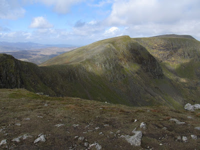
In the other direction, Helvellyn was firmly holding onto its top of cloud, but as I made my way down the ridge to the col overlooking Red Tarn and onto the craggy Swirral Edge, the clouds slowly began to lift. I know that the last time I did Striding Edge was in 2006 and that I have done Swirral Edge since then, but I can’t remember when I last did it; it was possibly January 2009. I had planned to do Striding Edge, on the other side of Red Tarn, the day before this walk, but poor weather had prevented that and now I would have to wait till some other time in the future to traverse that narrow ridge again. Instead I tackled the fun scramble on Swirral Edge, which is possibly more intense, more sustained than on Striding Edge, though I could be wrong due to my distant memory of that ridge that certainly does have more exposure. The scrambling on Swirral Edge is more prolonged as I climbed the satisfyingly steep ridge all the way up to the top of Helvellyn and by the time I reached the top the cloud had thankfully cleared allowing me to look back down the edge to Catstye Cam and the sunlit hills beyond.

Helvellyn is famous for being a tremendously popular mountain, but due to the early hour I had the top all to myself. Crossing the summit plateau and the deserted shelter I had fabulous, though misty, views towards the heart of the Lake District where a clear greening of the fells could be seen in the spring warmth that would soon prove short-lived due to the lack of rain and hot weather this summer. I didn’t stay on the main footpath but came off to climb up to the top of Nethermost Pike and keeping to the top of the ridge I passed over High Crag and up to the top of Dollywagon Pike, which was my fourth High Fell of the day and the fortieth of my holiday. I had set myself the target of reaching the summit of as many of the High Fells, that is the fells more than two and a half thousand feet high, as possible, and it was astonishing how many I had already done. There are fabulous views from Dollywagon Pike with most of my attention going to the ridge I had just come down where High Crag looked like a real mountain despite being merely a prominent shoulder of Nethermost Pike.

From Dollywagon Pike a very steep descent took me down a large series of zigzags in increasingly warm weather with the sun now shining brightly and promising a really great day in the Lakes. It felt really warm as I made my way around Grisedale Tarn and up to the top of Grisedale Hause where I turned left to head up the screes towards Fairfield. As I climbed the steep, slippery stones clouds came over once again and a cold wind began to blow so the woolly hat and gloves that had been a frequent feature of this holiday were back on. I don’t have fond memories of these screes ever since I first climbed them in 2002, however some work has been done to relieve the misery with good well-graded zigzags, but the path soon became sketchy and oppressively steep so by the time I reached the windswept summit of Fairfield I was very tired, as well as cold, though relieved to be at the top. Eating my lunch sheltered from the bitterly cold winds near the summit, I was reminded of the cold weather I had encountered during the first week of my holiday while the warm weather of the Bank Holiday weekend was now almost forgotten.

Slowly I made my way across the wonderfully craggy ridge above Rydal Head down to Link Hause and up to the top of Hart Crag through fabulous rock-covered terrain that is a pleasure to walk through and produces a great feeling of being at the top of a proper mountain. I had come to the Lake District to climb the High Fells specifically to find craggy terrain such as this and the cold weather was totally failing to dampen my enthusiasm. Continuing on I made my way across the gap to Dove Crag, which was now my seventh High Fell of the day beating my previous record on this holiday set on my first day and I still had another High Fell to go, though that was quite a distance away. Coming off the ridge of the Fairfield Horseshoe, and thankfully out of the cold wind, I made my way along a poor, muddy, eroded path down the hillside past Little Hart Crag to the Scandale Pass. Two years ago I had also made my way from Dove Crag to this point, but on that occasion I took the path past the High Bakestones cairn, so this time I took the more popular, more direct path, though I can’t say it is better. In 2016 I descended from Little Hart Crag, but now I climbed the long, tiring slopes all the way up to Red Screes, my forty-first High Fell of this holiday, before making my way along the ridge of Smallthwaite Band towards the stunning view that can be seen from Middle Dodd towards Brothers Water nestling in the valley between the fells of Hartsop Dodd and Hartsop above How.

My route lay ahead, but the way down the ridge from Middle Dodd is ridiculously steep and I was fortunate that my right knee was not hurting as much as it had earlier in the week, but neither of my knees appreciated this descent. Upon reaching the bottom I still had a long walk ahead of me along the valley passing Brothers Water to eventually reach the Patterdale Youth Hostel. This was a fabulous walk even though it was cold on the Fairfield Horseshoe and fairly cloudy for much of the day, but there was enough sunshine through the breaks in the cloud and I had some glorious views. It was great striding out along the great ridges of the Eastern Fells and being able to enjoy the views while walking on fantastic footpaths. Red Screes was a bit annoying as it felt like an add-on to the walk that was climbed simply because it was a High Fell. The walk would have been better if I hadn’t climbed the steep slopes from Scandale Pass, though I was rewarded with fabulous views down the valley. This was another glorious day in the Lake District.

Thursday 2 August 2018

Great Dodd and Raise

Wednesday 9th May 2018

After a good night’s sleep in the Skiddaw House Hostel and a chance to rest my knee that had been hurting for the previous couple of days, I left the fabulous “Loneliest house in England” and came all the way down off the hills into the village of Threlkeld. The weather was quite lousy with grey, overcast skies that would not improve, but rather worsened during the course of the day becoming windier and eventually ending in rain. This was not the best weather for walking in the Lake District, however at least it would feel like a walk in the Lake District with typical Lake District weather. Despite the inclement conditions I actually enjoyed being out on the fells in the harsh weather. The start of the day was not too bad as I slowly made my way down the track into Threlkeld, hastily across the scarily busy A66 trunk road and up the quiet road to the open fell. I remember when I came up this way in 2015 I followed a faint path beyond a fence, but this time I didn’t cross the fence as I took a fainter path up the hillside until it disappears in a marsh. Although crossing the fence is clearly the better route of the two, the latest Ordnance Survey maps show a path climbing the fell far from the fence aiming directly for Hause Well spring, but I don't if there is any trace of this route on the ground.

On reaching the Old Coach Road I found that it is in a very poor state having been heavily eroded by the heavy rains of the last couple of years. I can’t remember what state this track was in when I came this way in 2015, but of course, that would have been before the notorious storms of December 2015. On that occasion I had planned on climbing Great Dodd from the east, but chose to ascend from the north because I was tired. With no such problem now, and because I didn’t want to repeat my earlier route, I continued along the Old Coach Road until I reached Mariel Bridge where I turned off to climb steep, grassy slopes towards Randerside and Great Dodd. This was not an enjoyable climb as I toiled up a long, unrelenting and utterly featureless slope with thick, tussocky grass underfoot making for slow progress as strong winds persistently blew straight into my face under miserable, leaden skies. After mile after mile of slow, soul-destroying climbing towards a peak that I had identified as Randerside, though I never seemed to get any closer, eventually I reached the outcrop only to find that it was not Randerside, which was further ahead at the top of the north-east ridge coming down from Great Dodd.

The views from Randerside are severely restricted by the huge bulk of Great Dodd and the further swelling of Clough Head on the other side of Mosedale, though it was the grey, overcast skies that really marred the views. Turning my attention to the parent fell I set off along the clear path from Randerside that leads all the way up into the dark recesses of Great Dodd. Surprisingly the top was not covered in cloud and I had clear views towards Skiddaw, across Keswick and south along the ridge towards Helvellyn. The weather always seems to be poor when I am on Great Dodd, so the low cloud and strong winds that I was now encountering seemed almost reassuringly familiar, however the clear views were unusual even though there must have been occasions in the past when I had also had a view. Sheltering from the strong winds I had my lunch before wrapping myself up tight against the cold winds and setting off down the grassy slopes thoroughly enjoying the snug feeling while all around me was blowing a gale. Making my way along the broad ridge I came to the top of Watson’s Dodd where I had another good view towards Skiddaw and Keswick, however now I could see rain falling onto the town and before I had a chance to put on all my waterproofs the rain was falling on me too.

Setting off once more along the path I climbed into the clouds that covered Stybarrow Dodd eventually veering off in order to bag the summit. Returning to the path I headed over the lower summit and down the slopes towards the Sticks Pass descending below the clouds once more to reveal surprising views that lead all the way down to Ullswater. Despite the bad weather I kept going along the path over the pass and up the steep slopes that led me up to the delightfully craggy summit of Raise. After the grassy mounds of the three Dodds, it was great to be at the top of a fell with a proper mountainous feel to it. Coming down and crossing the col I made my way up the slopes to reach the low cairn and shelter that marks the top of White Side, and after circling the summit I headed back down to the saddle. The next High Fell on my schedule was Helvellyn, but I decided that in view of the poor weather it would be better to leave that for the next day, so after returning to the col I took the branch that begins the descent of the Pony Track and leads gracefully all the way down into Glenridding.

The weather may not have been the best for this walk, but aside from a lot of wind it had not been too bad with surprisingly good views from the summits until the rain started. There is something curiously satisfying about being at the top of High Fells in harsh weather, as you brave out the elements that you would not get if the weather was good. It made me feel like a real man who has truly conquered the mountain and beaten the elements, even though all it had really taken was a bit of blind determination to keep going. Since I was prepared with good waterproofs and warm clothing I was able to keep fellwalking even when the weather turned. The skies may have been dark and overcast with strong winds that ultimately brought rain, but I had fun.