Continuing the Challenge Walk around Charnwood Forest, from the top of Bardon Hill I returned to the radio mast and walked down the service road taking a footpath on the left when I reached the wide dirt track to walking between the wood and the desolation at the end of the dirt track. These quarries are not like the remains of tiny quarries that one sees in the Lake District or the Peak District as these are modern quarries: huge, horrible places that have made a right mess of the landscape, and are quite depressing. Emerging from the footpath on the edge of Coalville I walked up the hill to a T-junction where I crossed over to an area of rough country marked on the map as the Warren Hills, and is part of the Charnwood Lodge estate. The walk across this small area of unspoilt ground was quite a revelation. I had never been there before, in fact I didn't even know it existed. There were many outcrops dotted around the area and I had an immense desire to climb all over them, but that would have to wait for another day (like Boxing Day when I returned to the area for a play!). Emerging from the open country I walked a short distance along the road before turning left onto a narrow lane that eventually led me to Mount St. Bernard Abbey, which is the half way point of the walk and a convenient place to stop and have my lunch.
After a good rest I started stage three of the walk, which is probably the least interesting stage and also the point where the miles started to take their toil. Emerging from the Abbey driveway I took a footpath opposite down to the picturesque Blackbrook Reservoir and along a track to a road. Now began a prolonged spell of road walking punctuated by short spells across fields, as I walked to a crossroads and decided to go straight across instead of the prescribed turning right that would take me up the hill to the village of Oaks in Charnwood. This diversion seemed pointless as I would then have to come back down the hill again to this same road, so staying on the road saved me a lot of energy just at a point when I felt I had none left. Soon I turned into Lubcloud Farm and climbed over the hill down to a road (the B591) and passed under the M1. Another long stretch of road walking saw me go down a hill and up again as I climbed towards Beacon Hill.
 At the Rippin Memorial Walk near Beacon Hill I turned left onto a pretty avenue of trees as I wearily climbed up the hill to the top of Beacon Hill (at 248m), which is a fantastic place that I have visited many times in recent years, but now I was so weary I just found a chair and collapsed into it, and ate something to get my strength back. Eventually I felt refreshed and able to resume the walk down the hill through the woodland to the lower car park where I diverted from the prescribed route which would have required another walk along the road and instead I walked through the park straight to the Broombriggs car park. The prescribed route bypasses the top of Windmill Hill but with most of my strength back after the rest I rushed off up the hill to the remains of a windmill that gives the hill its name. Heading steeply down the hill I walked into the village of Woodhouse Eaves where I found my first shop in 18 miles which was able to resupply me with liquid refreshment. The onward route passed close to the local school and onto fields where I believe I made another mistake. The directions told me to turn right through a gate by the school but I must have gone straight on, however I didn’t realise my mistake for a while.
I still emerged onto a road as I was supposed to, but there was no path directly opposite, however there was one a short distance away so I took this as it seemed to be heading directly for Rushey Field Farm. However, this should have told me something was wrong as the path I should have been on passes to the north of the large farm. When I found a junction of paths I was puzzled as the Leicestershire Round that I thought I was on was actually crossing my path. My compass also failed to tell me what I had done wrong because I still hadn’t realised that I had earlier gone wrong. Eventually I decided to turn right as required but since I had approached on the wrong path I was now in fact taking the path I should have taken from Woodhouse Eaves. When I reached a lane, the same lane I had crossed earlier, now sporting a footpath directly opposite I realised my mistake.
I could have turned back and returned to the junction of paths but I really couldn’t be bothered. I was tired, I was near the end of the walk and it was starting to rain heavily. After walking along the road past the Brand I took the second turning on the right and soon entered Swithland Wood to walk back to my car in the pouring rain. At least I made it back to the car with plenty of daylight remaining, which was one consolation from the walk, as walking on the shortest day of the year may have made things rather difficult if I hadn’t kept up a quick pace. This was obviously a challenging walk that really tested my stamina in the latter stages, however I don’t think it was really that difficult apart from the distance and in better weather it may have been quite fun. Maybe I should repeat the walk in the spring, for now I’m just glad I managed to get around it.
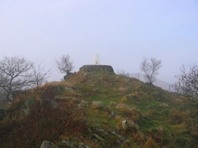 At the top of the hill is a big radio transmitter, and a short walk along the summit ridge brought me to the trig point, and not far from that is a huge fence while beyond the fence, barely discernible in the mist, is the huge Bardon Quarry. Bardon Hill may be the highest point in Leicestershire (at 278m) but Old John and Beacon Hill (seen later) are much more satisfying hills and they have not been exploited. More in my next post...
 From there I proceeded up the farm track opposite (and I only had to climb over two gates!) up onto the flanks of Little Wyvis. I didn’t go to the top which is a pity because it would have given me a purpose to the route that I had taken. When I eventually ran out of track I found myself at the top of a cliff with a wide boggy morass at the bottom where I had thought to walk. Coming to my senses I retraced my steps to the western slopes of the hill and began a precarious descent to the valley bottom and eventually I reached the bottom wetter and muddier than I had been. Immediately I started to climb the good path on the other side all the way up to the southern end of the enormous Ben Wyvis ridge, on An Cabar. Time was advancing so I quickly headed off to the summit of Ben Wyvis, Glas Leathad Mòr, and finally I reached the trig point at two o’clock. My train back to Inverness was due at 16.42, but a long way from where I was crouching in the shelter against a bitterly cold, gale force wind, and so with heavy raindrops falling I rushed off the ridge.
  When I finally reached Inverness I headed straight for a bookshop I remembered from previous visits for a browse of their enormous collection. Later, after a look around the rest of Inverness I tried to find a supermarket, eventually finding Safeway (now known as Morrison's) behind the station, and bought my dinner and lunch for the next two days. When I tried to find the hostel I had a few difficulties because although I knew the general area I didn't know precisely where it was. After over half an hour's wandering I asked at a newsagents and was told that I’d almost walked straight past it as it’s close to Safeway! Once finally at the hostel I had a shower and a lovely dinner before heading back out again into the city centre for a wander around the lovely city of Inverness. When I tried to get back to the hostel I had a familiar problem: I couldn’t find it! Retracing my steps I suddenly remembered that it was on Victoria Drive, which is a rather vital piece of information. The next day I was planning on catching a train to Garve and try to walk up Ben Wyvis. If the good weather I was enjoying since I left the West Highlands continues I hoped I will have no problems, we’ll see.
 Back to this walk, I headed into Fort William and caught a bus to Fort Augustus, where, after buying lunch, I headed off along the Great Glen Way beside Loch Ness. The weather had improved enormously now that I was away from the mountains of the West Highlands as it was now hot and sunny and I was wearing sunglasses and a wide-brimmed hat, with loads of sun cream. I had my lunch overlooking Loch Ness and it was just as I remembered from when I was last in the area in 2000: an eerie looking loch with hidden secrets under its surface. No one would call it a beautiful loch, like Loch Lomond, but it does attract your attention. Going further along the trail I descended into the small, picturesque village of Invermoriston before ascending the steep hill opposite and continuing along the trail to the Loch Ness Youth Hostel at Alltsigh.
 Back down I visited the Glen Nevis Visitor Centre again before heading back to the hostel where I considered what to do for the rest of the holiday. The weather forecast for this walk was for a good start but deteriorating later (it was still raining when I wrote the first draft of this entry in the hostel later in the afternoon, and it actually started raining while I was on the summit). The forecast for the next day looked like it may clear as the day progressed, so an idea occurred to me to do a walk in the hills to the south of Glen Nevis, in the Mamores, before heading to Fort William and catching a bus to Loch Ness. Certainly the Great Glen Way didn't appeal to me, which is what doing the West Highland Way had taught me. I have been up Ben Nevis again since this report was originally written (the picture above was taken on that return trip, in much better weather) and I have to say that I enjoyed the ascent much more the second time as I went up via the CMD arête. The report on that trip is


 I didn’t need to go to Inverarnan as it is off the route by almost a mile, but it was lunch time and I had plenty of time so I walked to the Drover's Inn and had a ‘Toastie’ and orange juice. I wasted almost an hour by this diversion and all I succeeded in doing was bringing me back to schedule. The remaining seven miles to Crianlarich was along a good path past rapids and waterfalls until I passed under the railway line and road, and climbed up the side of the valley on an old military road. I don’t know if it is a deliberate gesture by the Scots against a symbol of English domination, but the track was covered with animal mess, which made this one of the trickiest sections of the day as I tried to avoid the muck, which was occasionally unavoidable. Eventually I reached a crossroads where the trail turns left and I went right steeply down into Crianlarich where there is a good hostel even though was full of foreigners. Still, Crianlarich is a good village that I had been to before due to the locality of a railway station. The next day was going to be an easy walk to Bridge of Orchy and the railway would be with me the whole way.

 The descent down to Balmaha was easy, and it had taken me less than seven hours to do the whole nineteen miles. It was a good, enjoyable walk, so what was wrong with it? Well, at the end of the walk is a visitor centre wherein I managed to lose my maps. An extensive search failed to locate the missing maps so I had to buy replacements. It was fortunate that they had them there, but it was a huge expense that I hadn’t anticipated. And then there was where I stayed: Bunkhouse Lodge. I didn’t really know what to expect so I was surprised to find a room all to myself, although admittedly it wasn’t very big! My next cockup was with some cans I had bought from the local shop for dinner only to find out that there no kitchen facilities are provided in the bunkhouse. Oops! Instead I had to have something to eat in the nearby pub, which was much more expense, and since the bunkhouse did provide breakfast and packed lunches there was even more expense. Therefore I had already spent £37 from the £50 that I had taken out of the bank in the morning. I supposed that the cans would do for the next day and for now I had just treated myself to eating-out, so it’s just a pity that I hadn’t planned it that way.