Tuesday 4th June 2024
I was awoken at the start of this day by the realisation that my tent had collapsed due to the strong winds, a pole had snapped, which was not a great way to start the day. I lay there for a while dejectedly thinking about how this holiday had not gone to plan until eventually I got up and slowly removed everything from my tent. Fortunately I was not planning on camping for the rest of the holiday so I didn’t need to worry about repairing it. After eating my breakfast I took the opportunity to explore Achmelvich Beach once again, which I had been doing every evening since getting there and I never tired of the complex, craggy scenery and the sandy beach. The previous evening I had set off along the coast along a waymarked path that took me over Gleannan an Fheadair and past Alltan’ abradhan until I reached an old corn mill in a deserted little valley. An information board described how this used to work though there was little now to see of the mill. A small bay, Port Alltan na Bradhan, lay nearby but as it was getting late I soon turned around and headed back to the campsite. This is a fabulous area that I previously visited in 2010 so I enjoyed the opportunity to return even though the weather was not kind to me, just as in 2010, with strong winds that felt bitterly cold for the time of year and robbed me of my enthusiasm for climbing mountains. The forecast for this day was even for snow at the tops of the high mountains so I had to look for low level walks on what was sadly my last day in the historic county of Sutherland.

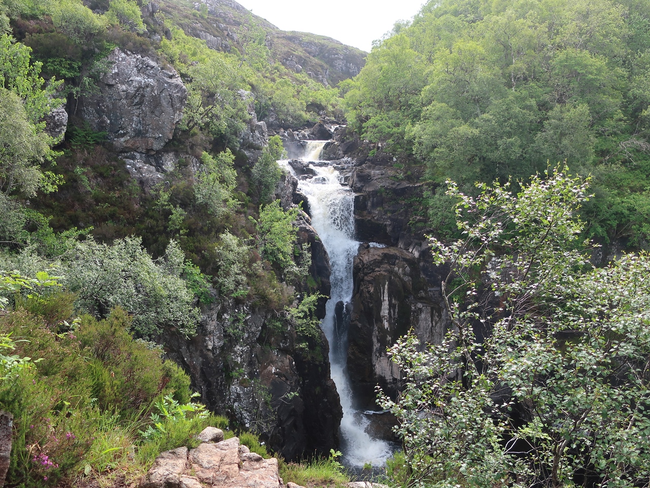
When I finally left Achmelvich Beach, I passed through Lochinver and along the narrow, single-track road through Strathan past Inverkirkaig to a small car park on the southern edge of Sutherland where a path follows the northern bank of the River Kirkaig. This was a great route which helped to calm my troubled mind and afforded me with good views into the deep recesses of the valley where the river was soon enclosed by woodland. The pleasant walk kept me high above the valley while mountains began to appear on the horizon, from my right were Stac Pollaidh, Cùl Beag, Cùl Mor round to Suilven on my left. They were all clear of cloud for the first time in several days which made me feel that an ascent of one of them must be possible if not for the strong, cold wind. At a cairn, I ignored the fainter path that heads towards Suilven and took the clear path that brought me steeply down to the river and soon provided me with views of the Falls of Kirkaig, which looked magnificent even before the descending steeply while the sun came out at just the right time to illuminate the spectacle. At the bottom of the precipitous path the full length of the falls revealed themselves and I was able to bask in the amazing sight until eventually I tore myself away and climbed back up the treacherously steep path and along the same route I’d taken out.
After my difficult start to the day, this walk did much to revive me, but it had only occupied a couple of hours and any thought of climbing a mountain was wiped out by the rain that welcomed me back to my car and followed me as I drove through Lochinver and out along the main road. I eventually stopped at the car park for the Bone Caves of Inchnadamph where it was still raining so I had an early lunch before donning my waterproofs and setting off towards the caves. However, the rain stopped almost immediately to reveal gorgeous sunshine on a wonderful walk past a small waterfall and up to Fuaran Allt nan Uamh where the water for the river seemed to bubble out of the ground as if by magic and the bed of the stream further up the valley was dry: I was in limestone country. I followed the path across the stream and steeply up the bank to reach the caves where the bones of arctic fox, lynx and wolf have previously been found. I had a fascinating time exploring the various caves and gazing out of them until eventually I continued along the path that crosses the steep slopes below Creag nan Uamh before reaching a stream and descending to the dry river bed of the Allt nan Uamh where I slowly made my way back down to the car park. Inevitably it started to rain when I reached my car but I really enjoyed this short walk up to the bone caves which was helped by the timely appearance of the sun.

The rain was heavy but brief and with the skies clearing again I looked longingly on the surrounding mountains. At one time I had planned to climb Canisp on this holiday which is a mountain that lies west of the bone caves and I looked eagerly at it now. Despite knowing that Canisp is a big mountain and an ascent would take me a long time, I could not resist setting off along a boggy path that would take me towards the broad eastern slopes, but impenetrable bogs convinced me of the foolishness of my endeavour and soon I turned back. While driving towards Ullapool I was frustrated at the sight of fabulous mountains that I couldn’t climb but when I reached the Knockan Crag National Nature Reserve I pulled into the car park. I hadn’t planned on walking around this reserve, partly because it isn’t in Sutherland, it is just across the border, but also because I visited Knockan Crag in 2010. This area played a significant role in the development of our understanding of geology, but that wasn’t what motivated me to stop. I just wanted to do a walk and if I couldn’t climb a mountain then I would try to get a view of them instead. The awesome Cùl Mor was nearby while its lesser partner, Cùl Beag could also be seen, however it wasn’t long before a heavy shower overwhelmed me so I crouched behind the northern viewpoint and waited while hail and rain fell.

When it eventually began to ease I got up and headed into the rain along the path that runs along the top of the crag and by the time I returned to the car park it had stopped raining and the sun was out again. This day was a hotchpot of different walks that sadly ended my time in Sutherland. I was astounded by the sight of the tremendous mountains in the historic county but frustrated that I was unable to climb any of them. Instead I was forced to do small walks that I would otherwise never have done and surprisingly I found that I really enjoyed them.


 Eventually, after a lot of effort, I managed to reach the rocks at the top of Sgòr Chaonasaid. It was very windy up there, but nevertheless I clambered onto the top of the end crag from where I had great views along the length of the Kyle of Tongue and behind to the summit of Ben Loyal across a grassy plain. Climbing back down I bypassed all the other rocky tops, the most notable being the second top, Sgòr a’ Bhatain, and headed straight for the summit of Ben Loyal, An Caisteal (The Castle). The summit is well named as it is a huge circle of rock, impregnable except at one point, surrounded by the towers of the other tops of Ben Loyal. After climbing onto the huge rock that is the summit I found the trig point that marks the summit of the Corbett (Ben Loyal is not a Munro as it is less than three thousand feet high, in fact it almost isn’t a Corbett as it is only just above two and a half thousand feet). Climbing back down and circling round to the south I found shelter from the wind and had my lunch.
 I parked alongside other cars at the foot of the main path up Ben Hope and followed others up the path beside a stream. When I had started it looked like the good weather was back so I was slapping on sun cream and stripping down, but unfortunately it didn’t last. When the walkers ahead of me left the stream behind I stayed beside it and climbed a shelf below the high western cliffs of Ben Hope. Unfortunately I carried on climbing when I should have stayed beside the stream so by the time the stream reached Dubh-loch na Beinne I was high above the lake on a steep hillside. My difficulty in continuing to walk along that steep gradient eventually prompted me to try and climb onto the top of the ridge. After a lot of very steep climbing I eventually reached the top of the ridge where I collapsed onto the ground and had my lunch, while rain started to fall. The point where I’d joined the ridge was at about the 700 metre contour so I was already a good way up the ridge having missed out on the delights lower down.
  Resuming the walk I climbed up the ridge through clouds to the foot of a bad step where I suddenly had stunning views below the clouds of a small loch in a corrie and Loch na Seilg beyond. The bad step is a serious scramble and far beyond my capabilities so I simply side-stepped it by climbing up a nearby gully, which was rather difficult itself in the wet weather, though not unenjoyable. Ultimately I reached the top of the crag face where a short walk brought me to the summit. Ben Hope should have stunning views as there are no other Munros for miles around, but the top was covered in clouds, which spoiled my view. On my descent, once I was below the clouds I was still sufficiently high enough to have some quite good views up the deserted Strath More. My descent was a straightforward walk along the regular, tourist route down a steep, wide, stony hillside and a muddy path back down to the road.
 Ralph Storer recommends traversing the south ridge of Ben More Assynt, but this is an exposed, hard scramble that I didn't want to do in this weather (or indeed any weather!), so I turned around and retraced my steps. If Ben More Assynt had been a sandstone mountain then that difficult, narrow south ridge would have had an easier, bypassing route around the side. The Lewissian Gneiss of that ridge is some of the oldest rock in the world, so it isn’t easily eroded into paths and would be tricky to traverse, even in good weather. As I descended from Ben More Assynt the clouds unexpectedly started to part, revealing views of Dubh Loch Mór to my right and the wide waterlogged valley of Garbh Allt to my left. With a clear view of the ridge in front of me I bounced across and joyously climbed back up to the top of Conival, the third Munro that I had climbed up that day (also my first Munro of the day), and I was still in clouds.
  Returning to the saddle I climbed along the eastern ridge as far as I could go, though I only actually reached the first col. I could have gone further but I didn't want to. Like many of the mountains that I had encountered on this holiday, Suilven is a Torridonian Sandstone mountain with ridiculously steep sides and rock pinnacles on top. The eastern end of the mountain requires some rock climbing that I just wasn’t in favour of trying. These Torridon-esque mountains may be stunning to look at, but they terrified me. I never thought I had vertigo until this holiday. Fortunately, unlike Stac Pollaidh
  After returning to Bealach Mor I reluctantly started to descend the steep hillside back down to the loch-scattered moor at the bottom. All that was now left for me to do was to walk slowly back down the valley in the warm weather past inviting lakes and moorland flowers in a plenty, with the might of Suilven itself behind me basking in the sunlight, like the prow of a battleship. This was a wonderful walk not just because of the fantastic mountain in the middle of the walk, but for the relaxing stroll through a picturesque valley where the view of Suilven dominates the scene. For any other walk the necessity of having a long walk in to the mountain would detract from the experience, but on this occasion and in this weather it adds to it. The path is a well-made stalkers' track that is always dry and passes through a valley that was a delightful place to walk through and always with the view of Suilven enticied me forward with every step. Back at Achmelvich Beach Youth Hostel the weather was great and the views across the bay were idyllic. This is such a wonderful area I was so gutted to be only staying there for two nights rather than my originally intended four nights. I spent that evening on the rocks overlooking the bay while reading a book and taking pictures of the stunning surroundings. My holiday would not get any better than this.