Thursday 17 August 2023

Southern Upland Way: The Roman Road

Wednesday 31st May 2023

By this point in my holiday I felt like I had been on the Southern Upland Way for many days and yet I still had several more to go, so with the feeling of monotonous repetition I set off again on the trail. I had spent the night in a guest house in Galashiels, so first I had to make my way through the town and back to the point where I had left the Southern Upland Way the day before onto a winding course that took me through the outskirts of Galashiels before climbing around the side of Gala Hill. At the bottom of the hill I came to the River Tweed where I turned left and followed it under Galafoot Bridge and up to a road beside the Gala Water. This road took me to the railway line, where I assume previously the trail used to turn onto the old trackbed, but then in 2015 the line was reinstated so now my path ran alongside the railway, over the River Tweed and into Tweedbank railway station. Originally the line passed all the way through the Scottish Borders to Carlisle, but Tweedbank is currently the terminus so after passing the station I continued along the route of the old railway line before turning back down to the River Tweed which I now followed past Waverley Castle Hotel until I reached Gattonside Suspension Bridge.


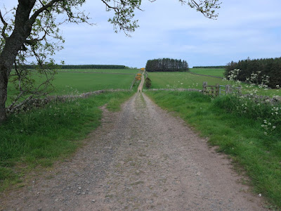
For most of this holiday I had been enjoying sunshine everyday but now it was dull and grey, which didn’t help my mood as I was feeling very tired after a poor night’s sleep. I had a rest beside the chain bridge before crossing over the river and back along the other side until I had almost reached Waverley Castle Hotel again. This side of the river was beautifully decorated with wild flowers, which picked up my spirits a little but soon I moved away from the river and onto a track that climbed out of the valley and through dull farmland that matched the dull skies. The undulating path crossed the western slopes above Blake Burn before finally joining a clear track that climbs away from the burn and now provided me with an arrow straight route across tedious landscape. At times the track was lined with gorse, which provided me with some interest, and eventually the sun began to slowly break through the heavy clouds. This track is so straight it is easy to imagine that originally it was a Roman Road and some say it is part of Dere Street which ran from York into Scotland, though its origins may lie elsewhere. The website for the Southern Upland Way gives approximate locations of hidden hoards of treasure along the trail and names one as “Melrose and the Roman Road”, so while on this track I kept my eyes peeled for the sculptured kist that marks the location of the hoard.


Unfortunately I didn’t find it, however I did find an odd object that at the time I didn’t understand but now I think may have been the kist, though I don’t know how you get inside to the coins or why I didn’t realise it was the kist. Perhaps I was so tired I just wasn’t thinking clearly. The one point of interest while on the Roman Road was later when I was diverted around a farm building into woodland with tall, thick grass underneath, but this was very brief and soon I was back on the wide track. Not long after that I started to descend towards the valley of the Lauder Burn, but the path merely skirted the edge of the valley around a golf course before descending into the town of Lauder. There didn’t seem to be much going on in the town so I returned to the trail and entered the grounds of Thirlestane Castle on excellent paths that took me across Lauderdale and up through the woodland. I was feeling very weary by this point in the day and was full of aches and pains as I very slowly dragged myself up the hill and down to the Snawdon Water and then up over a hill that was covered in daisies. Finally, I descended to the Blythe Water where the rambling man website says is the best wild camping spot on the Southern Upland Way and I really needed a good rest after this dreary walk.


This was a delightful spot, especially as it was now sunny and I was able to lie on the short grass beside my tent, bask in the sunshine and recover from the exhausting day. There was nothing in the actual walk that was strenuous but it still seemed to wipe me out. It left me feeling so depressed I had to remind myself that this was not a bad holiday even though the Scottish Borders were not exciting me like the earlier section in Dumfries and Galloway which had provided me with some great walking that made me to want to return. I was finding the Scottish Borders very disappointing, especially on this walk, which was very dull and I was so tired I wasn’t able to ignore that. This was a low point on my holiday. My legs were aching and I had blisters on my feet even though up to this day my boots had performed brilliantly. There is a lot of variety to the Southern Upland Way so with the highs there are some definite lows and this day was my lowest point.

Thursday 10 August 2023

Southern Upland Way: Minch Moor

Tuesday 30th May 2023

I woke at the start of this day to clear skies again, which was almost beginning to get tiresome (!). I suppose I shouldn’t complain but I seemed to be getting wall to wall sunshine every day on this holiday, which you just don’t expect in Scotland. I had camped on the edge of Craig Douglas Forest and after breaking camp I left the conifer plantation to head across the broad, open grassy hills of Blake Muir on the eastern half of the Manor Hills. During the course of the Southern Upland Way I had been finding hidden hoards of treasure added by the ranger service to encourage people to walk the trail and it was certainly adding interest to my walk. A map at the start and on the website indicates, roughly, where they are hidden and that shows that a hoard, marked by a sculptured kist, should be in this area, but I could not find any sign of it. Usually, the word “ultreia” on a trail post will warn you to look out for the kist as it is just ahead, but I never came across the word or the kist while climbing up through Craig Douglas Forest the previous day or now while traversing Blake Muir. So, frustratingly, I had missed another one adding to the previous two that I had missed despite finding the word “ultreia” on those occasions, but not the kist. At the bottom of the hill I came across a road and followed that for some hair-raising moments, especially when coming round blind corners, until I thankfully reached the small village of Traquair.


Nearby is Tranquair House, the oldest inhabited house in Scotland and just beyond that is the town of Innerleithan, which had been in my view during the descent and has shops and places to stay, but I wasn’t in need of its services, so when I reached the crossroads in the centre of Traquair I turned right to head up to Minch Moor. The path seemed very popular and apparently has been well-used for hundreds of years as I was now on the Cross Borders Drove Road, which is a long distance trail that follows the tracks previously used by drovers who used to drive cattle from the markets in Scotland southwards for sale in England. This was a tiring climb under the blazing sun as I climbed through a sparse conifer plantation that was providing me with only partial shade and soon I emerged onto the heather covered Minch Moor. When I eventually reached the junction for the path up to the trig point at the summit of Minch Moor I saw the word “ultreia” attached to the signpost. I was hopeful that this time I would not miss the kist so I kept my eyes peeled as I slowly made my way along the path and before too long I found the surreptitiously hidden kist. The coins inside were wrapped in small plastic bags, which is a good idea as some of the coins I have found in previous kists have been rusty, but these were in excellent condition and it made up for the coin that I had failed to find on Blake Muir.


My views north, across Tweeddale, were blocked by the Moorfoot Hills and Windlestraw Law, the highest point in the range, but the most extensive views were now south and east across the plains of the River Teviot with the Cheviot Hills in the hazy distance. A monotonously flat ridge led me on from Minch Moor and I wasn’t enthusiastic about the lack of hills in the far distance, but for now I was happy to enjoy the extensive views. I could see a couple of distinctive peaks, in my direction of travel, which were undoubtedly the Eildon Hills that look over the town of Melrose, but since they are not on the route of the Southern Upland Way all I could do was gaze upon them from afar. This moorland traverse may have been enlivened by doing the walk later in the year, in late summer, when the heather is in bloom, and I had originally planned to do the trail at that time, but I think I gained much more by walking in late spring when the woodland flowers, particularly bluebells, are in bloom, and besides, the heather wasn’t looking too bad and the bilberry was a vibrant green, which made up for it. By the time I reached Broomy Law the views north had opened up and were stunning, down the Glenkinnon Burn and then after crossing the River Tweed extends over the low hills west of Galashiels to Longpark Wind Farm.


While the extensive views continued to draw my eye, Yarrowdale to the south was now also distracting me, the conifer plantation of Yair Hill Forest came alongside to my left and I came up to the handsomely built cairns of the Three Brethren. At the col with Peat Law I turned left to descend through the conifers to the Shorthope Burn where deciduous trees took over and wild flowers decorated the path and provided me with a glorious promenade down to the mighty River Tweed. Once over the river, an excruciating climb through farmland took me over Hog Hill and once I had somehow dragged myself up the hill I slowly descended into the town of Galashiels. The paths through the woodland near Gala House seemed like a maze, but good signposts directed me through the many turns and brought me onto a road on the outskirts of the town. I hadn’t booked any accommodation in Galashiels beforehand so I was really lucky that I was able to find a spare bed at Monorene Guest House, thanks to a cancellation. This was an interesting walk, though my mind was often distracted by the uncertainty of where I was going to spend the night. The views from the ridge that starts on Minch Moor were exceptional, but the path beside Shorthope Burn, which was filled with wild flowers, was also a highlight as was the woodland path coming into Galashiels. However, as with so many times on this holiday, the weather and the clear blue skies set the whole day off and enabled those stunning views.

Thursday 3 August 2023

Southern Upland Way: St Mary’s Loch

Monday 29th May 2023


After a night at the Over Phawhope Bothy I set off along the upper Ettrick Valley for a long walk along the road. Despite the tedium, I had a very relaxing walk with hardly any changes in the gradient while the sun shone brightly overhead and the only traffic was a timber truck. After an hour and a half I came to a sign that proclaimed that I was finally turning off the road and up grassy slopes away from the cranesbill geraniums that were decorating the roadside at that point and up into the hills north of the Ettrick Valley. After an initial steep climb through the first field, a gentle ascent beside the Scabcleuch Burn took me up and over the pass across the eastern slopes of Peniestone Knowe. At the end of the ridge, Pikestone Rig, I descended steeply to the ruin of Riskinhope Hope where I stopped for lunch in this tranquil and isolated place before climbing again, beside Kye Sike and around Earl’s Hill. On reaching a forestry track I followed it out of the plantation and down the hill towards St Mary’s Loch where there were stunning views and across its neighbour, the Loch of the Lowes, which arguably has better surroundings as the Ettrick and Moffat Hills extend all the way down to the shores of the loch, though the northern shore was marred by a felled conifer plantation.


After the restricted views while climbing over the hills it was great to enjoy the surroundings beside the western end of St Mary’s Loch, so to prolong my stay I decided to get something to eat and drink in the Glen Café. The car park nearby was packed, with many people venturing out onto the loch on paddle boards or kayaks, and with some were just sitting out in the sun. I was happy for some shelter from the sun so I stayed inside the café and enjoyed a lovely cup of tea, something to eat and a rest. Eventually I set off past the tourists and through Tibbie Shiels Campsite to St Mary’s Loch where I found a wonderful footpath lined with tormentil and bugle which took me beside the loch and through delightful March Wood before entering denser woodland. Eventually the lovely path joined a tedious forestry track and this took me to the eastern end of the loch where I crossed the Yarrow Water and climbed past farmland into the Manor Hills. While the views at this end of St Mary’s Loch did not seem as dramatic as those at the other end, they still provided me with enjoyable walking across grassy hills with views down the Douglas Burn, which was decorated with gorse.


The path led me into the narrow dell of the Hawkshaw Cleuch, which was richly filled with trees, but short lived and soon I was back out onto a grassy hillside and slowly descending to the Douglas Burn. After crossing the river and passing some houses I entered Craig Douglas Forest, a conifer plantation, and began to climb up the hill while thinking about where I was going to stop for the night. A forestry track didn’t provide me with anywhere to stop as the ground was too stony so I continued to climb and eventually emerged from the plantation. Before me was a broad, open, grassy hillside with many sheep and nowhere to camp, so eventually I decided to turn around and put up my tent just into Craig Douglas Forest, beside the wall. This was a curious day as evidenced by this relatively short blog entry. When reflecting on the walk at the end of the day, I described it as perfunctory as there was little to interest me as I simply covered the miles, though the highlight was clearly St Mary’s Loch, which was a very popular area particularly beside the café. Other than the walk around St Mary’s Loch, the rest of the day was dull as I started to count down the days to the end of the walk.