Continuing the Challenge Walk around Charnwood Forest, from the top of Bardon Hill I returned to the radio mast and walked down the service road taking a footpath on the left when I reached the wide dirt track to walking between the wood and the desolation at the end of the dirt track. These quarries are not like the remains of tiny quarries that one sees in the Lake District or the Peak District as these are modern quarries: huge, horrible places that have made a right mess of the landscape, and are quite depressing. Emerging from the footpath on the edge of Coalville I walked up the hill to a T-junction where I crossed over to an area of rough country marked on the map as the Warren Hills, and is part of the Charnwood Lodge estate. The walk across this small area of unspoilt ground was quite a revelation. I had never been there before, in fact I didn't even know it existed. There were many outcrops dotted around the area and I had an immense desire to climb all over them, but that would have to wait for another day (like Boxing Day when I returned to the area for a play!). Emerging from the open country I walked a short distance along the road before turning left onto a narrow lane that eventually led me to Mount St. Bernard Abbey, which is the half way point of the walk and a convenient place to stop and have my lunch.
After a good rest I started stage three of the walk, which is probably the least interesting stage and also the point where the miles started to take their toil. Emerging from the Abbey driveway I took a footpath opposite down to the picturesque Blackbrook Reservoir and along a track to a road. Now began a prolonged spell of road walking punctuated by short spells across fields, as I walked to a crossroads and decided to go straight across instead of the prescribed turning right that would take me up the hill to the village of Oaks in Charnwood. This diversion seemed pointless as I would then have to come back down the hill again to this same road, so staying on the road saved me a lot of energy just at a point when I felt I had none left. Soon I turned into Lubcloud Farm and climbed over the hill down to a road (the B591) and passed under the M1. Another long stretch of road walking saw me go down a hill and up again as I climbed towards Beacon Hill.
 At the Rippin Memorial Walk near Beacon Hill I turned left onto a pretty avenue of trees as I wearily climbed up the hill to the top of Beacon Hill (at 248m), which is a fantastic place that I have visited many times in recent years, but now I was so weary I just found a chair and collapsed into it, and ate something to get my strength back. Eventually I felt refreshed and able to resume the walk down the hill through the woodland to the lower car park where I diverted from the prescribed route which would have required another walk along the road and instead I walked through the park straight to the Broombriggs car park. The prescribed route bypasses the top of Windmill Hill but with most of my strength back after the rest I rushed off up the hill to the remains of a windmill that gives the hill its name. Heading steeply down the hill I walked into the village of Woodhouse Eaves where I found my first shop in 18 miles which was able to resupply me with liquid refreshment. The onward route passed close to the local school and onto fields where I believe I made another mistake. The directions told me to turn right through a gate by the school but I must have gone straight on, however I didn’t realise my mistake for a while.
I still emerged onto a road as I was supposed to, but there was no path directly opposite, however there was one a short distance away so I took this as it seemed to be heading directly for Rushey Field Farm. However, this should have told me something was wrong as the path I should have been on passes to the north of the large farm. When I found a junction of paths I was puzzled as the Leicestershire Round that I thought I was on was actually crossing my path. My compass also failed to tell me what I had done wrong because I still hadn’t realised that I had earlier gone wrong. Eventually I decided to turn right as required but since I had approached on the wrong path I was now in fact taking the path I should have taken from Woodhouse Eaves. When I reached a lane, the same lane I had crossed earlier, now sporting a footpath directly opposite I realised my mistake.
I could have turned back and returned to the junction of paths but I really couldn’t be bothered. I was tired, I was near the end of the walk and it was starting to rain heavily. After walking along the road past the Brand I took the second turning on the right and soon entered Swithland Wood to walk back to my car in the pouring rain. At least I made it back to the car with plenty of daylight remaining, which was one consolation from the walk, as walking on the shortest day of the year may have made things rather difficult if I hadn’t kept up a quick pace. This was obviously a challenging walk that really tested my stamina in the latter stages, however I don’t think it was really that difficult apart from the distance and in better weather it may have been quite fun. Maybe I should repeat the walk in the spring, for now I’m just glad I managed to get around it.
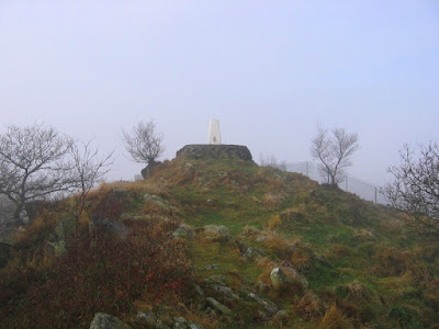 At the top of the hill is a big radio transmitter, and a short walk along the summit ridge brought me to the trig point, and not far from that is a huge fence while beyond the fence, barely discernible in the mist, is the huge Bardon Quarry. Bardon Hill may be the highest point in Leicestershire (at 278m) but Old John and Beacon Hill (seen later) are much more satisfying hills and they have not been exploited. More in my next post...
 From there I proceeded up the farm track opposite (and I only had to climb over two gates!) up onto the flanks of Little Wyvis. I didn’t go to the top which is a pity because it would have given me a purpose to the route that I had taken. When I eventually ran out of track I found myself at the top of a cliff with a wide boggy morass at the bottom where I had thought to walk. Coming to my senses I retraced my steps to the western slopes of the hill and began a precarious descent to the valley bottom and eventually I reached the bottom wetter and muddier than I had been. Immediately I started to climb the good path on the other side all the way up to the southern end of the enormous Ben Wyvis ridge, on An Cabar. Time was advancing so I quickly headed off to the summit of Ben Wyvis, Glas Leathad Mòr, and finally I reached the trig point at two o’clock. My train back to Inverness was due at 16.42, but a long way from where I was crouching in the shelter against a bitterly cold, gale force wind, and so with heavy raindrops falling I rushed off the ridge.
  When I finally reached Inverness I headed straight for a bookshop I remembered from previous visits for a browse of their enormous collection. Later, after a look around the rest of Inverness I tried to find a supermarket, eventually finding Safeway (now known as Morrison's) behind the station, and bought my dinner and lunch for the next two days. When I tried to find the hostel I had a few difficulties because although I knew the general area I didn't know precisely where it was. After over half an hour's wandering I asked at a newsagents and was told that I’d almost walked straight past it as it’s close to Safeway! Once finally at the hostel I had a shower and a lovely dinner before heading back out again into the city centre for a wander around the lovely city of Inverness. When I tried to get back to the hostel I had a familiar problem: I couldn’t find it! Retracing my steps I suddenly remembered that it was on Victoria Drive, which is a rather vital piece of information. The next day I was planning on catching a train to Garve and try to walk up Ben Wyvis. If the good weather I was enjoying since I left the West Highlands continues I hoped I will have no problems, we’ll see.
 Back to this walk, I headed into Fort William and caught a bus to Fort Augustus, where, after buying lunch, I headed off along the Great Glen Way beside Loch Ness. The weather had improved enormously now that I was away from the mountains of the West Highlands as it was now hot and sunny and I was wearing sunglasses and a wide-brimmed hat, with loads of sun cream. I had my lunch overlooking Loch Ness and it was just as I remembered from when I was last in the area in 2000: an eerie looking loch with hidden secrets under its surface. No one would call it a beautiful loch, like Loch Lomond, but it does attract your attention. Going further along the trail I descended into the small, picturesque village of Invermoriston before ascending the steep hill opposite and continuing along the trail to the Loch Ness Youth Hostel at Alltsigh.
 Back down I visited the Glen Nevis Visitor Centre again before heading back to the hostel where I considered what to do for the rest of the holiday. The weather forecast for this walk was for a good start but deteriorating later (it was still raining when I wrote the first draft of this entry in the hostel later in the afternoon, and it actually started raining while I was on the summit). The forecast for the next day looked like it may clear as the day progressed, so an idea occurred to me to do a walk in the hills to the south of Glen Nevis, in the Mamores, before heading to Fort William and catching a bus to Loch Ness. Certainly the Great Glen Way didn't appeal to me, which is what doing the West Highland Way had taught me. I have been up Ben Nevis again since this report was originally written (the picture above was taken on that return trip, in much better weather) and I have to say that I enjoyed the ascent much more the second time as I went up via the CMD arête. The report on that trip is


 I didn’t need to go to Inverarnan as it is off the route by almost a mile, but it was lunch time and I had plenty of time so I walked to the Drover's Inn and had a ‘Toastie’ and orange juice. I wasted almost an hour by this diversion and all I succeeded in doing was bringing me back to schedule. The remaining seven miles to Crianlarich was along a good path past rapids and waterfalls until I passed under the railway line and road, and climbed up the side of the valley on an old military road. I don’t know if it is a deliberate gesture by the Scots against a symbol of English domination, but the track was covered with animal mess, which made this one of the trickiest sections of the day as I tried to avoid the muck, which was occasionally unavoidable. Eventually I reached a crossroads where the trail turns left and I went right steeply down into Crianlarich where there is a good hostel even though was full of foreigners. Still, Crianlarich is a good village that I had been to before due to the locality of a railway station. The next day was going to be an easy walk to Bridge of Orchy and the railway would be with me the whole way.

 The descent down to Balmaha was easy, and it had taken me less than seven hours to do the whole nineteen miles. It was a good, enjoyable walk, so what was wrong with it? Well, at the end of the walk is a visitor centre wherein I managed to lose my maps. An extensive search failed to locate the missing maps so I had to buy replacements. It was fortunate that they had them there, but it was a huge expense that I hadn’t anticipated. And then there was where I stayed: Bunkhouse Lodge. I didn’t really know what to expect so I was surprised to find a room all to myself, although admittedly it wasn’t very big! My next cockup was with some cans I had bought from the local shop for dinner only to find out that there no kitchen facilities are provided in the bunkhouse. Oops! Instead I had to have something to eat in the nearby pub, which was much more expense, and since the bunkhouse did provide breakfast and packed lunches there was even more expense. Therefore I had already spent £37 from the £50 that I had taken out of the bank in the morning. I supposed that the cans would do for the next day and for now I had just treated myself to eating-out, so it’s just a pity that I hadn’t planned it that way.
 With reluctance I left the Major Oak and headed through the forest joining a bridlepath as it proceeded northwards and entered Budby South Forest. With hindsight I should have stayed within the country park, as instead I was passing an army training ground on an old track through a wilderness with few trees. I was fenced in and couldn’t really enjoy the open scenery, even though it was amazing to see such unspoilt country in Nottinghamshire of all places. On returning back to the edge of the forest I walked along a cycle way to Hazel Gap and there I followed the Robin Hood Way into Duncan Wood and along Freeboard Lane until I reached the A614. During this time the sun had come out, as promised, and revealed a lovely day to be out walking, but unfortunately it wouldn’t last. Heading north for a short distance I rejoined the Robin Hood Way and entered Clumber Park, a National Trust property that is apparently a popular tourist attraction (even though I'd never heard of it).
 Upon reaching Hall Dale the path improved and half way to Ilam Rock I left the valley bottom to climb steeply up the hillside. The route description I was following said that I would reach the Rock before climbing and the map seemed to agree, but that is maybe no longer the case as the path zigzagged steeply up the hillside on a manufactured path to the edge of the wood. There now followed an enjoyable walk just inside the wood high above the valley that all too soon ended at a gate that led me out of the wood. Again the map seemed to be incorrect as it claims the path descends steeply into the wood at this point, but instead the path maintained a level course below a farm track just above the tree line before swinging around Air Cottage and joining the farm track.
 Eventually the river widened and the valley opened out into Water-cum-Jolly Dale, a glorious place, before I reached Cressbrook Mill, which although a nicer place than Litton Mill has also been turned into luxury apartments. Beating a hasty retreat I climbed back up to the railway line that had been inaccessible as it passed through closed tunnels (they were opened in 2011). Continuing along the Monsal Trail I passed the site of Monsal Dale Station and over Monsal Viaduct, which is an iconic picture of the line. Beyond the viaduct I climbed up to Monsal Head and took a look at the panoramic views of the valley as it sweeps around the corner. Descending from Monsal Head I took a path through the wood down into Monsal Dale and across the river by a footbridge. All that now remained for me was to have a pleasing walk through Monsal Dale, which is wider than Miller’s Dale and not as thrilling but still enjoyable and took me back to my car. This walk shows that one doesn’t really need to go up a mountain to have a thoroughly enjoyable walk.
 After surveying my surroundings from the cairn at the top of the crag for a while, I headed off along the northern flanks of the fell. This was proving to be a fabulous walk as the path hugged the side of the bracken-covered fell gradually gaining height. I passed the ruins of an old shooting hut and turned west towards the summit crossing wetter ground until I reached the summit crag. Climbing atop this rocky outcrop I arrived at the trig point and the summit to tremendous views all around me, and despite the full car park no one else was there. With time progressing I missed out Wainwright's recommended descent over Green Hill and took a direct course down the fell to the river. I had a feeling that was where everyone else would be.

 Once at the summit I was amazed by the stunning views that I could see all around me of mountains in all directions except across Rannoch Moor. The best views were to the north encompassing some of the highest and best looking mountains in the country, especially those around Glen Coe and Glen Nevis. I was mesmerised and couldn't help thinking that this was my last mountain of the year. I went home the next day and I would not get to see views like this again till next year. I didn't want to leave, but eventually, and with great reluctance, I left the summit and descended the narrow ridge eastwards. This ridge is called Aonach Eagach and even though it is nowhere near as bad as it's Glen Coe namesake I was still rather nervous as I crossed the short narrow ridge. At a 991m top I decided that I would spurn Storer's route down the widening ridge of Aonach Eagach in favour of the clear footpath north to the bealach.
 Coming down from the Munro I walked along the ridge over the 902m top and up to Stob na Doire. At 1011 metres it really deserves to be a Munro and it certainly looks like one, but it has not been afforded that honour. As consolation I had lunch on the top before continuing my traverse of the ridge descending steeply to the lowest point on the ridge (at 825m) and then climbed once more up to the top of Stob Coire Altruim. This top justly does not deserve to be a Munro as with barely any descent I walked to the end of the ridge and the second Munro of Buachialle Etive Mór, Stob na Bròige. With the entire length of the mountain completed I doubled back on myself, minimizing re-ascent by traversing the grassy southern slopes of Stob Coire Altruim, until I reached the top of Coire Altruim where I took the path down into the corrie, steeply at first and later scrambling beside the cascading stream.

 Reaching the summit ridge I walked along what I'm sure would have been a delightful ridge in clear weather, but I was not so blessed. Eventually I arrived at the summit where there is a trig point, a shallow cairn and a little distance away was a metal cross marking a memorial to a mountain rescuer who was killed on Ben More. The conditions discouraged a prolonged stay so I left south-east along the ridge and descended over Meall Odhar and down below the clouds. Despite the rain stopping, the view, although extensive, was not great (perhaps it was just the poor light) as Ben Ledi lies near the Highland fault and everything I could see southwards was lowland, including a wind farm. The fabled Trossachs were shrouded in dark clouds and could not be seen clearly. Following the path, I turned left and dropped steeply down below Creag Gorm re-entering the forestry land and descended further beside the Corriechrombie burn plunging into the woodland back down to the road and my car. This was not a great walk, although it would have been helped by better weather, but it was too short to be really satisfying.
 Onward from Ben Vorlich I followed a path beside a line of rusting metal posts south-west off the mountain and down to Bealach an Dubh Choirein. In the patchy cloud I could see Stuc a'Chroin ahead of me with a big cliff barring my way. I was looking forward to the scramble up, so I was rather disappointed with the path that I was following as it went off to the left around the side of the cliff. Later, when I read Ralph Storer's account of a walk up these mountains, he describes a clear path scrambling up the cliff. Where has that gone? I almost feel cheated by the path that I followed as I would have enjoyed a scramble up that cliff-face. The path I did follow went up a wide gully behind the north top climbing steeply but easing the work through zigzags whenever possible. Once on top I walked south through the mist to the summit cairn where I had my lunch.
 Now began a fantastic traverse of this undulating and ever changing ridge. The clear path cunningly negotiated the many twists and turns and avoided unnecessary hilltops while steering a course for the successive prominent tops on the ridge. First on the list was probably the best, Meall Garbh, a tiny pinnacle-like summit that looked insurmountable from a distance. Beyond the summit was a narrow rocky ridge that was rather hairy in the strong wind, followed by a short scramble down a small cliff face. Next on the list was Beinn nan Eachan, which was tame in comparison, and that was followed by Creag na Caillich, but it wasn't the tops that was the appeal of this walk as the ridge itself was superb. All too soon I was at the end and descending the last top to a final treat: a path that skirted around the top of high cliffs along a narrow ledge. I enjoy paths like this, but even I found this one rather hair-raising.
 A steep rocky path brought me up to the summit that I had previously visited only 25 hours before, but the change in the weather was unbelievable. Instead of inhospitable conditions I had amazing views all around me including towards the three Munros that I had walked over the day before, and below was Lochan nan Cat, at the bottom of the corrie that I'd walked around then. I'd hardly got a view of them then but now they could be clearly seen. Another thing I noticed was that since the day before the wind had moved to a northerly from the westerly direction that I'd had then, and seemed to be slightly weaker, though not by much. After taking loads of pictures and enjoying myself no-end I left the summit and dropped back down to the col, where I took the smaller, lower path that bypasses Beinn Ghlas going through the bealach with Meall Corranach on my right, though I still had no desire to go up the grassy Munro. The rest of the walk down Coire Odhar was a breeze and as I passed through the enclosure once again I reflected on how much I was enjoying the descent. The pleasant scenery, the sunshine and the satisfaction of a great day's walk were really uplifting.
  My first target was Meall Greigh on the right, so leaving the main path where it started to drop down towards the burn, I took a small path that gradually climbed the hillside away from the burn, with views of Loch Tay behind me. On reaching a stream I crossed and climbed beside it up the hill, continuing beyond the head of the stream to the top of the ridge where I found a path that led me up to the summit of my first Munro of the day, Meall Greigh. By now the wind had really picked up and it was a challenge to continue into the wind passing over the north-western top and down some very muddy ground to the bealach.
 Sheltered behind the summit rock, the conditions almost seemed benign but when I attempted to get up to the summit plinth I could barely stand. While at the summit I took a GPS reading and noted that this was my highest point of the year although it was exaggerating the reading at 1220 metres but it's still a tremendous height that would take a long time for me to descend. Heading off eastwards along a fabulous narrow ridge I slowly descended and came off the rocky ridge onto broad grassy slopes slowly plunging down the hillside. When I came out of the clouds I checked my GPS and was surprised to discover that I was still at 1000 metres. I felt like I should be much lower, but of course the scale of Ben Lawers puts the Lakeland Fells to shame.
 I must say I didn't really get the most enjoyment from the ascent as it was just too hot which was making the going more tiring than would be expected, but once the summit plateau was gained the heat no longer bothered me and I was able to enjoy myself again. I walked south along the cliff top looking over the picturesque Blea Water and settled down to my lunch. With the stunning eastern views before me and the populous summit a good distance behind me I was really able to enjoy the solitude and scenery as I ate. When I had finished I climbed up to the crowded summit of High Street and after taking a look at the western views shrouded in low clouds returned to the eastern edge in haste.
 Continuing on the track towards the imposing mountain ahead I turned off towards the left flank and to a picturesque lake. The good path continued through an eerie, disused quarry, past slag heaps and a dark flooded pit, before climbing over a rise and down to Llyn y Foel. This was where my choices on my previous visits varied as the path splits before the descent to the lake. The right-hand path hugs the edge of the hillside heading towards the corner formed by the hillside and the ridge, and this was the path I took